Refine search
Actions for selected content:
26208 results in Theoretical Physics and Mathematical Physics
PSP volume 46 issue 4 Cover and Front matter
-
- Journal:
- Mathematical Proceedings of the Cambridge Philosophical Society / Volume 46 / Issue 4 / October 1950
- Published online by Cambridge University Press:
- 24 October 2008, pp. f1-f6
- Print publication:
- October 1950
-
- Article
-
- You have access
- Export citation
Marine Radio Position Fixing Systems
-
- Journal:
- The Journal of Navigation / Volume 3 / Issue 4 / October 1950
- Published online by Cambridge University Press:
- 18 January 2010, pp. 317-318
- Print publication:
- October 1950
-
- Article
- Export citation
On the interaction of vector mesons with nucleons
-
- Journal:
- Mathematical Proceedings of the Cambridge Philosophical Society / Volume 46 / Issue 4 / October 1950
- Published online by Cambridge University Press:
- 24 October 2008, pp. 649-650
- Print publication:
- October 1950
-
- Article
- Export citation
Marine Position Fixing Systems in Use Today
-
- Journal:
- The Journal of Navigation / Volume 3 / Issue 4 / October 1950
- Published online by Cambridge University Press:
- 18 January 2010, pp. 319-331
- Print publication:
- October 1950
-
- Article
- Export citation
The Effect of Changes in Altitude and Azimuth
-
- Journal:
- The Journal of Navigation / Volume 3 / Issue 4 / October 1950
- Published online by Cambridge University Press:
- 18 January 2010, pp. 378-384
- Print publication:
- October 1950
-
- Article
- Export citation
PSP volume 46 issue 4 Cover and Back matter
-
- Journal:
- Mathematical Proceedings of the Cambridge Philosophical Society / Volume 46 / Issue 4 / October 1950
- Published online by Cambridge University Press:
- 24 October 2008, pp. b1-b2
- Print publication:
- October 1950
-
- Article
-
- You have access
- Export citation
The boundary layer of a class of infinite yawed cylinders
-
- Journal:
- Mathematical Proceedings of the Cambridge Philosophical Society / Volume 46 / Issue 4 / October 1950
- Published online by Cambridge University Press:
- 24 October 2008, pp. 645-648
- Print publication:
- October 1950
-
- Article
- Export citation
A new method for the evaluation of zeros of Bessel functions and of other solutions of second-order differential equations
-
- Journal:
- Mathematical Proceedings of the Cambridge Philosophical Society / Volume 46 / Issue 4 / October 1950
- Published online by Cambridge University Press:
- 24 October 2008, pp. 570-580
- Print publication:
- October 1950
-
- Article
- Export citation
On the asymptotic probability distribution for certain Markoff processes
-
- Journal:
- Mathematical Proceedings of the Cambridge Philosophical Society / Volume 46 / Issue 4 / October 1950
- Published online by Cambridge University Press:
- 24 October 2008, pp. 581-594
- Print publication:
- October 1950
-
- Article
- Export citation
-
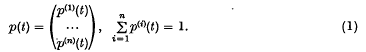
The type of Markoff process which is considered in this paper corresponds to a system capable of n states, the time being regarded as a continuously varying parameter. At any instant t the probability distribution is represented by the vector

Two maximal subgroups of a collineation group in five dimensions
-
- Journal:
- Mathematical Proceedings of the Cambridge Philosophical Society / Volume 46 / Issue 4 / October 1950
- Published online by Cambridge University Press:
- 24 October 2008, pp. 555-569
- Print publication:
- October 1950
-
- Article
- Export citation
The paradox of separated systems in quantum theory
-
- Journal:
- Mathematical Proceedings of the Cambridge Philosophical Society / Volume 46 / Issue 4 / October 1950
- Published online by Cambridge University Press:
- 24 October 2008, pp. 620-625
- Print publication:
- October 1950
-
- Article
- Export citation
The Adoption of Decca as an Aid to Navigation at Sea
-
- Journal:
- The Journal of Navigation / Volume 3 / Issue 4 / October 1950
- Published online by Cambridge University Press:
- 18 January 2010, pp. 336-346
- Print publication:
- October 1950
-
- Article
- Export citation
The Double Altitude Problem: A Historical Note
-
- Journal:
- The Journal of Navigation / Volume 3 / Issue 4 / October 1950
- Published online by Cambridge University Press:
- 18 January 2010, pp. 416-421
- Print publication:
- October 1950
-
- Article
- Export citation
The extremal values of Legendre polynomials and of certain related functions
-
- Journal:
- Mathematical Proceedings of the Cambridge Philosophical Society / Volume 46 / Issue 4 / October 1950
- Published online by Cambridge University Press:
- 24 October 2008, pp. 549-554
- Print publication:
- October 1950
-
- Article
- Export citation
-
1. The tabulated values of the Legendre polynomials suggest that the right-hand minimum of Pn(x) changes monotonically as n increases. Let xr, n be the value of x which gives the rth extreme value to the left of 1 of Pn(x). Then we can show that
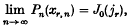
where jr is the rth pösitive zero of J1(z), and that after some term the sequence Pn(xr, n) is monotonic with the moduli of the terms decreasing. We cannot, however, show that the sequence is monotonic from the place at which its terms become significant.

Discussion
-
- Journal:
- The Journal of Navigation / Volume 3 / Issue 4 / October 1950
- Published online by Cambridge University Press:
- 18 January 2010, pp. 350-356
- Print publication:
- October 1950
-
- Article
- Export citation
NAV volume 3 issue 3 Cover and Front matter
-
- Journal:
- The Journal of Navigation / Volume 3 / Issue 3 / July 1950
- Published online by Cambridge University Press:
- 01 July 1950, pp. f1-f12
- Print publication:
- July 1950
-
- Article
-
- You have access
- Export citation
PSP volume 46 issue 3 Cover and Front matter
-
- Journal:
- Mathematical Proceedings of the Cambridge Philosophical Society / Volume 46 / Issue 3 / July 1950
- Published online by Cambridge University Press:
- 24 October 2008, pp. f1-f2
- Print publication:
- July 1950
-
- Article
-
- You have access
- Export citation
Preventive Navigation
-
- Journal:
- The Journal of Navigation / Volume 3 / Issue 3 / July 1950
- Published online by Cambridge University Press:
- 01 July 1950, pp. 228-246
- Print publication:
- July 1950
-
- Article
- Export citation
Corporate Members
-
- Journal:
- The Journal of Navigation / Volume 3 / Issue 3 / July 1950
- Published online by Cambridge University Press:
- 01 July 1950, pp. 315-316
- Print publication:
- July 1950
-
- Article
- Export citation
An Examination of Present Day Problems
-
- Journal:
- The Journal of Navigation / Volume 3 / Issue 3 / July 1950
- Published online by Cambridge University Press:
- 01 July 1950, pp. 211-212
- Print publication:
- July 1950
-
- Article
- Export citation
