
American cities are segregated along racial lines and, even as the country grows more racially diverse, some degree of segregation appears to be a durable feature of urban life (Menendian, Gambhir, and Gailes Reference Menendian, Gambhir and Gailes2021). Political scientists have paid close attention to the relationship between segregation and the distribution of goods and services in a given city, where minority neighborhoods are underinvested and over-policed (Trounstine Reference Trounstine2016; Gelman, Fagan, and Kiss Reference Gelman, Fagan and Kiss2007). Less attention has been paid to an important feature of segregation: the transitional zones where racial enclaves meet, and where homogeneity momentarily gives way to diversity, use of space becomes mixed, inequality becomes apparent, and where the powerful and marginalized mingle. Evincing the geopolitical significance of these spaces, scholars elsewhere observe a relationship between racial boundary zones and elevated crime, which they attribute to heightened intergroup conflict (Legewie and Schaeffer Reference Legewie and Schaeffer2016; Legewie Reference Legewie2018; Neil and Legewie Reference Neil and Legewie2023; Kramer Reference Kramer2017; Dean et al. Reference Dean, Dong, Piekut and Pryce2019; Kim and Hipp Reference Kim and Hipp2022). Boundary zones, then, are center stage for race relations in American cities where longstanding theories about racial conflict, defended borders, and out-group hostility are all uniquely salient.
We ask how is police behavior organized around and impacted by racial boundaries in American cities? Sociologists have argued that racial and economic differences lessen social cohesion, drive inter-personal conflict, elevate crime, and prompt white citizens to make requests for police intervention to regulate the non-white people around them (Kramer Reference Kramer2017; Legewie Reference Legewie2018; Kim and Hipp Reference Kim and Hipp2022; Abascal and Baldassarri Reference Abascal and Baldassarri2015; Harris, Rigolon, and Fernandez Reference Harris, Rigolon and Fernandez2020). Focusing on the behavior of citizens, they point to individual attitudes—particularly out-group threat—as key mechanisms driving increased police presence in racial boundary zones. While such emergent factors no doubt contribute to heightened police activity, qualitative accounts describe how state-centric practices organize the deployment of police in and around these same spaces (Gordon Reference Gordon2022). Law enforcement do more than respond to civilian calls for service and actualized crime (demand-side factors for police intervention with civilians); they approach public safety proactively, deploying officers in spaces typed as high crime, with the goal of upholding social order, inclusive of maintaining segregation and subjugating non-white communities (Burch Reference Burch2013; Bell Reference Bell2020). As such, racial boundary zones are likely the subject of heightened scrutiny by police in ways that do not map neatly onto observed crime. This is our central thesis: Crime that occurs in boundary zones is likely to receive more attention than crime that occurs in non-boundary zones for both demand-side reasons and top-down processes that structure racial inequality in the modern city.
Empirically, our primary goal is to measure slippage between crime and police activity in boundary zones. To do this, we leverage a feature of modern policing: the reliance on preemptive strategies whereby officers intervene in low-level infractions to prevent them from escalating to more serious crime, and which are most likely to result in low-level, misdemeanor charges. These kinds of activities are subject to officer discretion and are a chief mechanism by which police exert social control. To further excavate the social control function of the state in boundary zones, we attend to the racial dynamics of who gets stopped and where. Importantly, we argue that racialized policing occurs (at least in part) as a consequence of practices that dictate where police are deployed and who is likely to commit crime. As such, racialization moves through the particularized regulation of space, which may yield heightened police activity in white spaces and towards white people, as well as in non-white spaces and non-white people when in boundary zones. Through our empirical effort to disentangle policing from crime, we theoretically reorient the study of boundary zones around the top-down processes that structure racial inequality in the modern city.
Using data from seven cities—Atlanta, Austin, Boston, Chicago, Louisville, Milwaukee, and Seattle—we employ methods of areal wombling to operationalize racial boundaries (Leg ewie and Schaeffer Reference Legewie and Schaeffer2016; Legewie Reference Legewie2018), which we pair with granular data on police stops, arrests, and crime (Verrilli et al. Reference Verrilli, Roman, Walker, Epp, Liu and Findley2025). We observe a clear pattern consistent with our expectations. In all seven cities, police arrests and stops occur more frequently in neighborhoods that demarcate racial boundary lines than in neighborhoods not proximate to relative racial out-groups. This relationship is especially pronounced with reference to infractions that are endogenous to police activity (offenses likely to result in a misdemeanor) and persists conditional on localized crime. The results of a moderation analysis suggest that crime in transitional zones receives more police attention than crime in non-transitional zones. Patterns of location of arrests and race-of-arrestee suggest that demand-side factors are unlikely to fully account for the extra attention boundary zones receive from police and instead we observe patterns consistent with the theoretical claim that supply-side factors are central to these dynamics.
We build on rich ethnographic work to develop a set of theoretical expectations about how police interact with transitional spaces, and leverage a novel, data-driven metric of racial boundaries to test those expectations. Yet the implications of our work are greater than our present focus on crime. Scholars have long recognized the political importance of borders in contexts outside the United States, and the central role for police in protecting the status of privileged classes (Braun and Kienitz Reference Braun and Kienitz2022; Moser and Rodgers Reference Moser and Rodgers2005; Hassner and Wittenberg Reference Hassner and Wittenberg2015; Carter and Poast Reference Carter and Poast2017). While little attention has been given to the production and maintenance of such borders in cities (Braun and Kienitz Reference Braun and Kienitz2022), research elsewhere documents the active role police play in processes of investment and urban renewal (Muñiz Reference Muñiz2015; Laniyonu Reference Laniyonu2018). We provide fresh evidence that these dynamics are operative across U.S. cities, and we further develop the concept of racial boundaries to encompass the institutional processes by which they develop. Racial animus among citizens is one aspect of this story (Neil and Legewie Reference Neil and Legewie2023; Legewie and Schaeffer Reference Legewie and Schaeffer2016). Yet policies and practices that organize police activities—including where they are deployed and the imperative to preempt crime—render law enforcement active participants in the regulation of race and production of segregation.
Background and Theory
A natural consequence of segregation are boundary zones, which sociologists describe as, “interstitial or transitional areas sandwiched between two homogeneous communities” (Legewie and Schaeffer Reference Legewie and Schaeffer2016, 124). As the spaces where different neighborhoods meet, boundary zones are revealing of interracial dynamics and local power struggles. Moreover, to the degree that racial and class-based segregation circumscribe the distribution of municipal resources, this can be seen most starkly at boundary zones, where “objective forms of social differences [manifest] in unequal access to and unequal distribution of resources” (Dean et al. Reference Dean, Dong, Piekut and Pryce2019, 272).
A lengthy literature identifying boundary zones as deeply political places develops from scholarly attention to borders between countries and the conditions under which those borders become more (or less) regulated (Braun and Kienitz Reference Braun and Kienitz2022). Notably, defense of resources drives the establishment of physical fortification, and scholars have likewise observed that municipal security often develops to protect private wealth—this is particularly stark when states bifurcate access to citizenship along ethno-racial lines and fail to adequately provide for public safety (Spocter Reference Spocter2022; Simmons and Kenwick Reference Simmons and Kenwick2022; Robins Reference Robins2002; Davies Reference Davies1981; Clarno and Murray Reference Clarno and Murray2013). The state has an interest in responding to the demands of wealthy and powerful constituents, but it also has an interest in promoting economic development within cities. In the United States, law enforcement have been deployed for this exact purpose by regulating access to and movement between invested and disinvested spaces (Desmond and Valdez Reference Desmond and Valdez2013; Beck Reference Beck2020; Collins, Stuart, and Janulis Reference Collins, Stuart and Janulis2022; Laniyonu Reference Laniyonu2018). Strategies of order maintenance policing, also referred to as “broken windows policing”, provide the institutional basis by which this occurs. The logic underlying order maintenance policing is that law enforcement can enhance feelings of public safety through regulating how people interact with space (like preventing loitering) and dictates that they should pursue low level infractions associated with misdemeanor charges in order to prevent more serious crime (Herbert and Beckett Reference Herbert and Beckett2017).
Such practices provide a legal mechanism for law enforcement to use discretion when making decisions about who to stop and where, but the deployment of these tactics are also at least in part in response to citizen’s demands, vis-à-vis 311 and 911 calls (Harris, Rigolon and Fernandez Reference Harris, Rigolon and Fernandez2020). As one scholar put it, “the history of planning could be rewritten as the obsession with managing fear in the city” (Sandercock Reference Sandercock2000, 205)—where public space is increasingly organized around consumption, law enforcement are deployed to create an environment supportive of consumption-related activities and are highly responsive to wealthy citizens and business owners (Summers and Howell Reference Summers and Howell2019). Empirically, scholars have focused on the extent to which race and class boundaries foster intergroup conflict and in turn, criminogenic behavior (Kim and Hipp Reference Kim and Hipp2022; Legewie Reference Legewie2018; Dean et al. Reference Dean, Dong, Piekut and Pryce2019). Evidence from New York city suggests that non-whites are at higher risk of arrest when on the white side of the line in boundary zones—at least in part because white residents are especially prone to requesting police intervention in their neighborhoods (Neil and Legewie Reference Neil and Legewie2023; Legewie and Schaeffer Reference Legewie and Schaeffer2016).
Intergroup conflict among citizens no doubt yields heightened police presence in racial boundary zones. Yet civilian demands for police intervention that spring from intergroup conflict work alongside top-down decisions about where and how to allocate police resources. Ethnographic work provides a thick account of police regulation of disadvantaged spaces and boundaries (Gordon Reference Gordon2022). For example, in Gordon’s description, the construction of administrative boundaries that circumscribe police work (like police beats) themselves provide a means for the unequal distribution of law enforcement resources. Law enforcement began with beliefs about the utility of a community policing approach, but filtered through notions about coherent neighborhoods, themselves embedded with race and class biases about criminal pathology and value. Thus, comparatively white, wealthy, and economically developed spaces received different resources than poorer neighborhoods with larger racial minority populations. Describing these dynamics, Gordon (Reference Gordon2022) writes:
Strategic priorities and district-level resources intersected with divergent work environments to produce vastly different experiences of patrol work for officers and experiences of policing for citizens. Race entered into these processes as long standing structural inequalities, and symbolic associations—particularly those associating Black neighborhoods with crime and white neighborhoods with value—shaped organizational structures and strategic priorities. Policing practices further constructed racialized geographies by delivering service and social control unevenly across the city’s segregated places and populations. (143)
Gordon’s work on the differential distribution of law enforcement resources relative to patterns of development is important because it explicates the role police play in maintaining geographic racial divisions by managing the flow of people around invested districts and in how they respond to requests for service. Scholars elsewhere find that adjacency to a minority neighborhood is a stronger predictor of use-of-force incidents than is neighborhood composition, providing evidence that police engage racial boundary zones differently than other parts of the city (Omori, Lautenschlager, and Stoler Reference Omori, Lautenschlager and Stoler2022). It is not simply that police provide better services to invested spaces than to disinvested ones. Citizen-driven and organizational dynamics cohere to produce differential policing in and out of the borders between said spaces, and likely do so in ways that diverge from crime. This produces our primary hypothesis:
Hypothesis 1: Crime in boundary zones will receive more attention from police than crime in non-boundary zones.
Complementing empirical work on the citizen-side factors that yield extra policing in boundary zones, and following the theoretical intuitions developed by Gordon (Reference Gordon2022), we critically engage the organizational factors that promote the differential regulation of space. Research around how police aid gentrification identifies order maintenance policing practices as essential tools to regulate poverty, consumption, and investment (Desmond and Valdez Reference Desmond and Valdez2013; Laniyonu Reference Laniyonu2018; Beck, Reference Beck2020; Collins, Stuart, and Janulis Reference Collins, Stuart and Janulis2022; Muñiz Reference Muñiz2015). To wit, under the height of the stop-and-frisk program in New York City, stops overall were more prevalent and less efficacious in boundary zones than in more racially homogeneous spaces (Legewie and Schaeffer Reference Legewie and Schaeffer2016). As focused as order-maintenance policing strategies are on preempting rather than reacting to crime, these practices are endogenous to the kinds of crimes that are ultimately reported (low-level activity likely to result in a misdemeanor charge, for example; Desmond and Valdez Reference Desmond and Valdez2013; Herring Reference Herring2019; Harris, Rigolon, and Fernandez Reference Harris, Rigolon and Fernandez2020; Huff Reference Huff2021). On the other hand, arrest rates for violent felonies are less likely to be driven by geographical considerations (i.e., they should prompt a police response wherever they occur). We therefore expect that to the extent police give attention to boundary zones in excess of crime, this should be most readily observable in police activity addressing low-level, non-violent activity:
Hypothesis 2: The positive association between racial boundaries and police activity will be most readily observable with respect to the regulation of low-level offenses not associated with a felony offense.
We are further interested in the racial dynamics of policing in racial boundary zones. On one hand, we might expect that police heavily target non-white people in non-white spaces in order to protect white privilege (Muñiz Reference Muñiz2015), or that heightened policing mostly occurs on the white side of the line as white people call on police to regulate their space (Neil and Legewie Reference Neil and Legewie2023). Yet Gordon directs our attention to how institutional practices can yield racialized outcomes without implicating individual explicit, racialized attitudes, writing that “[officers] could generate racial disparities without racial intent: they did so just by following their official duties within the circumscribed work environment of the police district. Racial outcomes in policing were facilitated by organizational structures like district boundaries, resource allocations, deployment decisions, formal policies and legal standards” (2022, 183). To the extent law enforcement views boundary zones as in need of additional regulation, law enforcement resources should be distributed in boundary zones in ways that are commensurate on both sides of the boundary, but elevated relative to co-ethnic, homogeneous spaces:
Hypothesis 3: Heightened police activity in boundary zones will occur on both sides of the boundary, relative to co-ethnic, homogeneous spaces that are not in boundary zones.
Police make further decisions about how, when, and with whom to intervene. When such decisions are made with little evidence of actualized crime, officers rely on other kinds of heuristics to determine potential criminality, which in turn can reify social hierarchies rooted in said heuristics (Gordon Reference Gordon2022; Epp, Maynard-Moody, and Haider-Markel Reference Epp, Maynard-Moody and Haider-Markel2014; Harris, Rigolon, and Fernandez Reference Harris, Rigolon and Fernandez2020; Gaston Reference Gaston2019; Kane Reference Kane2006). Regarding segregation, Gordon writes that it “created a series of associations that shaped police action, which, in turn, reified the realities of segregation … racial and spatial segregation was so entrenched and naturalized that the police problematized any boundary crossing,” (2022, 163).
It follows from the institutional perspective on policing, where individual prejudices held by either police or civilians are less important than are the routinized policies and practices that police are trained to engage in, that individuals are likely to be stopped when in neighborhoods where they appear to be out of place, irrespective of civilian race. Indeed, courts have ruled that the fish-out-of-water heuristic is a justifiable component of reasonable suspicion (Novak and Chamlin Reference Novak and Chamlin2012; Gaston Reference Gaston2019; Hannon, Neal, and Gustafson Reference Hannon, Neal and Gustafson2021). Scholars have paid special attention to its application to non-white bodies in predominantly white spaces. However, the institutional perspective suggests that police are patrolling racialized spatial boundaries, and as such the fish-out-of-water heuristic should be operative in reference to both white and non-white civilians when they are out of place in boundary zones (Bell Reference Bell2020).
This is not to say that white and non-white people face equal risk of arrest when out of place. Scholars have demonstrated that the fish-out-of-water heuristic is unequally applied writ large, without attention to boundary or non-boundary zones (Hannon, Neal, and Gustafson Reference Hannon, Neal and Gustafson2021; Gaston Reference Gaston2019). Instead, the fish-out-of-water heuristic provides an institutional mechanism by which racialized policing in boundary zones might occur in ways that exceed civilian requests for intervention. If we observe that both white and non-white people face heightened risk of arrest when in boundary zones and are racially out of place relative to when in homogeneous zones, this provides evidence that institutional mechanisms promote the policing of racial boundaries, in addition to civilian demands that develop from intergroup conflict and feelings of out-group threat. The key comparison is to other members of one’s racial subgroup. We do not attempt to adjudicate between citizen and organizational factors that promote heightened policing in racial boundary zones. Instead, this hypothesis and the attendant empirical test provide a means to evaluate whether organizational factors can be observed to shape the politics of racial boundaries in American cities. Our final hypothesis, then, is as follows:
Hypothesis 4: Individuals in boundary zones will face heightened risk of arrest when they are racially out of place than when they are in more homogeneous spaces; this will be true for both white and non-white individuals.
In sum, we argue that racial boundary zones are spaces that command special attention from municipal police departments. Existing empirical accounts spotlight the demand-side factors that yield heightened police activity in racial boundary zones. Our goal is to develop complementary evidence for the supply-side factors that generate not just more activity, but attention that exceeds that given to crime in homogeneous spaces. We leverage Gordon (Reference Gordon2022)’s ethnographic account of how boundaries organize law enforcement behavior to develop a set of expectations around the relationship between policing in boundary zones and crime, and the unique character policing takes in said spaces. In what follows, we leverage Legewie’s novel, data-driven metric that allows us to identify organic demographic transitional zones (Legewie and Schaeffer Reference Legewie and Schaeffer2016; Legewie Reference Legewie2018; Neil and Legewie Reference Neil and Legewie2023) and evaluate policing in racial boundary zones across seven cities.
Data and Design
Our measure of police activity is arrests. Prior evidence suggests arrests measure policing activity net of crime, since many arrests are discretionary and motivated by officer biases (Stashko Reference Stashko2018). We collected incident-level arrest data across several cities: Atlanta, GA; Austin, TX; Boston, MA; Chicago, IL; Milwaukee, WI; and Seattle, WA. We also collected data for Louisville, KY. For this particular locality, we were only able to obtain records for felony arrests. However, we argue that low-level infractions most likely to result in a misdemeanor offense result from processes that are most reflective of officer discretion, and as such, that misdemeanor arrests are the most sensitive measure of excessive policing. This logic gives rise to hypothesis 2. In the case of Louisville, we distinguish between felony arrests for crimes against persons, property and society, where we are likely to see effects stemming from crimes against property and society, relative to crimes against persons. For the sake of parsimony, we present the findings from the six cities where we have records of misdemeanor arrests and discuss the findings from Louisville (located in the appendix) where appropriate. While we set out to incorporate more cities, these seven provided us with the complete range of data necessary for our analysis. For instance, some cities for which we had incident-level arrest data such as El Paso, Oklahoma City, and Idaho Falls lacked incident-level crime data, while others such as Baltimore, had crime data but largely lacked addresses of arrests. Table 1 displays the kind of data we were able to attain for each city.
Table 1 Data availability for seven cities
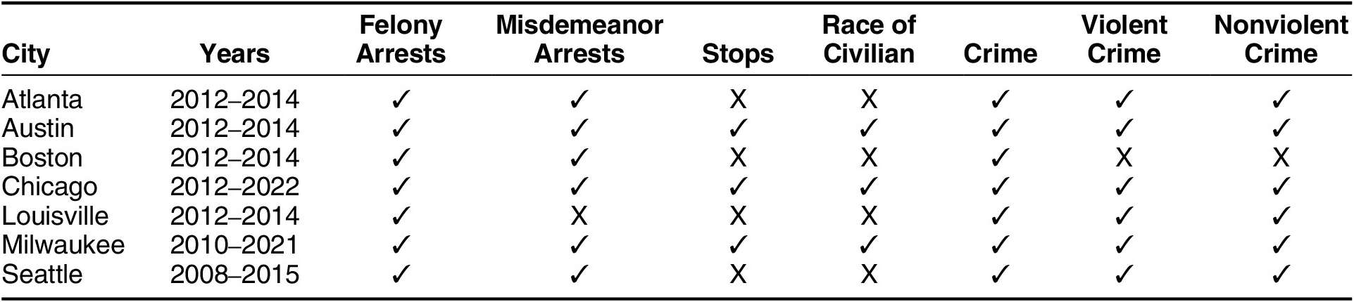
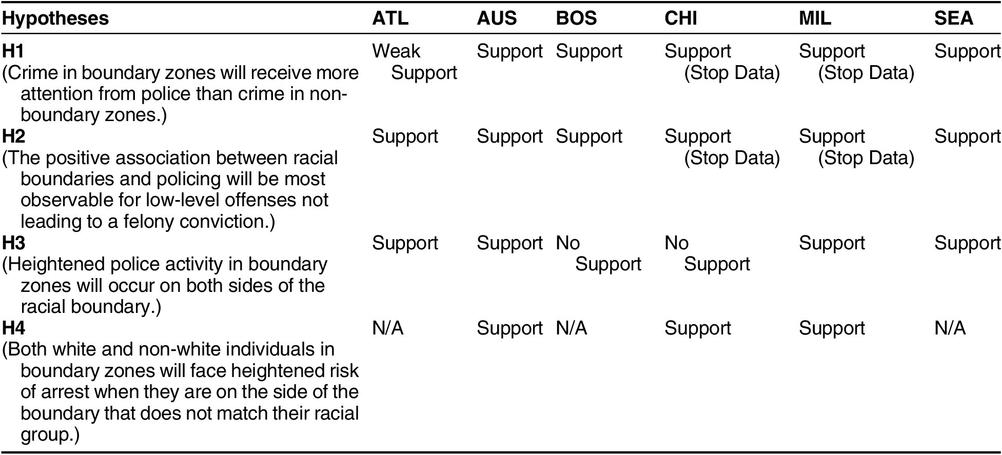
Table 2 Summary of results by hypothesis and city
These cities range widely in geographic location, racial composition, and histories with policing. Evaluating policing patterns across multiple cities allows us to assess the generalizability of our theory and account for departmental idiosyncrasies across multiple urban contexts. While we sought the broadest time window possible from each department, we succeeded in obtaining complete data on arrests between 2012–2014 for every city. To prepare the data for analysis, we 1) geocode each arrest location and 2) geolocate each arrest inside its respective 2010 Census block (U.S. Census Bureau 2010). We omit warrant arrests as police may exercise less discretion during warrant arrests and they may occur in locations that are distinct from offense locations. We summarize the number of total arrests and arrests by category (misdemeanor and felony) between 2012–2014 for each block and log the outcome (plus 1 to ensure identification) to account for the right-skewed outcome distribution.
We chose to model arrests for two reasons: 1) arrests are the particular metric of police behavior for which we were able to obtain the broadest collection of U.S. cities; and 2) because arrests are more likely to occur with evidence of criminal activity, they are a hard test of our theory and biased against finding any differences between boundary and non-boundary zones. We think that felony arrests are suitable for analysis since many do not lead to a criminal conviction and arise from the same processes that yield misdemeanor arrests, but overall, we think felony arrests are less reflective of discretionary processes than are arrests for misdemeanor infractions. Misdemeanor arrests are correlated with our different measures of crime at the census block-level across cities between ρ = 0.3 - 0.73, a moderate-to-strong correlation (appendix table 4), implying arrests mostly occur where crime occurs, but the relationship is not 1-to-1, consistent with Hypothesis 1. One may argue that an alternative metric such as stops are more appropriate because they reflect discretionary police activity that may or may not reveal wrongdoing by the civilian, even as arrests occur when evidence of criminal behavior is apparent. We anticipate that estimates derived from arrests are conservative. We were able to obtain stop data for Austin, Chicago. and Milwaukee (indicated in table 1). To validate our central findings, we evaluate this data concurrently and reference it where appropriate. It becomes particularly important when we evaluate hypothesis four, which concerns the race of the civilian stopped. We prepare stop data in the same fashion applied to arrest data.
Our key independent variable is boundaries as defined by the level of racial difference between adjacent neighborhoods. Sociologists have developed innovative methods for detecting boundaries, to assess how spatial areas marked by deep demographic differences may lead to heightened conflict or decreased social cohesion (Legewie and Schaeffer Reference Legewie and Schaeffer2016; Kramer Reference Kramer2017; Dean et al. Reference Dean, Dong, Piekut and Pryce2019). To this end, we use an areal wombling technique, which detects boundaries based on differences in the values of spatial data derived from areal units (e.g., a census block or block group). We calculate racial boundaries at the census block level because they offer the granularity necessary to identify and analyze racial variation that may be diluted at the block-group level.
To measure racial boundaries we identify a given census block within a city context. We then identify its adjacent blocks. Next, we calculate the absolute value difference between the proportion of the block’s population that is white and the proportion white in its adjacent blocks (using 2010 decennial census data). We characterize racial boundaries using the white/non-white composition because it allows for consistent measurement across cities, even as the racial composition of each city varies. If we consistently identify an association between white/non-white boundaries and arrests even given this variation, then we can be confident that our theory travels across a wide array of ethno-racial contexts and, moreover, that a primary way in which racial boundaries operate is on the basis of whiteness. Following Legewie (Reference Legewie2018), we take the maximum difference and use that as the racial boundary value. This helps to capture drastic geographic boundaries between predominantly white and non-white blocks.Footnote 1 The equation to calculate the racial boundary measure is:
 $$ {racialboundary}_i={max}\left(|\%{white}_i-\%{white}_{ij}|\right) $$
Where i represents census block i. j are neighboring blocks to i, where j = {1…ni} in n neighbors to i. The boundary value is scaled between 0–1, where 0 represents no difference in the proportion of the population that is white between adjacent areas, and 1 represents a maximum difference. As the demographic maps in Figure 1 demonstrate visually, racial boundaries capture the relative racial concentration of a given subgroup at the block level, although the quantities of interest represent points of inequality rather than homogeneity. Appendix table 1 provides further information about the measure demonstrating that there are no large outliers in the measure across all cities and comparing the boundary measure to the level of racial segregation in each city context. We use this continuous measure to evaluate hypotheses 1 and 2, which posit that police will give more attention to crime in boundary zones than non-boundary zones, and that this will be more apparent among arrests leading to a misdemeanor conviction. We are also concerned with the moderating effect of crime and racial composition on policing in boundary zones. Following the observation by Legewie and Schaeffer (Reference Legewie and Schaeffer2016) that boundaries characterized by the steepest racial differences also feature the starkest differences in public safety outcomes, we dichotomize the boundary metric such that those census blocks with a boundary score that falls in the top quartile of racial difference are coded as one and those falling below the top quartile of racial difference are coded as zero.
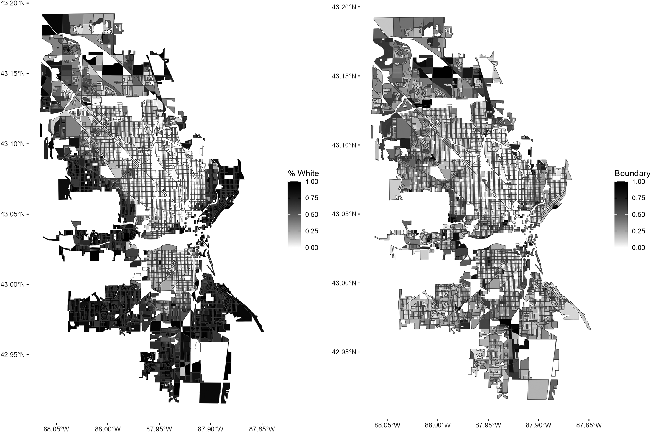
Figure 1 Racial boundaries in the city of Milwaukee
Note: The map on the left displays the percentage of the population that is white by block using 2010 decennial census data. The map on the right displays the white racial boundary value by census block
Previous work has found greater levels of crime at racial boundaries (Legewie and Schaeffer Reference Legewie and Schaeffer2016; Kramer Reference Kramer2017; Kim and Hipp Reference Kim and Hipp2022; Dean et al. Reference Dean, Dong, Piekut and Pryce2019; Legewie Reference Legewie2018). Our central claim in this paper is that police activity is distributed in ways that reflect additional interests and power arrangements and does not strictly map onto crime. To account for criminal activity, we gather incident-level crime data for each city. First, we subset the crime data to the same date range as the corresponding arrest data. Second, we distinguish between violent and property crimes, which will serve as two distinct crime types for which we adjust.Footnote 2 Third, we geolocate each incident into its respective census block. Finally, we sum the total crimes for each type, for each census block, during 2012–2014. We evaluate whether we observe excess police activity in boundary zones relative to crime with two tests: we include control variables for crime type and perform a sensitivity analysis to evaluate the robustness of the relationship between boundaries and policing after conditioning on crime; and we assess whether crime moderates the relationship between arrests and boundary zones. This allows us to evaluate whether crime in boundary zones receives more attention than crime outside boundary zones.Footnote 3
We adjust for several block-level characteristics that may jointly explain police activity and racial boundaries. We adjust for population (logged), the proportion of the male population that is 15–35, the proportion of the population that is white, the level of commercial activity in the block, the presence of physical boundaries, and ethno-racial diversity across the four major ethno-racial groups in the U.S. (non-Latinx white, non-Latinx Black, Latinx, non-Latinx Asian) using the Herfindahl index. We leverage percent white to evaluate Hypothesis 3. Hypothesis 3 expects that heightened arrests in boundary zones will be distributed on both the white and the non-white side of the boundary. To test this, we employ a moderation analysis between the racial boundary metric and percent white. We leverage a similar strategy to evaluate Hypothesis 4, which concerns the race of the civilian stopped and where. To assess this, we repeat the moderation analysis, but we subset by race of civilian among cities where we have this information (Austin, Chicago, and Milwaukee).
We also adjust for several socio-economic characteristics, including percent homeowners, logged median household income, percent in poverty, percent unemployed, and percent college-educated.Footnote 4 However, the Census provides these variables at the block group level, while our racial boundary metric is calculated at the block level. Socio-economic differences, moreover, likely coincide with racial differences and are an alternative explanation for any disparate police activity in and out of boundary zones we may observe. In order to craft a measure of socio-economic boundaries that is commensurate with our racial boundary metric, we followed methods developed by Wang et al. (Reference Wang, Qian, Kats, Kontokosta and Sobolevsky2017) and leverage an alternative data source to measure socio-economic status at more granular levels than is available via the Census: incident-level 311 call data. Briefly, we identify call types associated with more affluent neighborhoods, calculate the proportion of calls overall for which those categories account, and use areal wombling to identify points of socio-economic difference at the block level. The result is an SES boundary measure at the same level of aggregation as our racial boundary measure.Footnote 5
We use the following linear model for each city to test our hypotheses:
 $$ Log\left({Arrests}_i+1\right)={\displaystyle \begin{array}{l}\alpha +{\beta}_1{racialboundary}_i\\ {}+\hskip2px {\beta}_2{econboundary}_i\\ {}+\hskip2px \sum \limits_{k=1}^k{\beta}_{k+2}{X}_{ib}^k+{\varepsilon}_{ib}\end{array}} $$
where Arrestsi is the number of arrests in census block i, racialboundaryi is the racial boundary measure scaled between 0–1 at the block-level (i), and econboundaryi is the socioeconomic boundary measure scaled between 0–1 at the block-level (i). $ {\sum}_{k=1}^k{X}_{ib}^k $
are k block and block group-level covariates. εib are block group-clustered errors.
$ {\sum}_{k=1}^k{X}_{ib}^k $
are k block and block group-level covariates. εib are block group-clustered errors.
Results
Assessing Police Attention to Crime in Boundary Zones
Figure 2 displays the relationship between boundary zones and police activity among misdemeanor arrests (left panel) and among felony arrests (right panel). For the purposes of cross-city comparison, we standardize the logged arrest variable by subtracting the quotient of the mean logged arrests divided by the standard deviation of logged arrests. Thus, our dependent variable represents the change in arrests by standard deviation units in response to going from the minimum value to the maximum value of racial boundaries. Recall that hypothesis 1 posits that relative to non-boundary zones, crime in racial boundary zones will receive greater police attention (in this case, arrests). Hypothesis 2, moreover, posits that the discordant relationship between police activity and crime in boundary zones will be most apparent in reference to low-level, non-violent infractions of the sort leading to a misdemeanor conviction.
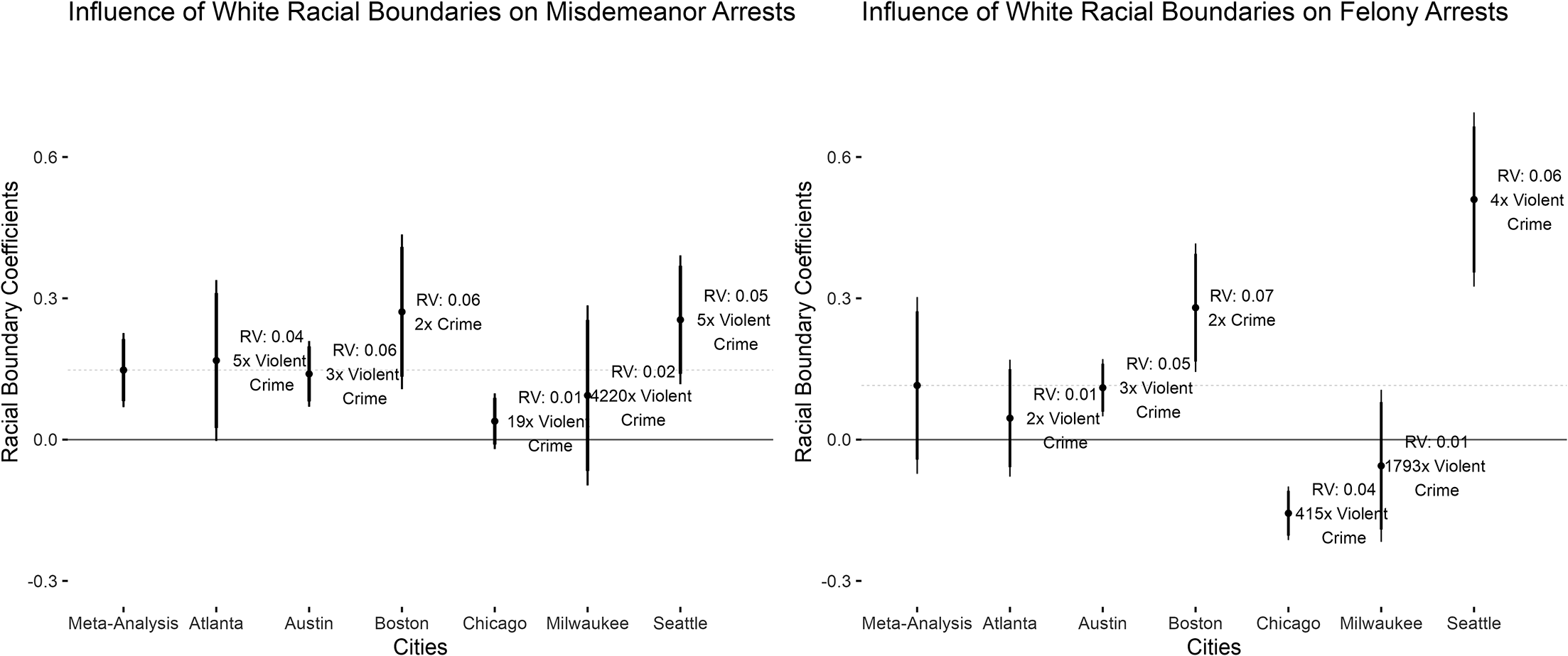
Figure 2 Influence of racial boundary on logged arrests (standardized)
Annotations denote the robustness value and bounding variable value necessary to attenuate the substantive influence of racial boundaries to 0.
Figure 2 provides evidence in support for both Hypothesis 1 and Hypothesis 2. A random effects meta-analytic estimate on figure 2 shows logged misdemeanor arrests increases by 0.15 standard deviations in response to a shift from the minimum to the maximum racial boundary level. Substantively, this is a large coefficient, equivalent to an average increase in 0.41 misdemeanor arrests for a given block across all cities. Although an increase in 0.41 misdemeanor arrests may seem small at the outset, this is substantively important given that average block-level misdemeanor arrests across cities is, on average, relatively small (3 arrests). The size of the meta-analytic estimate for felony arrests (right panel, figure 2) is slightly smaller and just shy of conventional levels of statistical significance, but racial boundaries are still positively associated with logged felony arrests. With respect to misdemeanor arrests, there is a positive and significant association with racial boundaries in every city except for Chicago and Milwaukee where the association is positive and but not significant. There is more variation with respect to felony arrests, where Atlanta, Chicago, and Milwaukee do not display a positive and significant association with racial boundaries. Across all cities, violent crime is the most prognostic covariate of arrests (except Boston, where lack of disaggregated crime data shows crime, writ large, is the most prognostic). Therefore, we use violent crime as a bounding covariate to assess the sensitivity of the impact of racial boundaries to confounding variables using tools by Cinelli and Hazlett (Reference Cinelli and Hazlett2020). At minimum (Boston), we find that a confounding variable would have to have twice the explanatory power of crime to reduce the positive influence of racial boundaries on misdemeanor arrests to 0. In all other cities, where we are able to distinguish between violent and nonviolent crime, we find that a confounding variable would have to have three (Austin) to five (Seattle) times the explanatory power of violent crime to reduce the observed relationship between boundaries and misdemeanor arrests to 0. Given that crime is arguably the most prognostic covariate of arrests, it is unlikely such a confounder exists that would attenuate the estimates to 0. We take this as evidence that boundary zones experience an excess of policing relative to observed crime, and to non-boundary zones.
The observed relationship between racial boundaries and police activity also persists conditional on several community-specific variables. The impact of racial boundaries on arrests is more consistently positive and significant than is the impact of socio-economic boundaries. In several instances, the size of the coefficient for racial boundaries is larger than that of socio-economic boundaries by orders of magnitude. For example, among misdemeanor arrests in Austin, the size of the coefficient of racial boundaries is twice the size of the coefficient for socio-economic boundaries (0.14 for racial boundaries relative to 0.07 for socio-economic boundaries). In Boston and Seattle, the explanatory power of socio-economic boundaries approaches zero, while the size of the coefficient for the racial boundary exceeds 0.2 standard deviations. While we do observe that percent living below the poverty line in a given census block group exerts significant influence on police activity across all cities under study, it remains notable that the influence of racial boundaries remains consistently and strongly prognostic of misdemeanor arrests. The fully specified models are found in appendix table 3 and appendix table 4.Footnote 6
Two additional pieces of evidence on this point are worth mentioning. We also evaluated these relationships in Louisville, where we only have felony arrests. We are able to distinguish between arrests for/against persons, property, and society crimes. The findings are consistent with those presented earlier. There is a positive relationship between arrests and racial boundaries across all three categories, but the size of the coefficient is larger for against property and against society arrests than for against persons arrests. The change in arrests from the minimum to the maximum value of racial boundaries is less than 0.07 standard deviations among against person arrests, and this grows to 0.21 and 0.22 standard deviations among felony arrests stemming from against property and against society infractions.
A sensitivity analysis indicates that the relationship is very robust to confounding variables. This analysis can be found in appendix figure 5 and appendix table 6.
We were able to obtain stop data from three cities: Austin, Chicago, and Milwaukee. Arguably, stops are a better metric of discretionary police activity of the kind that define and organize the social control activities in which police engage (Epp, Maynard-Moody, and Haider-Markel Reference Epp, Maynard-Moody and Haider-Markel2014; Baumgartner, Epp, and Shoub Reference Baumgartner, Epp and Shoub2018). We therefore evaluate the relationship between police stops and racial boundaries in the cities where we have this data.Footnote 7 Again, the findings corroborate those presented earlier. In all three cities, racial boundaries are positively associated with stops net of crime. The meta analytic coefficient is much larger than it is for arrests (0.15 standard deviations for arrests relative to 0.4 standard deviations for stops). For example, in Austin the change in misdemeanor arrests from the minimum to the maximum value of racial boundaries is 0.14 standard deviations, relative to 0.46 standard deviations in stops. Across all three cities, the findings hold net of crime and are similarly robust to confounding variables. The full analysis is located in appendix figure 9 and appendix table 15. That an analysis of stops confirms the conclusions derived from an analysis of arrests should assure the reader that arrests function in the way we argue that they do, and that the findings around arrests are conservative estimates of the relationship between racial boundaries and police activity.
We are not only interested in whether the relationship between racial boundary zones and arrests persists after controlling for crime. More precisely, we are interested in whether crime receives more attention in racial boundary zones than crime in non-boundary zones. We do not argue that policing is completely separable from crime. Our central contention is that beliefs about where crime is likely to occur, who is likely to commit it, and the value of certain spaces and citizens relative to the threat they pose are baked into the policing tactics employed as part of routine efforts to combat crime. As such, public safety outcomes and the distribution of police resources should not be expected to fully covary with observed crime. In order to tease this out we employ a moderation analysis. The moderating effect of crime on the relationship between racial boundary zones and policing is displayed in figure 3 (felony arrests) and figure 4 (misdemeanor arrests). The full analysis associated with each figure is located in appendix table 7 and appendix table 8.
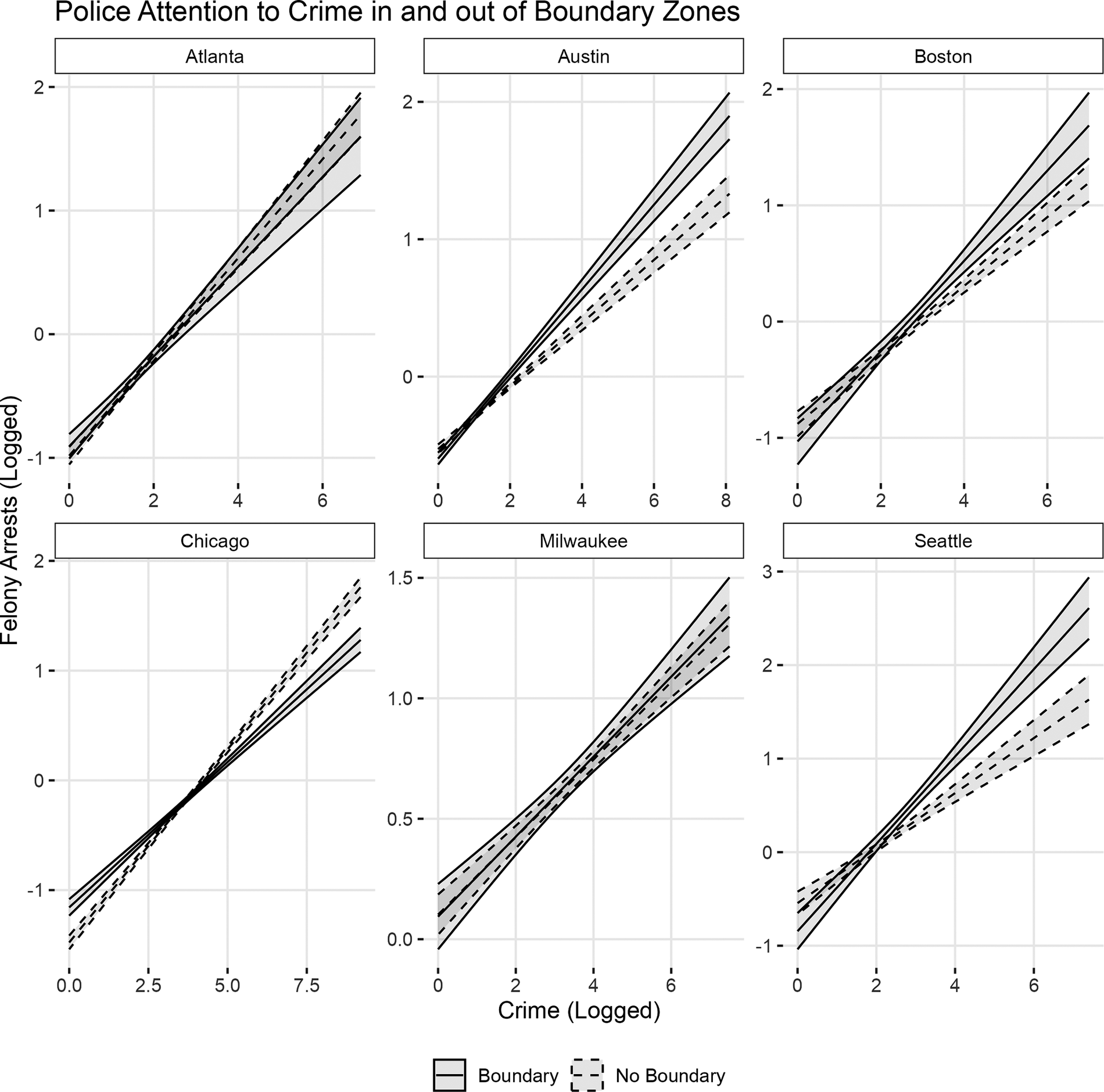
Figure 3 Influence of logged crime on logged felony arrests (standardized), conditional on racial boundary status
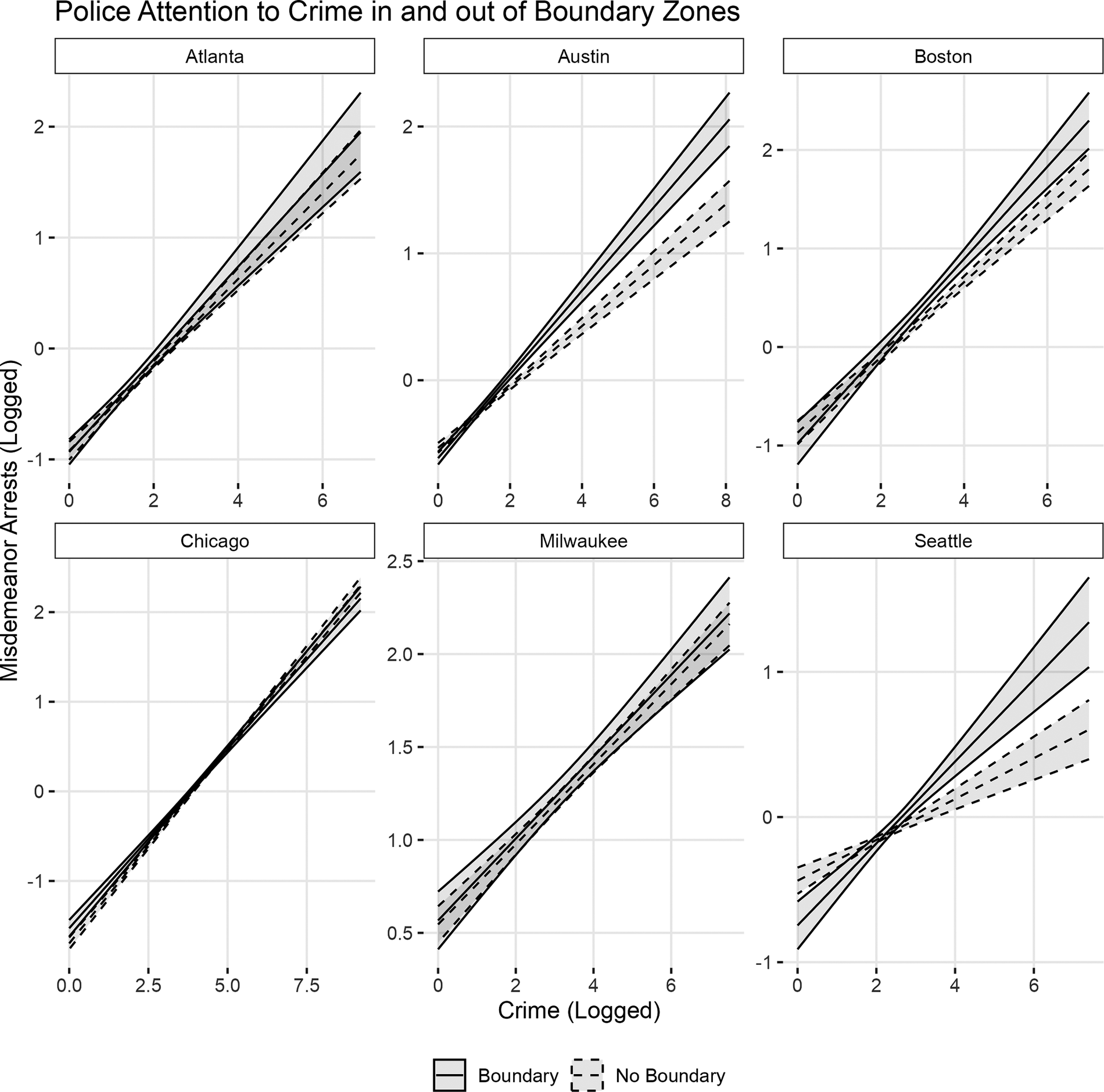
Figure 4 Influence of logged crime on logged misdemeanor arrests (standardized), conditional on racial boundary status
Figure 3, which displays the moderating effect of crime on the relationship between felony arrests and racial boundary zones, provides some evidence that crime in racial boundary zones receives excess police attention, but the findings are inconsistent. In Austin, Boston, and Seattle, among high crime neighborhoods the estimated level of felony arrests is higher in boundary zones than in non-boundary zones. Among low-crime neighborhoods, there is no difference in predicted arrests between boundary and non-boundary zones. Crime exerts a stronger pull on policing activity in boundary zones than it does in non-boundary zones. This suggests, potentially, that police are less responsive to crime in non-boundary spaces than in those spaces where racial groups abut one another. There does not appear to be any such relationship in Atlanta and Milwaukee, where predicted arrests follow crime closely. In Chicago, felony arrests appear to follow the opposite pattern, where crime in racially homogeneous spaces receives more attention than crime in boundary zones. With respect to misdemeanor arrests (displayed in figure 4) similar patterns emerge, although in Chicago we observe a closer relationship between crime and predicted arrests irrespective of boundary zone status. Thus, in Austin, Boston, and Seattle we observe evidence consistent with the idea that crime in boundary zones receives more attention than crime in non-boundary zones.
Louisville, for which we only have felony arrests, displays similar patterns to Austin, Boston, and Seattle. Predicted arrests are higher in high-crime boundary zones than in non-boundary zones. This relationship is particularly strong with reference to arrests for crimes against society, which is what we would expect to see given that this category of conviction is most sensitive to police discretion (the analysis is located in appendix figure 6 and appendix table 9). We also evaluate stop patterns where we have appropriate data, in Chicago, Austin, and Milwaukee. These findings are displayed in figure 5 (full analysis located in appendix table 16). Stop patterns in Austin conditional on crime are similar to arrest patterns, where racial boundary zones that are characterized by high crime are subject to more stops than are similarly situated non-boundary zones. Of particular note, however, are the findings in Chicago and Milwaukee. An examination of arrests in these two cities suggests that arrests more or less follow crime. However, as we note earlier arrests are a hard test of our theory, because while they derive from underlying discretionary processes, an arrest occurs in the presence of criminal activity. Stops can occur without evidence of criminal behavior and are a key source of police-initiated contact with civilians. Turning to the more precise metric of stops, we observe patterns of policing in Milwaukee and Chicago that are similar to arrest patterns observed in Austin, Boston, Seattle, and Louisville. High crime neighborhoods that are in racial boundary zones experience many more stops than do those that are not in racial boundary zones. Divergent patterns observed among stops are much stronger than those observed among arrests.
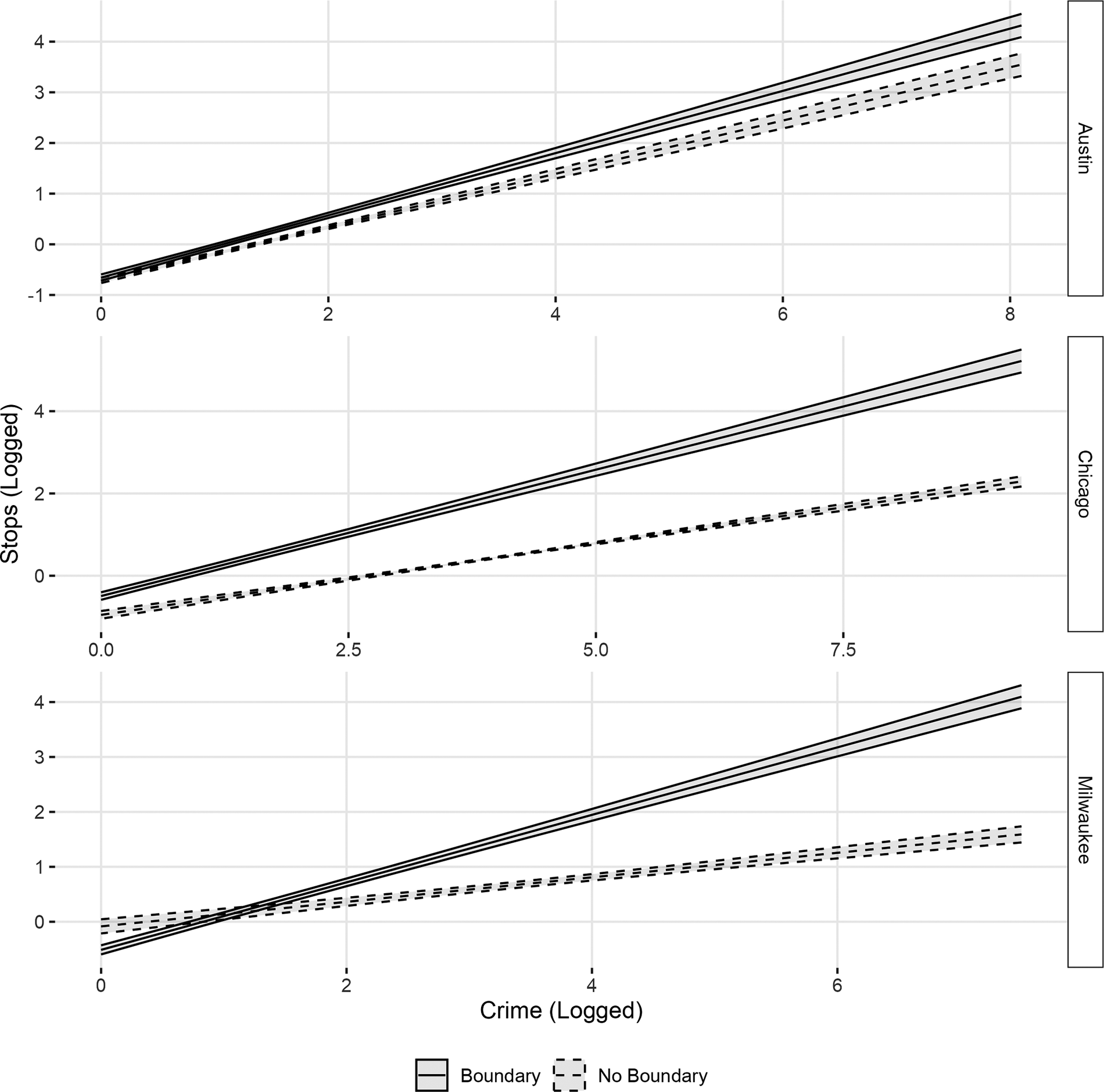
Figure 5 Influence of Logged Crime on Logged Police Stops (Standardized), Conditional on Racial Boundary Status
In sum, in six out of seven cities for which we have some kind of data we observe patterns that suggest crime in racial boundary zones receives excess attention from police relative to crime in non-boundary zones. While the evidence across cities at first appears mixed, we attribute this variation largely to differences in the kind of data available to us, where arrests of any kind, but especially felony arrests, are a conservative test of our overall theory. As we are able to leverage data (in this case police stops) that more precisely maps onto our theory, findings across cities become increasingly consistent. Only in Atlanta (where we lack stop data) do we fail to observe patterns consistent with the expectation that crime in boundary zones will receive more attention from police than crime in non-boundary zones. Overall, the preponderance of evidence available to us supports Hypotheses 1 and 2. Scholars elsewhere have argued that boundary zones are points of inter-group conflict which leads to elevated interpersonal violence and crime. The findings presented here suggest that boundary zones receive heightened attention from police that exceeds observed crime, pointing to the central role for police in maintaining racial segregation and inequality in urban spaces.
Assessing Racialized Policing in Boundary Zones
Hypotheses 3 and 4 concern the racialized distribution of police activity in racial boundary zones. Hypothesis 3 posits that heightened police activity observed in racial boundary zones will be apparent on both sides of the boundary. On one hand, we can imagine that policing might predominate on the non-white side of the line in an effort to control non-white populations, and that this reflects over-policing of non-white people in general. On the other hand, researchers have demonstrated that white individuals living in boundary zones make heightened requests for government intervention out of a sense of threat (Legewie Reference Legewie2018). We do not contest the citizen-driven factors that contribute to over-policing in boundary zones, but we do contend that top-down processes are essential to understanding how boundary zones organize police behavior. It should by now be clear that police activity does not simply follow crime, but that it is distributed in ways that reflect beliefs about how best to maintain social order and which spaces are vulnerable to the breakdown of order. Those beliefs are baked into the institutional policies and practices that govern, constrain, and organize police activity. As such, the disparate application of policing, whether racial, spatial, or otherwise, can occur in the absence of individual prejudices. We therefore expect that heightened police activity in boundary zones will be apparent on both sides of the boundary. We argue that the racialized nature of policing, in this case, manifests in heightened attention paid to racial boundary zones themselves, relative to racially homogeneous spaces.
In order to assess where arrests are most likely to occur, we interact percent white with the racial boundary metric. This allows us to assess whether arrests are more likely to occur in or out of boundary zones, conditional on percent white. The results are displayed in figure 6 (associated regression estimates are located in appendix table 10 and appendix table 11). In Boston and Chicago, it appears that in non-white spaces, there is no difference in the likelihood of arrest in boundary zones relative to non-boundary zones, but in white spaces risk of arrest is heightened in boundary zones. On balance, however, it appears that rather than moderating the effect of living in a non-white space on the risk of arrest, there is an intercept effect whereby one is more likely to face arrest in boundaries than in non-boundaries, even as non-white spaces—in or out of boundary zones—experience more policing overall than do white ones.Footnote 8 We repeat this analysis in Louisville among felony arrests (displayed in appendix figure 8 and appendix table 14), and in Austin, Chicago, and Milwaukee using stop data (located in appendix figure 10 and appendix table 17). The substantive takeaway, that heightened risk of arrest is higher in boundary zones for both white and non-white spaces, holds.
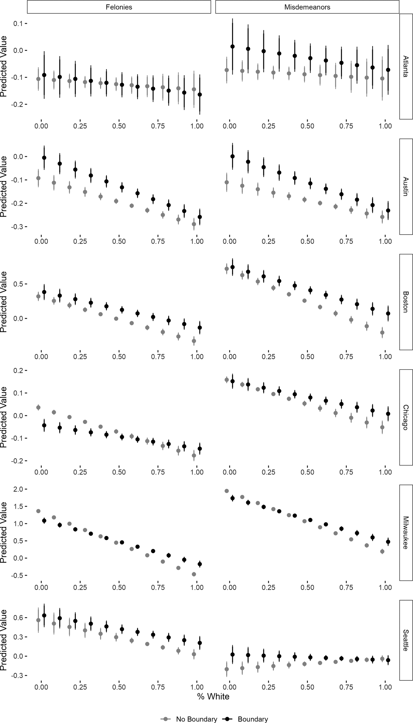
Figure 6 Heterogenous influence of racial boundary on arrests by white racial context
Notes: X-axis is the percent white measure. Y-axis is the predicted logged number of arrests (+1 to ensure identification), by arrest type. Each row characterizes a different city sample. Estimates from fully-specified models with controls at means. 95% CIs displayed from HC2 robust block group clustered SEs.
Hypothesis 4 concerns the race of civilian subject to police intervention. We have argued that top-down policies and procedures that determine the distribution of police resources are an important mechanism underlying the correlation between racial boundary zones and police activity. Other factors that also contribute to this relationship include demand-side factors, where white citizens request police intervention at higher rates in diverse spaces than in white, homogenous ones out of feelings of threat. Indeed, one study observed that in boundary zones non-white individuals were stopped more often on the white side of the boundary. However, again as earlier, police do not only respond to requests for service, they are first and foremost provided training around how to identify signs of potential criminality and given directives about where and how to patrol. One such heuristic that officers may draw on to identify the likelihood that an individual intends to commit crime is the fish-out-of-water heuristic. A fish out of water is an individual who appears to be in a neighborhood where they do not belong. The supply-side model of racially disparate policing predicts that individuals in boundary zones should be at greatest risk for police intervention when they are on the side of the boundary that contrasts with their race, and further that this should be true not just for non-white individuals in white spaces, but for all individuals when their race mismatches their surroundings. That is not to say that non-white people who are out of place face risk of arrest that is equal to white people who are out of place—non-white people are likely to face greater risk of arrest overall than are their white counterparts. Instead, both white and non-white people will face heightened risk of arrest when out of place in boundary zones than when in place and in boundary zones. The critical comparison is to other members of one’s racial group.
Only our data on police stops in Austin, Chicago, and Milwaukee includes the race of the civilian involved in a given interaction with police. We therefore leverage this data to evaluate the likelihood of being stopped among subsamples of white and non-white civilians, conditional on boundary status and racial composition of neighborhood.Footnote 9 The results of this analysis are displayed in figure 7 (the associated regression estimates can be found in appendix table 18). In Austin, both white and non-white individuals are more likely to be stopped when in boundary zones irrespective of which side of the line they are on. In Chicago and Milwaukee we observe that the fish-out-of-water heuristic is operative for both white and non-white individuals as within boundary zones, they face a heightened risk of arrest when they appear out of place on the basis of race. On balance, we take this as supportive evidence for our fourth hypothesis.
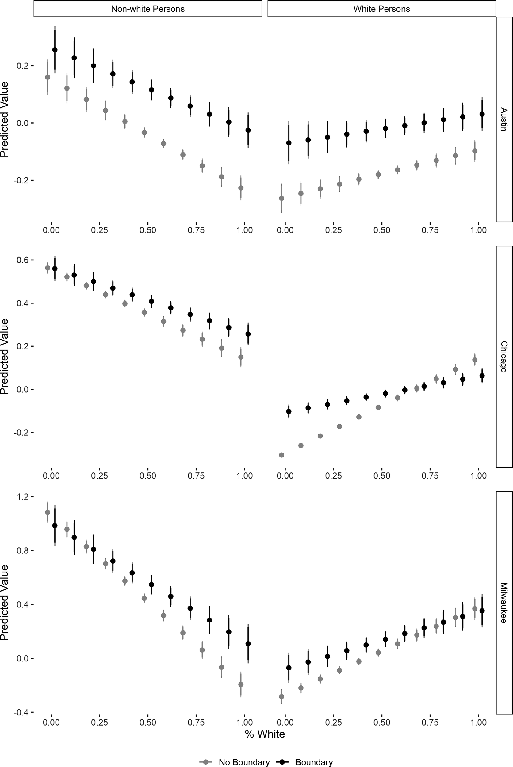
Figure 7 Heterogenous influence of racial boundary on police stops by race of civilian
Notes: X-axis is the percent white measure. Y-axis is the predicted logged number of police stops, by race of civilian stopped. Each row characterizes a different city sample. Estimates from fully-specified models with controls at means. 95% CIs displayed from HC2 robust block group-clustered SEs.
There is variation across cities in terms of how racialized policing expresses itself vis-à-vis boundaries. Hypothesis 3 anticipates that the probability of arrests will be higher in boundary zones than in non-boundary zones irrespective of which side of the boundary one is on. We do observe some differences in risk of arrest between boundary and non-boundary zones conditional on percent white, but which side of the line receives more attention from law enforcement differs by city. With respect to Hypothesis 4, we consistently observe that both white and non-white people are more likely to be stopped when they are racially out-of-place in boundary zones than when in non-boundary zones. Here, we leverage more sensitive data in the form of stops of civilians, but we only have this data for three of six cities. For this reason, it is difficult to make sense of inter-city heterogeneity on these points. Setting data differences aside, these heterogeneous patterns highlight that policing is fundamentally a local phenomenon. We have argued that police departments broadly embrace a style of policing that gives officers discretion, instructs them how to preempt crime, that doing so is a fundamental task of police work, and that policing racial boundaries is part-and-parcel to the task of maintaining social order. We think we have offered evidence that is sufficiently consistent to support that argument. Nevertheless, that there is some heterogeneity across contexts highlights the importance of cross-city approaches (as we have done here), and the ongoing need for scholars to verify and validate their theories outside of a single city, an approach that continues to define much of modern policing scholarship.
Conclusion
This article evaluates the role that police play in regulating and maintaining racial segregation in the United States. Where scholars elsewhere have paid a great deal of attention to the impact of segregation on downstream outcomes like welfare service provision and the distribution of law enforcement resources, this research primarily attends to differences among racially homogeneous communities, without attention to the places where those communities meet. Here, we turn attention to racial boundary zones, where white and wealthy enclaves abut poor and non-white ones. Sociologists have begun to examine the geopolitics of these spaces, giving special attention to the dynamics of public safety. Positioning them as sites of inter-group conflict, some scholars have argued that racial boundary zones feature diminished social cohesion, out-group animus among the relatively privileged, and in turn, have empirically observed elevated crime and heightened requests for police intervention among racially threatened white citizens in boundary zones (Dean et al. Reference Dean, Dong, Piekut and Pryce2019; Legewie and Schaeffer Reference Legewie and Schaeffer2016; Kramer Reference Kramer2017; Legewie Reference Legewie2018; Kim and Hipp Reference Kim and Hipp2022).
Research addressing the politics of racial boundaries in American cities is nascent. Even as scholars have long recognized the role that police play in upholding social stratification, systematic evaluations of police activity in boundary zones have focused on the inability of private citizens to get along. Privileged white people deploy the police against subordinate non-white groups in an effort to regulate access to their space. Heightened crime in border zones is reflective of degraded social cohesion that results from intergroup conflict. Individual citizens are cast as central architects of racial inequality in these spaces. This citizen-centric account overlooks policies and practices that organize police behavior around maintaining a particular social order and supporting patterns of investment and consumption. Smith (Reference Smith2005) refers to race and class boundary zones as new frontiers ripe for gentrification, where border zones are particularly likely to yield profit for investors. To wit, researchers note that processes of gentrification are most likely to occur in non-white neighborhoods adjacent to already invested white ones, rather than in deeply segregated neighborhoods far from vibrant economic zones (Hwang and Sampson Reference Hwang and Sampson2014). Policing, moreover, is deployed to support these patterns of investment (Beck Reference Beck2020; Laniyonu Reference Laniyonu2018). Thus, an account of the politics of racial boundary zones that focuses on the behavior of private citizens is incomplete, and a full understanding of these spaces requires attention to the institutional features by which they are shaped.
Scholars elsewhere leverage ethnographic methods to offer a thick description of police practices in one city, turning the focus to the top-down processes by which law enforcement resources are organized in and around boundary zones (Gordon Reference Gordon2022). Gordon’s account provides necessary theory of the institutional processes at play that yield increased attention by law enforcement to boundary zones. Research focused on the demand-side factors for police presence in racial boundary zones develops an innovative, data-driven metric for detecting organic racial boundaries, and compelling evidence from two cities that boundaries matter to the citizens who inhabit them, but their account is incomplete. This article provides a necessary link between the theoretical foundation laid by Gordon (Reference Gordon2022) and the empirical innovations developed by scholars interested in public safety in these same spaces.
Our primary goal, then, is to reorient the empirical study of racial boundary zones around the state-centric processes that regulate these spaces. We accomplish this by decoupling, to the extent possible, policing and crime, and evaluate whether crime in racial boundary zones receives excessive attention from police relative to crime outside boundary zones. We do not contest that inter-group conflict and feelings of out-group threat work to promote heightened policing in boundary zones as a consequence of civilian requests for intervention. Instead, we argue that civilian-side processes co-occur with agency-side ones to produce heightened state intervention in racial boundary zones. Moreover, we wished to evaluate whether patterns of policing in and out of racial boundary zones are a feature of contemporary practices employed by lots of different departments across the country, rather than an artifact of agency idiosyncrasies in one or two cities. In order to do this, we collected data on police activity and crime for seven municipalities across the United States, alongside relevant neighborhood demographics. Following Legewie (Reference Legewie2018), we develop a metric of racial boundary zone status at the block level drawing on Census demographic data, which we then bring together with high resolution incident level data on crime, arrests, and stops in order to evaluate the impact of boundaries on police activity. In all, we compiled a dataset of police activity that is uniquely broad, while also achieving a level of richness and depth typically only feasible in single-city case studies.
We argue the everyday policies and practices engaged by police, which are themselves laden with race and class biases about value, worth, and criminality, are central to explaining the distribution of law enforcement in cities, and as such, police activity does not strictly adhere to crime. Instead, efforts to regulate access to and movement between invested and disinvested spaces yield heightened activity in the transitional zones between disparate communities, relative to racially homogeneous enclaves. The central proposition that follows from this argument is straightforward: crime in racial boundary zones receives more attention from police than does crime in non-boundary zones. We further expected these dynamics to be most apparent in police activity arising from low-level infractions, which reflect police discretion in ways that more serious (violent) offenses do not. Finally, because race is centrally regulated by law enforcement through space, we anticipate that heightened police activity will be apparent in boundary zones, irrespective of which side of the boundary one is on, and against both white and non-white individuals who appear to be on the wrong side of the line. This can be true even as white civilians living in boundary zones make heightened requests for police intervention in order to regulate their non-white neighbors, as scholars have found elsewhere (Legewie and Schaeffer Reference Legewie and Schaeffer2016; Neil and Legewie Reference Neil and Legewie2023). Drawing on an array of data and tests, we find support for each of our specified hypotheses. Overall, we offer evidence that demand-side factors are likely insufficient to explain heightened police activity in boundary zones—top-down processes coalesce with citizen-driven ones to promote and maintain racial segregation in American cities.
Our analysis is not without limitations. Lack of sufficient data over time prohibits an evaluation of how changing boundaries impact police distribution of resources. Likewise, we cannot distinguish between police activity that results from officer discretion from that which results from civilian demand, we are only able to observe patterns consistent with the idea that top-down factors significantly shape officer behavior. We do not wish to adjudicate between top-down and bottom-up models of policing in boundary zones, but we can imagine locational 911 call data that might allow the researcher to distinguish between officer and civilian initiated activity, which in turn would facilitate a descriptive assessment of the composition of calls in and out of boundary zones. We were not able to obtain data to facilitate this kind of analysis. Even so, this project offers the broadest analysis to date of police activity in and out of boundary zones, with data that is also sufficiently granular to allow for a precise estimation of how police interact with and regulate spaces where racial groups collide. We offer descriptive evidence supportive of the theoretical proposition that institutional policies and practices contribute to the production and maintenance of racial segregation in American cities.
We begin an evaluation of the politics of racial borders in urban spaces with a focus on policing and crime. We enter into conversation with scholars interested in boundary zones as a socio-political feature that reflects intergroup conflict that implicates public safety. Our effort is to recast boundary zones as products of political processes, rather than interpersonal ones. While questions of policing have provided entry into a study of racial boundary zones, the argument forwarded here implicates far more than questions of public safety. As organizing features in American cities, much work remains to understand the no doubt complex web of disparate policies that calcify borders between communities and the politics produced by said borders. How do processes of gentrification map on to racial boundary zones? Under what conditions do race and class diversity produce greater empathy versus animus? Why and under what conditions do individuals violate racial boundaries? How do denizens of racial boundary zones differently leverage the government to get their needs met, and do said denizens view their interests as shared or conflicted? We recenter institutional processes in the political milieu that characterizes racial boundary zones and lay the necessary groundwork for future research on the politics these spaces produce.
Supplementary material
To view supplementary material for this article, please visit http://doi.org/10.1017/S1537592725000490.
Data Replication
Data replication sets are available in Harvard Dataverse at: https://doi.org/10.7910/DVN/LLRHWU


 Open access