Coastlines worldwide are coming under increasing pressure due to climate change and human activity. Data on shoreline change are essential for coastal managers and when no long-term monitoring programs are implemented and shoreline change is typically on the order of less than 1 m/yr., as observed in Ireland, aerial photography is the most valuable source of information. A well-established literature exists for automated vegetation extraction from digital images based on the near infrared reflectance, but there is less research available on spectrally limited colour photography. This study develops a methodology for automating vegetation line extraction from a series of historical aerial photography of the Cork coastline in the South-West of Ireland. The approach relies on the Normalised Green–Blue Difference Index (NGBDI), which is versatile enough to discriminate disparate coastal vegetation environments, at different resolutions and in various lighting and seasonal conditions. An iterative optimal threshold process and the use of LiDAR ancillary datasets resulted in an automated vegetation line measurement with uncertainties estimated to be between 0.6 and 1.2 m. Change rates derived from the vegetation lines extracted present uncertainties in the range of ±0.27 m/yr. This robust and repeatable method provides a valuable alternative to time-consuming and subjective manual digitisation.
Refine listing
Actions for selected content:
Contents
Research Article
Automating the quantification of coastal change using historical aerial photography: A case study along the coastline of county Cork, Ireland
-
- Published online by Cambridge University Press:
- 10 December 2024, e1
-
- Article
-
- You have access
- Open access
- HTML
- Export citation
Research Article
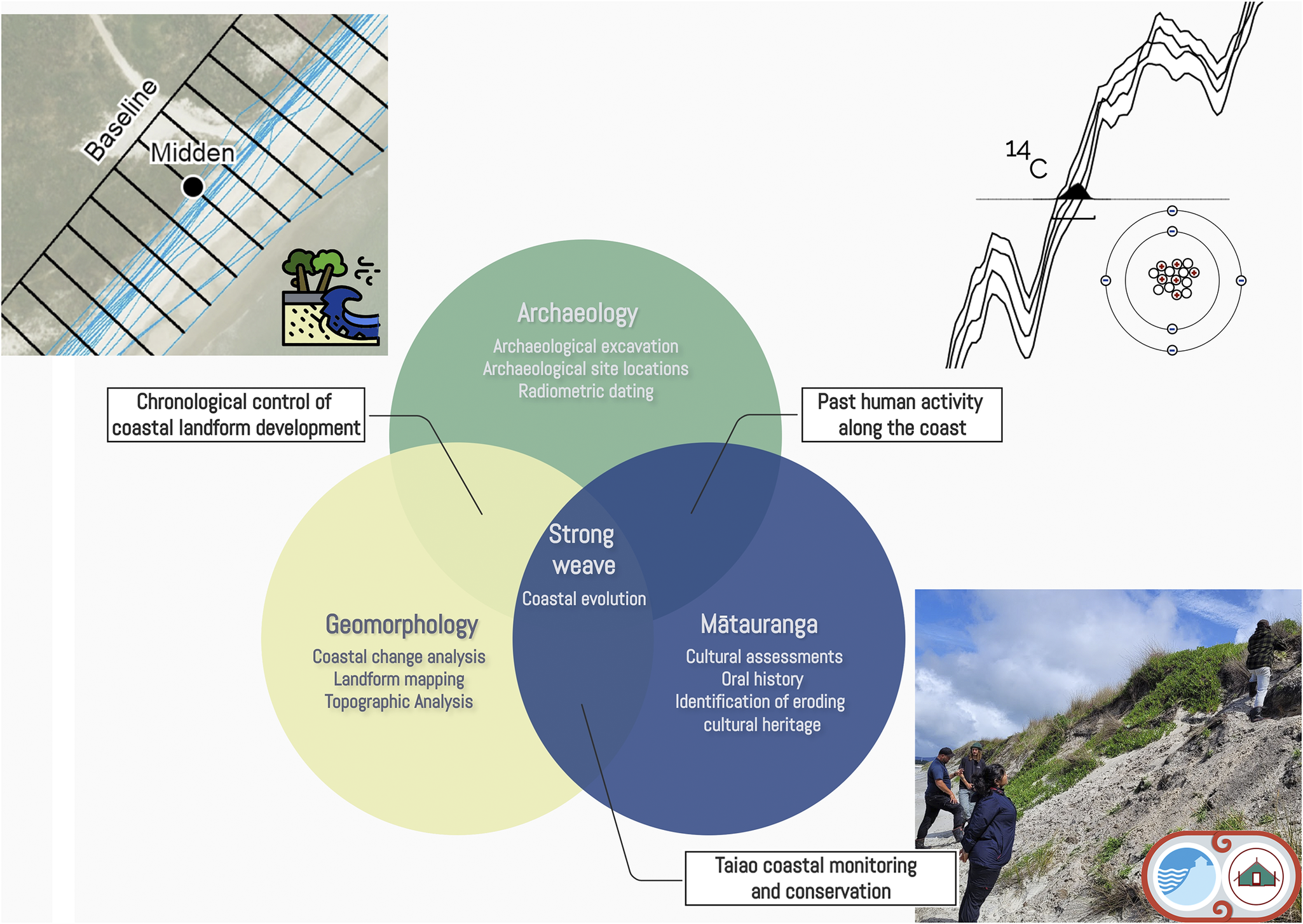
Braiding archaeology, geomorphology and indigenous knowledge to improve the understanding of local-scale coastal change
-
- Published online by Cambridge University Press:
- 20 December 2024, e2
-
- Article
-
- You have access
- Open access
- HTML
- Export citation
Research Article
Solvable constraints and unsolvable limits to global climate adaptation in coastal Indigenous food security
-
- Published online by Cambridge University Press:
- 24 January 2025, e3
-
- Article
-
- You have access
- Open access
- HTML
- Export citation
Research Article
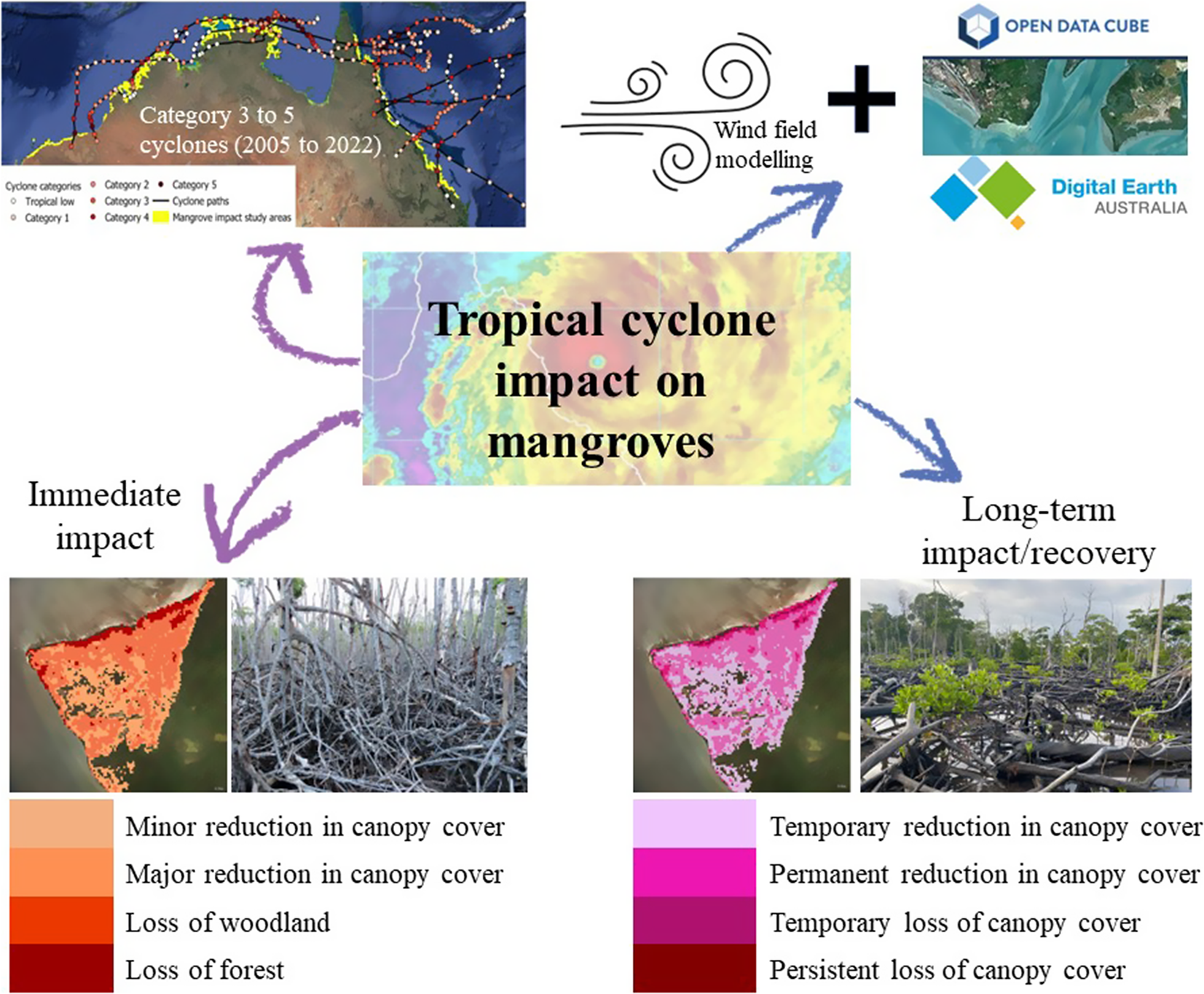
Characterising the short- and long-term impacts of tropical cyclones on mangroves using the Landsat archive
-
- Published online by Cambridge University Press:
- 20 December 2024, e4
-
- Article
-
- You have access
- Open access
- HTML
- Export citation
Rapid Communication
Global complexities and challenges in the restoration of hypersaline coastal wetlands
-
- Published online by Cambridge University Press:
- 23 January 2025, e5
-
- Article
-
- You have access
- Open access
- HTML
- Export citation
Perspective
Science diplomacy and the 5th International Polar Year (IPY-5): planetary considerations across centuries
-
- Published online by Cambridge University Press:
- 24 January 2025, e6
-
- Article
-
- You have access
- Open access
- HTML
- Export citation
Perspective
From flood forecasts to rapid assessments of risk and impacts: Establishing operational modelling frameworks for coastal flood management at the German Baltic Sea coast
-
- Published online by Cambridge University Press:
- 07 February 2025, e7
-
- Article
-
- You have access
- Open access
- HTML
- Export citation
Research Article
Spectral analysis for monitoring mangrove restoration: A case study in the Vietnamese Southern Coastline
-
- Published online by Cambridge University Press:
- 28 March 2025, e8
-
- Article
-
- You have access
- Open access
- HTML
- Export citation
Research Article
Balancing conservation and human access to nature: the impact of a constructed causeway on water levels and sedimentation, North Bull Island, Ireland
-
- Published online by Cambridge University Press:
- 04 April 2025, e9
-
- Article
-
- You have access
- Open access
- HTML
- Export citation
Research Article
Monitoring climate change impacts, Indigenous livelihoods and adaptation: Perspectives from Inuit community of Hopedale, Nunatsiavut, Canada
-
- Published online by Cambridge University Press:
- 14 April 2025, e10
-
- Article
-
- You have access
- Open access
- HTML
- Export citation
Erratum
Balancing conservation and human access to nature: the impact of a constructed causeway on water levels and sedimentation, North Bull Island, Ireland – ERRATUM
-
- Published online by Cambridge University Press:
- 30 May 2025, e11
-
- Article
-
- You have access
- Open access
- HTML
- Export citation
Research Article
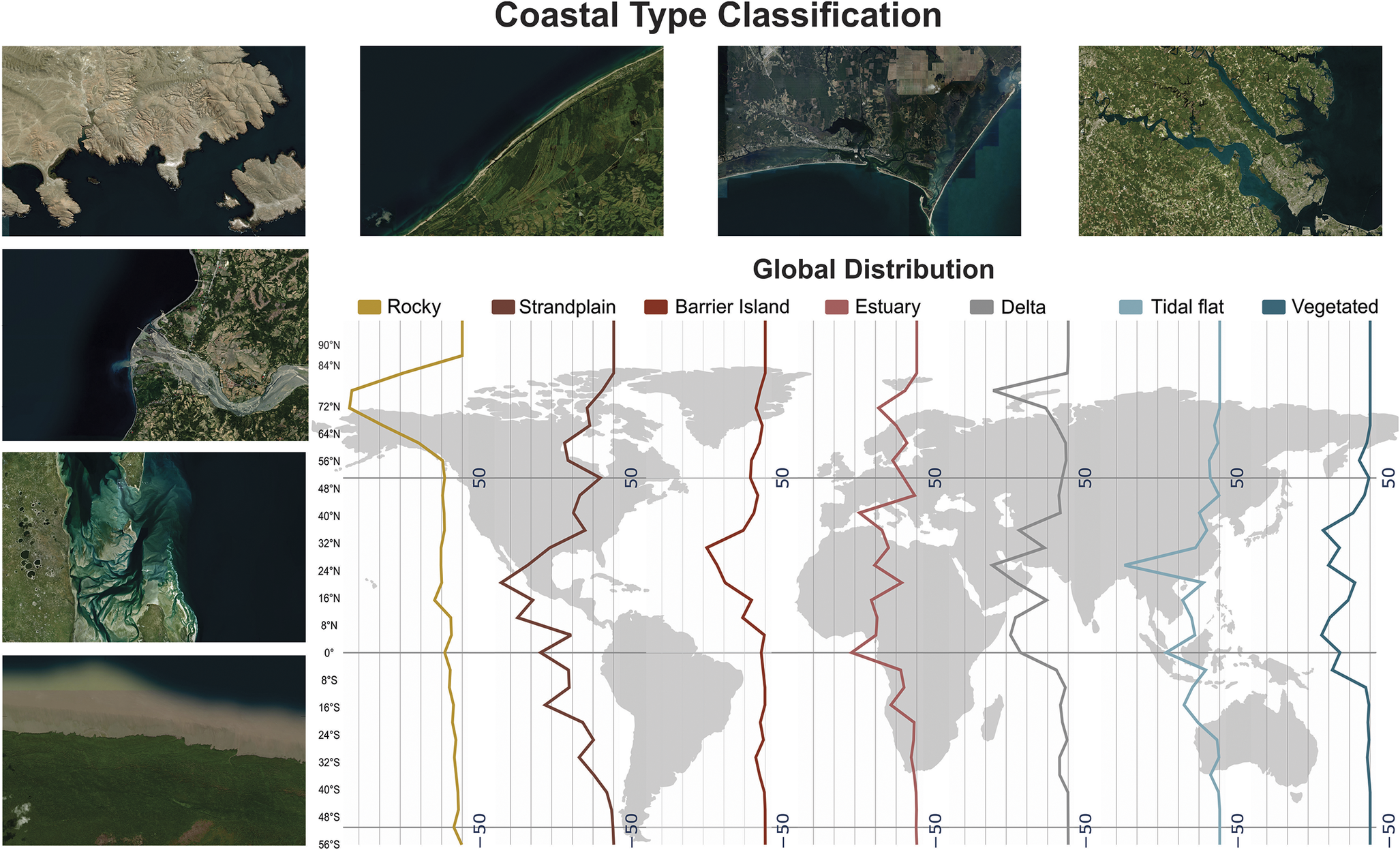
Global coastal exposure patterns by coastal type from 1950 to 2050
-
- Published online by Cambridge University Press:
- 16 June 2025, e12
-
- Article
-
- You have access
- Open access
- HTML
- Export citation
Review
An integrated view on the uncertainties of sea-level rise, hazards and impacts, and adaptation
-
- Published online by Cambridge University Press:
- 16 June 2025, e13
-
- Article
-
- You have access
- Open access
- HTML
- Export citation
Research Article
The power of learning from the bottom up: working towards a blueprint for community-led biodiversity protection and restoration
-
- Published online by Cambridge University Press:
- 18 June 2025, e14
-
- Article
-
- You have access
- Open access
- HTML
- Export citation
Overview Review
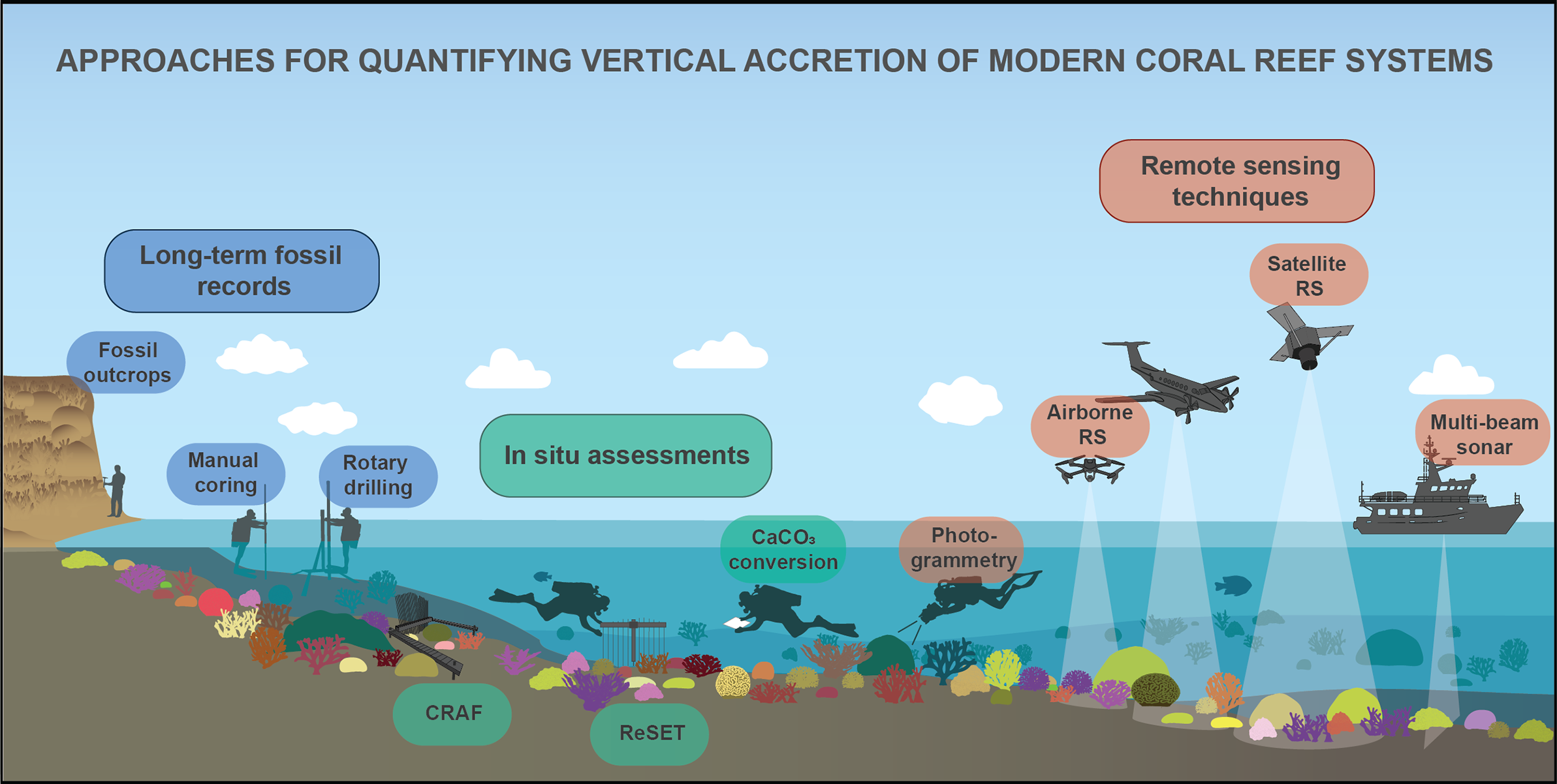
Quantifying coral reef accretion in a changing world: approaches, challenges and emerging opportunities
-
- Published online by Cambridge University Press:
- 27 June 2025, e15
-
- Article
-
- You have access
- Open access
- HTML
- Export citation
Erratum
The power of learning from the bottom up: working towards a blueprint for community-led biodiversity protection and restoration – ERRATUM
-
- Published online by Cambridge University Press:
- 02 July 2025, e16
-
- Article
-
- You have access
- Open access
- HTML
- Export citation
Research Article
Global analysis of temporal clusters of storm surges
-
- Published online by Cambridge University Press:
- 01 August 2025, e17
-
- Article
-
- You have access
- Open access
- HTML
- Export citation
Overview Review
Coastline changes: A reconsideration of the prevalence of recession on sandy shorelines
-
- Published online by Cambridge University Press:
- 22 August 2025, e18
-
- Article
-
- You have access
- Open access
- HTML
- Export citation
Case Study
Voices from Akplabanya: Community adaptation and social-ecological changes in coastal Ghana
-
- Published online by Cambridge University Press:
- 03 September 2025, e19
-
- Article
-
- You have access
- Open access
- HTML
- Export citation
Research Article
From perception to modelling: Nature-based solutions as a tool for coastal risk management
-
- Published online by Cambridge University Press:
- 22 August 2025, e20
-
- Article
-
- You have access
- Open access
- HTML
- Export citation


