


Introduction
Prior to their mid-fifteenth-century discovery, the uninhabited Cape Verde Islands, some 500km west of Africa (Figure 1), had no indigenous population and only very restricted flora and fauna. As a ‘place of arrivals’, its colonial impacts are therefore distinct.

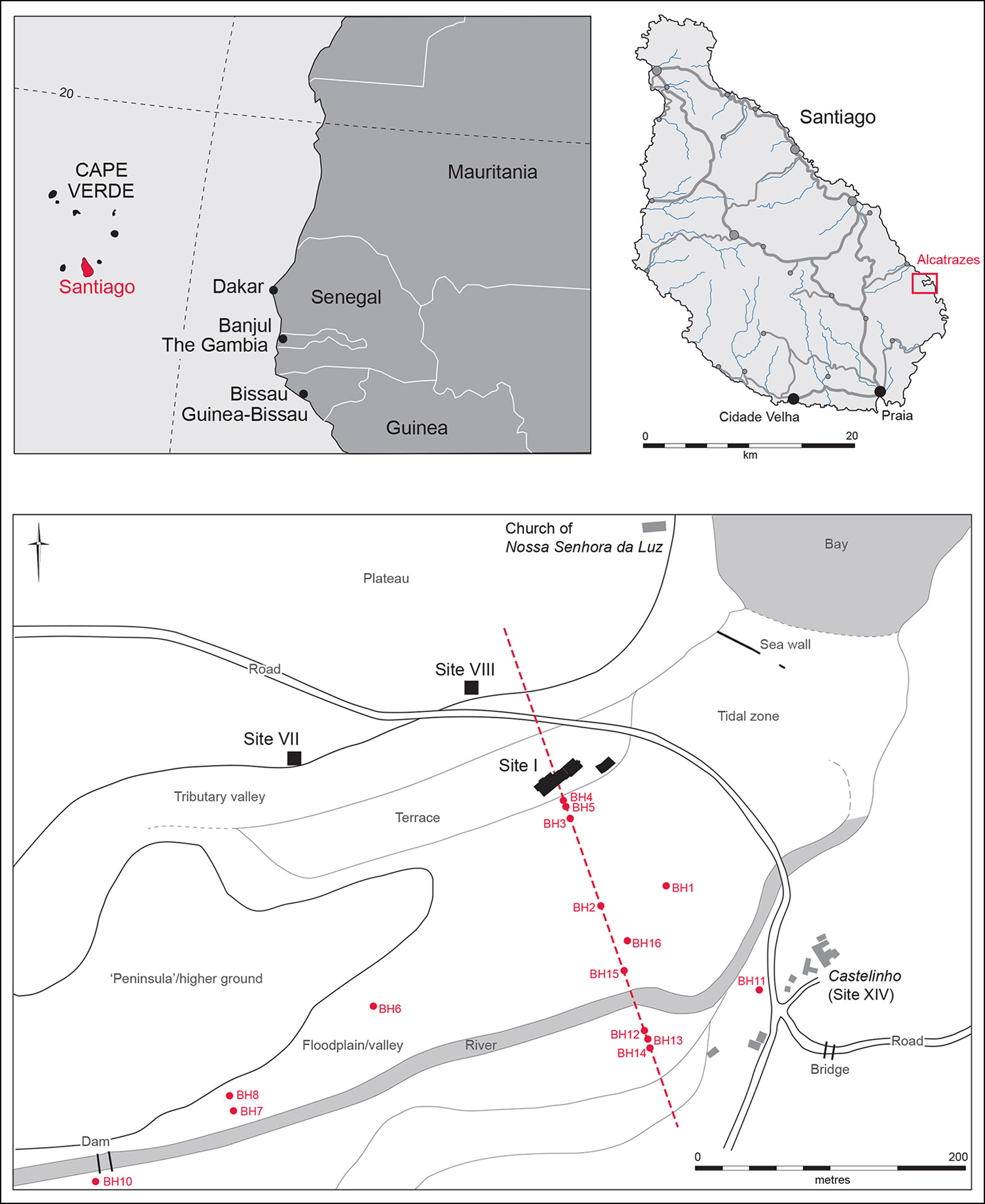
Figure 1. Location map, red-line indicates cross-valley geoarchaeological transect (figure by A. Hall).
Alcatrazes, the short-lived seat of the ‘failed’ second governing captaincy (AD 1484–1516) on Santiago’s east coast, was effectively ‘lost’ and the actual location of its settlement only identified in 2012 through field survey (Evans et al. Reference Evans2017). Here, we focus on the excavation of the main Site I settlement (Figures 1 & 2), undertaken by the University of Cambridge and the Cape Verdean Ministry of Culture/Instituto do Patrimonio Cultural (with colleagues from the Universities of Lisbon, Stirling and Tenerife), which is deepening insights into early slave trade-based colonialism.

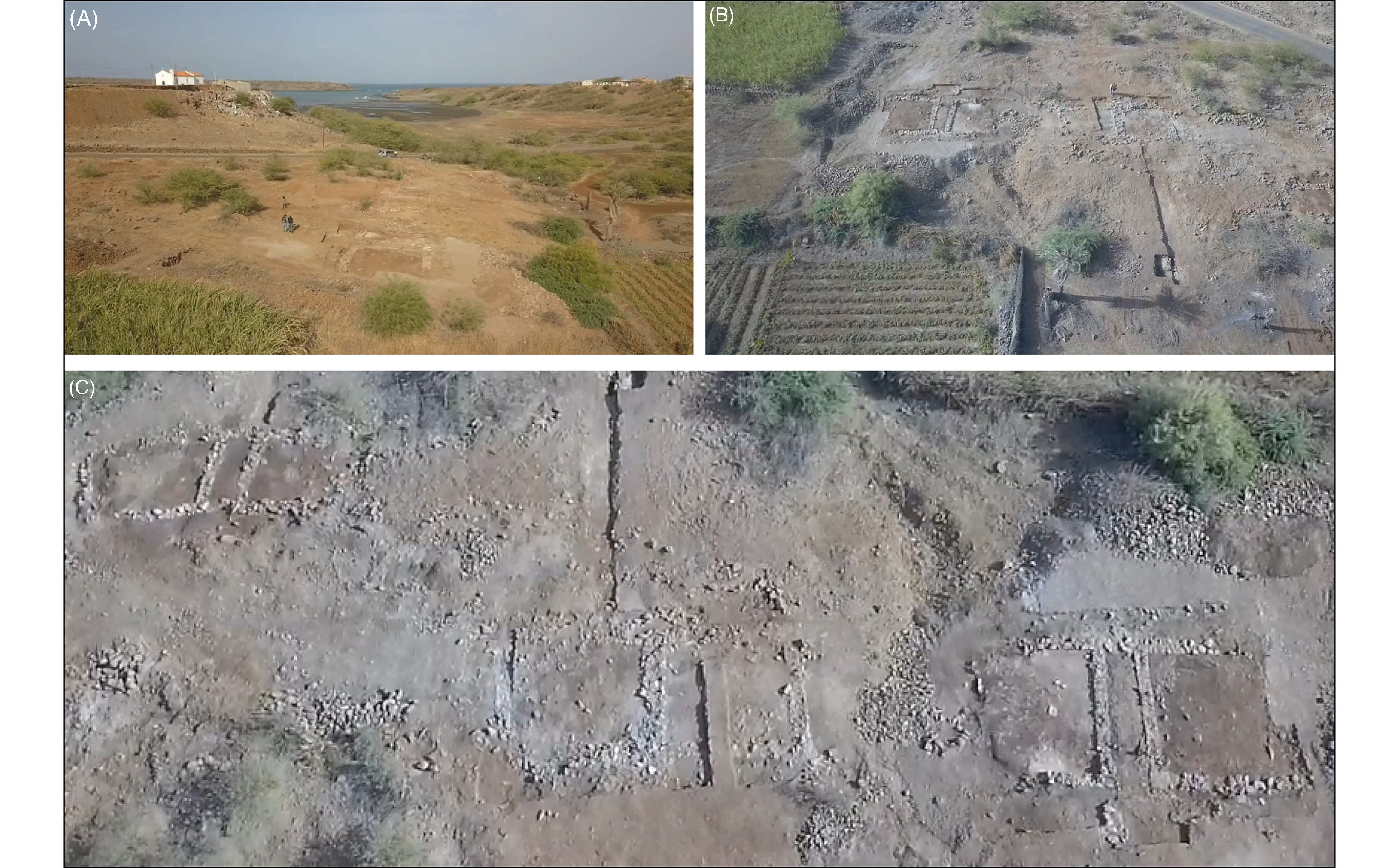
Figure 2. The low-valley terrace situation of Site I: A) looking north-east with the Gothic church atop the plateau; B) looking north to the site; C) the main building axis (facing south) (figure by Municipality of San Domingos).
The settlement
The small, squarish buildings of Alcatrazes contrast with later depictions of Ribeira Grande, today’s Cidade Velha. Ribeira Grande was Santiago’s first captaincy and original capital, which became a world slave-trade entrepôt in the sixteenth century. Early prints show the dense, quasi-European fabric of Ribeira Grande, its many churches, Cathedral, seafront batteries and fort (e.g. Sørensen et al. Reference Sørensen, Evans, Richter., Lane and MacDonald2011). Despite deep strata, excavations there have revealed little of its origins, while the sequence at Alcatrazes provides evidence of a settler community’s foundation.
Rather than a failed settlement, Alcatrazes shows a ‘demise’. Official offices were relocated to Praia in 1516, but pottery indicates that occupation continued into the next century. Even thereafter, as attested by church burials and dispersed Luso-African settlements, people clearly remained in the vicinity.
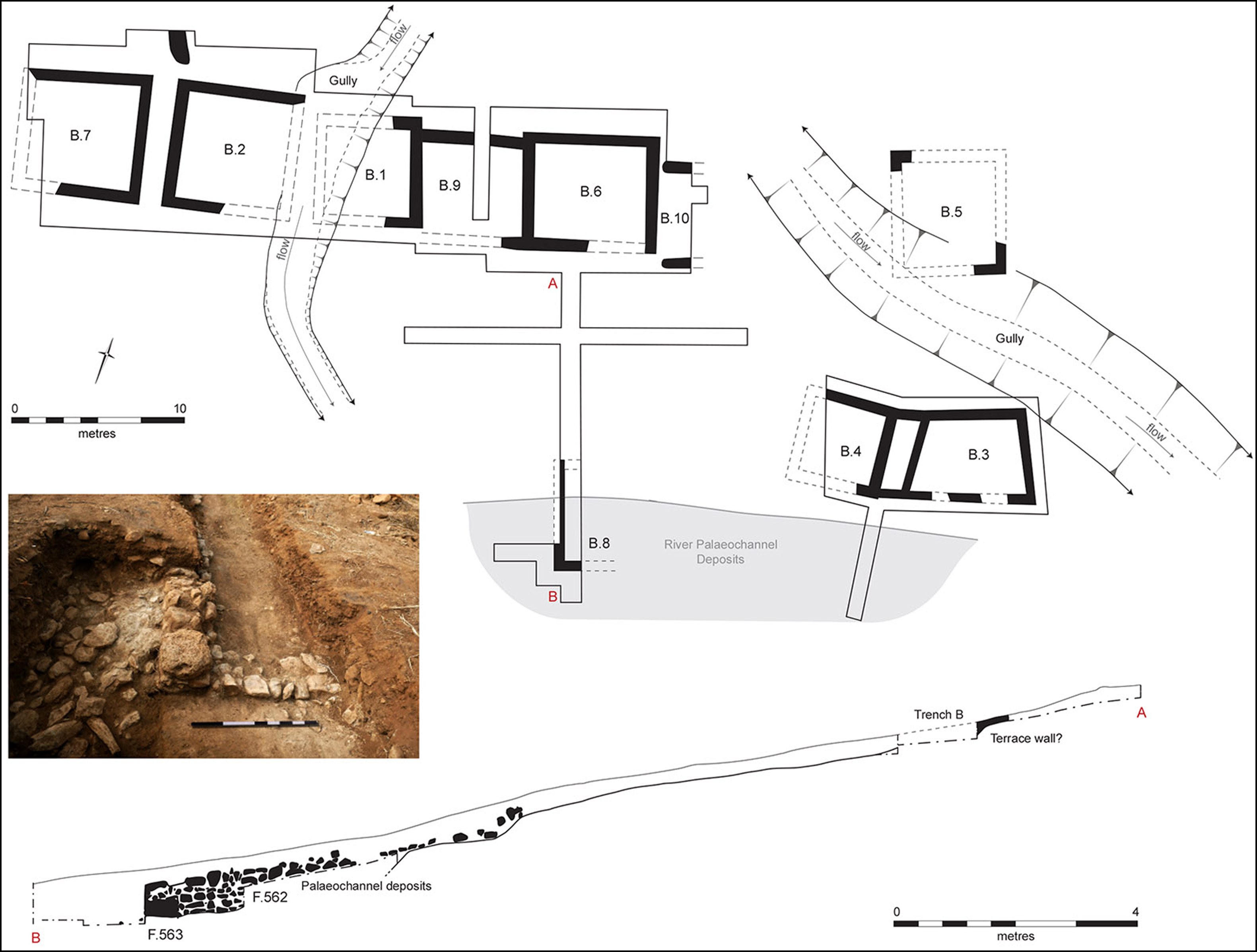
The settlement lies on a lower valley terrace alongside a palaeochannel that was active at the time of occupation. Aside from one structure beside the river (B.3/4)—possibly a warehouse—masonry-built houses were arranged in a line, and seven have been exposed so far (Figure 3). Traces of a cobbled street and the remains of a waterfront dock have also been recovered. The modest scale of the buildings would, in part, have been determined by the types of imports: both timbers—determining roof spans—and lime mortar (Figure 4). Associated material culture (e.g. pottery, see below) and finishing (i.e. plastered wall-cover) indicate that these buildings were the abodes of European residents. However, the households would have included enslaved persons. Five spindle whorls—one probably of African origin (Figure 5)— suggest ‘cottage-scale’ production of pano textiles known as a basis of barter in the West African trade.

Figure 3. Site plan, with terrace-side section below and inset photograph of the riverside revetment (B.8) (figure by V. Herring & authors).

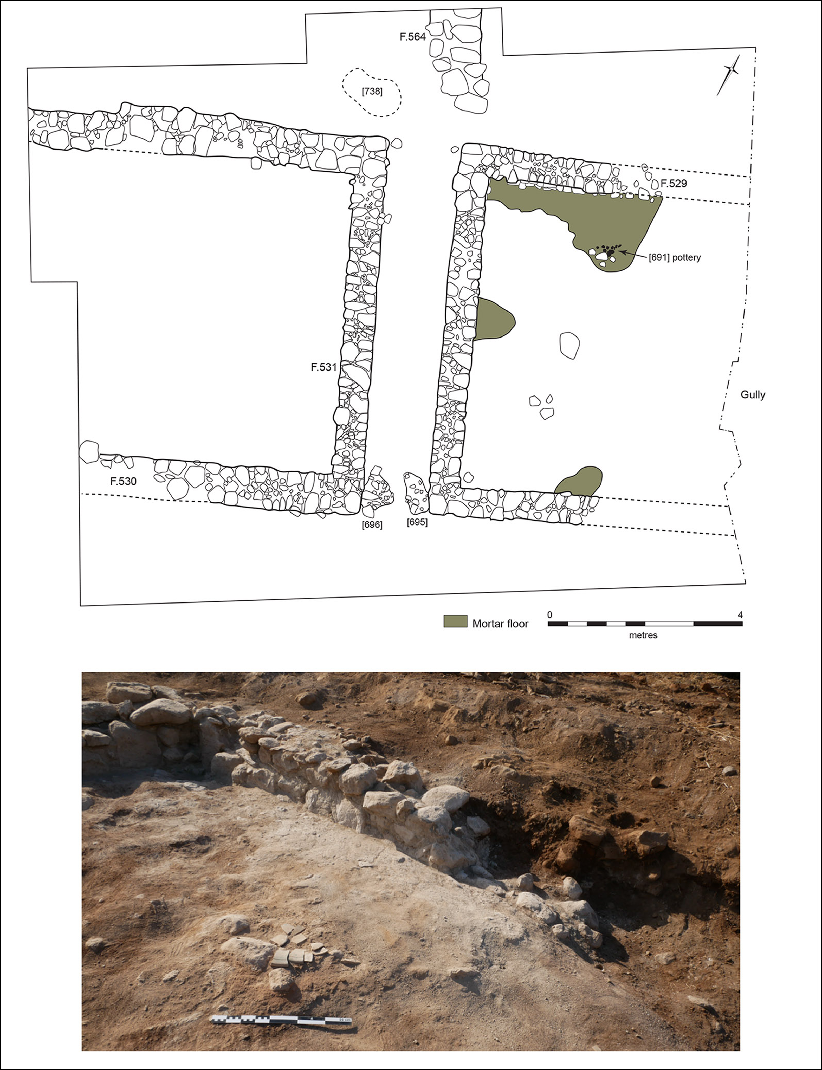
Figure 4. Plan of Buildings 2 (right) and 7 (left), with photograph of pottery on the latter’s floor surface below (figure by V. Herring & authors).

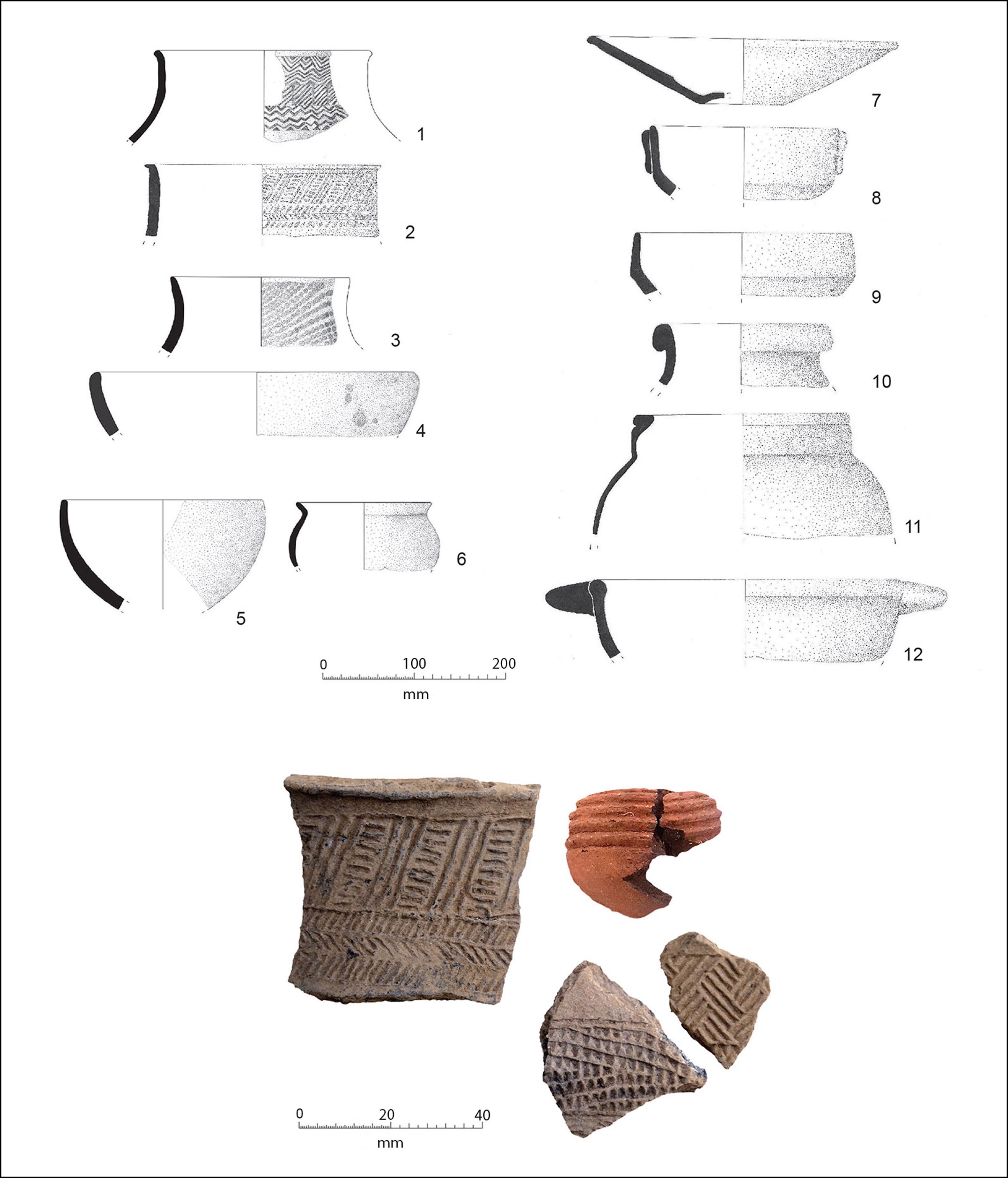
Figure 5. Site I pottery: 1–3) sherds from West African jars with roulette-decorated high necks; 4–6) Cape Verdean open bowls; 7–9) Iberian tin-glazed ware; 10–12) Portuguese redware cooking pot; below, examples of West African rouletted pottery and the probable African spindle whorl (lower image, upper right; figure by authors).
The buildings at Site I probably extend further. Documentary sources suggest that Alcatrazes involved 20–30 households and a population of around 200 (Richter Reference Richter2015). The structures currently exposed may be only a settlement ‘quarter’, with perhaps another along the valley’s southern side.
Significant arrivals
The basis of the town was trade. Of the 18 leading individuals named in documents, five were merchants with another five either ship-owners or mariners, four of whom directly engaged in the Guinean Coast slave trade. This interaction finds its clearest expression in pottery; the more than 3900-sherd assemblage includes wares from Portugal, West Africa and an emerging local pottery production (Figure 5). The bulk of the pottery is European (63%); largely dating between AD 1480 and 1550, it was produced primarily in Portugal, with a few Spanish imports. It reproduces European cultural models: the world from home was imported wholesale, from dinner plates to chamber pots. This encompasses redware wheel-made pots, including cooking vessels, water-related ceramics and other types (braziers and oil lamps), plus a few remarkable objects such as Estremoz quartz-inlaid cups. Glazed fabrics, such as green flared bowls, also occur alongside tin-glazed plates and bowls.
The rest of the pottery is relatively simple handmade forms. Based on distinct roulette decoration and shapes, the material divides into West African (10%) and Cape Verdean wares (22%). The long tradition of rouletted pottery in West Africa negates determination of the specific source and date of the jar and bag-shaped bowl sherds. These occur in contexts with early faience (AD 1480–1520) but rarely with later materials. Probably arriving on the ships from Africa, they may have been for onboard storage and, brought to Alcatrazes with the enslaved people, used for storage and cooking.
The Cape Verdean material is composed of a range of simple bowls and jars, either unadorned or decorated with pin-pricks or striations, as if imitating rouletting. These local wares show no influence from the Portuguese coarseware.
The settlement’s economy evinces a range of animal domesticates—cattle, goats and pigs (thus far, horses are absent)—augmented by shellfish and marine fish, including sharks, groupers and parrotfish. Initially, all the plant food must have been imported, but over time plants were introduced and local cultivation developed.
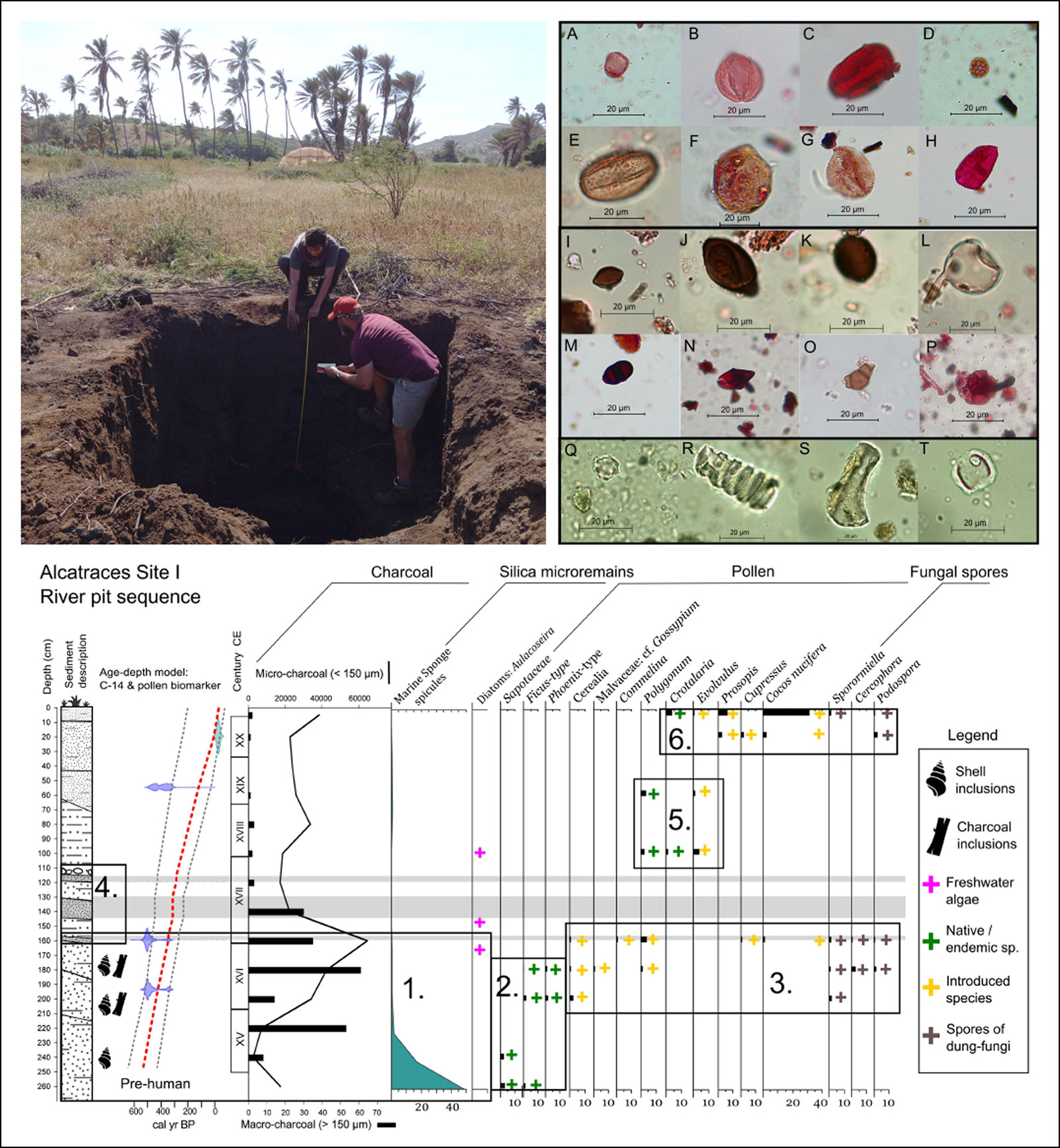
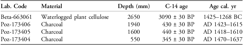
An environmental test pit (S1R) targeting an intertidal palaeochannel just south of the site, exposed a sedimentary sequence revealing landscape dynamics reflective of the Portuguese impact (Figure 6). Radiocarbon dating indicates that the basal unit is pre-colonial, with most of the subsequent deposits accumulating between AD 1400 and the present (see Table 1).

Figure 6. The S1R test pit, showing selected microfossils from profile sediments (A–H: pollen; I–P: non-pollen palynomorphs; Q–T: phytoliths) and, below, the sedimentology sequence and selected multi-proxy data (numbered panels show data-aggregates of different stages of landscape change; see text) (figure by authors).
Table 1. Radiocarbon dates (calibrated in OxCal using IntCal20 v4.4.4).

Pollen and phytoliths of herbaceous taxa dominate the sequence, indicative of an open coastal landscape with abundant herbs, small shrubs and coastal halophilous (salt-tolerant) vegetation. Four main phases chart the transformation of native coastal vegetation into a dynamic agricultural landscape. Phase I (2.7–2.2m) is organic-rich, estuarine materials reflective of an initial ‘braid-plain’ stage. The presence of pollen of native/endemic taxa shows the pre-colonial landscape, with Syderoxylon marginata, Ficus sp. and Phoenix atlantica (palm) trees (Figure 6, Panel 2). Phase II (2.2–1.6m) sees an increase of eroded material with charcoal relating to the initial settlement (Panel 1). Cerealia pollen grains, along with Malvaceae pollen (potentially cotton) and spores of dung-loving fungi (e.g. Sporormiella), suggest animal herding, landscape management and the introduction of economic species (Panel 3, 2–1.6m). Phase III (1.65–1.1m) encompasses eroded alluvial/colluvial material deposited during high-energy events (AD 1600–1700; Panel 4). Finally, Phase IV (<1.10m) is marked by humic brown/dark grey alluvium featuring agricultural weeds (e.g. Commelina, Crotalaria and Evolvulus: Panel 5), and introduced tree taxa (Cupressus), coconut palms (Cocos nucifera) and acacia (Prosopis; Panel 6).
The excavations at Alcatrazes provide a major counterpoint to the dominance of Ribeira Grande in the historical narrative of Cape Verde, documenting the islands’ initial colonisation and its many ‘arrivals’. Plans are progressing for the site’s conservation and display.
Acknowledgements
We acknowledge the co-operation and support of the Municipality of San Domingos and the Cape Verdean Ministry of Culture/Instituto do Patrimonio Cultural. The graphics attest to the skills of Andrew Hall and Vicki Herring.
Funding statement
The excavations were funded by the McDonald Institute for Archaeological Research. The environmental studies have been facilitated by Postdoctoral Grants FJC2020-043774-I and Margarita Salas Universidade de la Laguna (Spanish Government Ministerio de Universidades), and by a European Research Council TIME-LINES grant (ERC-CoG-2021-101045309).

 Open access