


Introduction
Ancient frontiers were dynamic landscapes shaped by the various motivations, interests and interactions of the diverse groups who lived within and beyond these boundaries (Lattimore Reference Lattimore1940; Naum Reference Naum2010). Physical barriers (e.g. walls, trenches and forts) often marked borders, serving both functional and symbolic purposes (Mullin Reference Mullin2011); they provided protection from invading armies and controlled the movement of people and goods, while simultaneously embodying the power and authority required to organise the resources and labour necessary to not only build, but also to monitor and maintain them. This is particularly true for ancient long walls, many of which still stand today (Shelach-Lavi et al. Reference Shelach-Lavi, Wachtel, Golan, Batzorig, Amartuvshin, Ellenblum and Honeychurch2020a).
An extended tradition of long-wall building, using earth, stone, wood and brick, can be observed in Asia. Among the many extant examples, the Medieval Wall System (MWS), a network of walls, trenches and associated enclosures built in the tenth–thirteenth centuries AD that spanned parts of China, Mongolia and Russia (Figure 1), is perhaps least well known. Since 2018, the European Research Council-funded project, ‘The Wall: people and ecology in medieval Mongolia and China’, has compiled historical and published resources, satellite imaging and remote sensing to accurately map segments of the MWS and has conducted targeted archaeological surveys and excavations at various locations along it (Shelach-Lavi et al. Reference Shelach-Lavi, Wachtel, Golan, Batzorig, Amartuvshin, Ellenblum and Honeychurch2020a & Reference Shelach-Lavi, Honeychurch and Amartuvshinb; Storozum et al. Reference Storozum, Golan, Wachtel, Zxhang, Lotze and Shelach-Lavi2021; Fung et al. Reference Fung2024).

Figure 1. Location of the Medieval Wall System in East Asia (figure by Dan Golan).
This article presents the results of recent archaeological excavations carried out by our team at a segment of the MWS in Sukhbaatar province, Mongolia, that was initially mapped and surveyed in 2022 (Fung et al. Reference Fung2024). Our investigation aimed to explore when and how the wall-trench line and nearby enclosure were built, what their functions were and what daily life was like for the people who were tasked with managing them. The results were then compared with work undertaken by our team in Dornod province, at a more northerly section of the MWS (Shelach-Lavi et al. Reference Shelach-Lavi, Wachtel, Golan, Batzorig, Amartuvshin, Ellenblum and Honeychurch2020a & Reference Shelach-Lavi, Honeychurch and Amartuvshinb). Together, this research contributes to our understanding of built boundaries in the past and the myriad interactions that occurred between the groups who came together at these unique junctures in space.
Interdisciplinary approaches to understanding the Medieval Wall System
Pre-Mongol medieval Mongolia: Kitan-Liao (AD 907–1125) and Jurchen-Jin (AD 1115–1234)
During the pre-Mongol medieval period (c. tenth–twelfth centuries AD), Mongolia and large parts of northern China were ruled by different ethnic and cultural groups. In AD 907, the Kitan, a group with nomadic pastoral traditions, formed the multi-ethnic Liao polity, which spanned northern China, south-east Russia and southern and eastern Mongolia. After establishing five capitals, the Kitan rulers created a dual administration system that oversaw pastoral populations in the north and sedentary agriculturalists in the south. Inter-regional interaction in the form of trade, tribute and political envoys occurred between the Kitan and groups across Eurasia until the Jurchens, a group from forested regions in southern Siberia and north-east China that practised hunting, animal husbandry and agriculture, overthrew them in AD 1125 (Twitchett & Tietze Reference Twitchett, Tietze, Franke and Twitchett1994). The Jurchens took control over northern China, pushing the Song dynasty further south, displacing the Kitan far westward, and establishing the Jin dynasty. As with the Kitan, the Jin rulers established multiple capitals and endeavoured to maintain their Indigenous identity and practices, while simultaneously implementing hybrid political strategies that helped them to maintain control over a large area populated with diverse peoples (Franke Reference Franke, Franke and Twitchett1994). The dynasty came to an end after a series of conflicts with the Mongols that culminated in the fall of the last capital in Kaifeng in AD 1234.
These periods are known from historical texts (Atwood Reference Atwood2021), epigraphy (e.g. Ma Reference Ma2023; Pursey Reference Pursey2023) and archaeological excavations in China centred primarily on cities (e.g. IA CASS & Inner Mongolia 2015) and burials (e.g. Sebillaud et al. Reference Sebillaud, Berger, Xiaoxi and Kan2019). As most of these sources are concerned with the lives of elite members of society, less information is available about non-elites, particularly those living outside of large centres in areas such as the steppe region of Mongolia. While the campsites of mobile pastoralists are notoriously difficult to locate (Honeychurch et al. Reference Honeychurch, Wright and Amartuvshin2007), permanent structures such as the MWS, also referred to as the ‘Wall of Jin’, with their enduring visibility in the modern landscape, have increasingly become a topic of interest for archaeologists seeking to know more about this period.
The Medieval Wall System
The remains of walls associated with the Jin dynasty were mentioned by Chinese travellers during the Mongol era (AD 1206–1368) and by European travellers from the beginning of the eighteenth century (Kiselev Reference Kiselev1958; Zhao Reference Zhao1962). For decades, most of the scholarship about medieval walls relied on the work of Chinese historian Wang Guowei (Wang Reference Wang1921; for an exception, see Sun & Wang Reference Sun and Wang2008). Recent archaeological research along the MWS in Mongolia (Baasan Reference Baasan2006; Shelach-Lavi et al. Reference Shelach-Lavi, Wachtel, Golan, Batzorig, Amartuvshin, Ellenblum and Honeychurch2020a & Reference Shelach-Lavi, Honeychurch and Amartuvshinb), Russia (Lunkov et al. Reference Lunkov, Kharinsk, Kradin and Kovychev2011; Kradin et al. Reference Kradin, Kharinsky, Prokopets, Ivliev, Kovychev and Erdenebold2019) and China (Jing & Miao Reference Jing and Miao2008; Xie et al. Reference Xie, Yukun and Li2020) has not only confirmed the construction and occupation of this network of structures during the Kitan-Liao and Jurchen-Jin periods, but has also started to map the wall-trench lines more accurately and to explore key questions about their larger function.
The joint Mongolian-Israeli-American project ‘The Wall’ was initiated to address questions regarding the routes of the different wall-trench lines, the nature of enclosures and other structures associated with them, the dates of construction and abandonment, and the function of the various structures. After first carrying out research on the Northern Line (Figure 1; Shelach-Lavi et al. Reference Shelach-Lavi, Wachtel, Golan, Batzorig, Amartuvshin, Ellenblum and Honeychurch2020a & Reference Shelach-Lavi, Honeychurch and Amartuvshinb; Storozum et al. Reference Storozum, Golan, Wachtel, Zxhang, Lotze and Shelach-Lavi2021; Hanks et al. Reference Hanks2024), our focus shifted to the Mongolian Arc of the south-eastern lines, which extends through Sukhbaatar and Dornod provinces in eastern Mongolia. A vehicle and pedestrian survey conducted in 2022 enabled us to better understand the geographical aspects of this segment and generate new hypotheses about the functions of the wall and its layout (Fung et al. Reference Fung2024). This groundwork helped us select one area of the wall-trench line with a well-preserved enclosure (MA03) for geophysical survey and excavation during the 2023 field season (Figure 2).

Figure 2. The Mongolian Arc of the southern wall-trench lines and the location of MA03 (figure by Dan Golan).
Excavation of the enclosure MA03 and nearby features
Located in the eastern Eurasian steppe, Mongolia is characterised by a diversity of geological features and ecosystems, including several mountain ranges, plains, deserts, forests and extensive grasslands (Yembuu Reference Yembuu2021: 2). Enclosure MA03 is located in Erdenetsagaan district, Sukhbaatar province. This region is part of the East-Mongolian plain, situated between the Khentii and Khingan mountain ranges (Doljin & Yembuu Reference Doljin, Yembuu and Yembuu2021: 46). MA03 was constructed in a valley between rolling hills (Figure 3). The people currently living in this region are primarily mobile pastoralists.

Figure 3. Location of MA03 and the wall-trench line on the landscape (figure by Tal Rogovski).
In July and August of 2023, we conducted field research at sites along the Mongolian Arc of the south-eastern lines in eastern Sukhbaatar province. The specific goals of the excavations included to: 1) determine the date and relationship between the archaeological features in this area; 2) explore the construction methods of the wall-trench line and enclosure MA03; 3) investigate the function of the enclosure; and 4) assess whether any of the burials noted during surface survey were contemporaneous with the MWS. To this end, our team employed a variety of methods, including aerial imaging and mapping, excavation, surface survey and geophysical survey including Fluxgate Gradiometry, Soil Magnetic Susceptibility and GPR. In addition to artefact analysis, examination of the plant, animal and human remains uncovered during this work is ongoing.
The trench line
The Mongolian Arc of the south-eastern wall line comprises earthen walls and trenches. Variation has been observed in the location, composition and features associated with this section (Fung et al. Reference Fung2024). Excavation in Area A, centred on the line, revealed a trench approximately 3m wide and 0.6–0.7m deep (Figure 4). The soil removed when the trench was dug appears to have been piled to the south of the trench and left largely unaltered. A distinct wall was not identified during surface survey or excavation, and it is probable that a wall was never constructed in this section. No diagnostic artefacts, remains or other features were found during excavation.

Figure 4. The north-east section of the excavation trench (Area A) (figure by Tal Rogovski).
Rectangular enclosure (MA03)
External features of MA03
MA03 is a rectangular enclosure measuring 30 × 31m, with an internal and an external trench. Its walls, which still stand as tall as 1m today, are composed of stone and rammed earth (Figure 5). The external trench is approximately 4m wide and 2m deep, while the internal trench extends roughly 1.15m below the base of the wall. A line of stones visible on the surface at the top of the north-western wall was the best-preserved section. Below this line of stones, a wall comprising thin layers of rammed earth was revealed, measuring approximately 0.5m high and 4m wide. None of the sections of rammed earth displayed any evidence for the use of binders, such as lime.

Figure 5. Excavation of Area B (figure by Jingchao Chen & Tal Rogovski).
Outside the enclosure, a trench filled with layers of soil and approximately 150 undressed stones of different sizes (aggregated in a section 2m wide) was uncovered (Figure 5). The stones, which were probably collected and brought to the site from nearby hills, do not have any quarry or shaping marks. The location in which the stones were found (i.e. outside the wall, but inside the external trench) suggests that they may have faced the external surface of the rammed earth wall and were perhaps the upper-most part of the wall. Two main layers of collapse were identified, signifying that this process resulted from natural deterioration, rather than sudden destruction. The inner trench, which contained a small number of lithics, sherds and animal bones, may have been used for drainage to prevent flooding within the walls.
The top of the south-eastern wall, which is thought to have been a gate based on surface features, was also excavated; however, no clear structure was identified. Thin layers of rammed earth were uncovered, varying in thickness from 0.25–0.75m, and punctuated by dark, vertical inclusions. The uniformity in size, coupled with the orientation of these inclusions, suggests that they formed part of the wall structure, and were possibly wooden beams.
Internal features of MA03
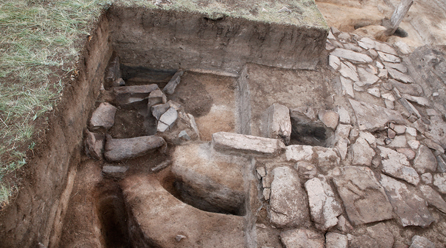
Before selecting where to excavate within the enclosure, geophysical survey was carried out. Anomalies were identified in the northern section (Areas C & D) (Eklund & Greaves Reference Eklund and Greaves2023), which also displayed a pile of stones visible on the surface. Excavations in these areas revealed the remains of several architectural features (Figure 6), including a semi-subterranean structure (approximately 5 × 4m) in the south-east section of Area C. The north-east and north-west parts of this structure contained several features made of stone and earth, and a burial was identified in the north-west part (north-east corner of MA03, see below).

Figure 6. Internal structures in MA03 and areas excavated (figure by Tal Rogovski).
Central among the identified features is an L-shaped, stone-built heating system with a two-roomed furnace (Figure 7). A lower feature, which contained an ashy layer, was probably the furnace, while an adjacent feature may have facilitated cleaning of the furnace and two flues (6.8m and 5.85m long, respectively, and 0.2–0.3m wide) that pass under the entire stone and earth platform, ending at a chimney marked by an erect standing stone. The flues are approximately 0.5–0.2m below the lower level of stones, and become progressively shallower leading up to the chimney. Most of the artefacts found in the south-east part of Area C were recovered from the vicinity of the heating system. They include a relatively large volume of animal bones, pieces of metal and organic materials and a few ceramic sherds.

Figure 7. Features in the stone and earth platform (figure by Dor Heimberg & Tal Rogovski).
The structure in Area C continues south into the north-western part of Area D, ultimately measuring 4m (north-west to south-east) × 5m (north-east to south-west). A narrow strip of predominantly sterile soil separates this structure from another, ostensibly parallel one located in the south-west of the unit. In this area two ash pits or furnaces were dug into the floor of the structure (0.5–0.6m below the floor). Both pits probably belonged to another stone heating system, similar to the one described above. The pits contained ashy soil with carbonised materials and a few large pieces of partially burnt wood, as well as animal bones and a large fragment of an iron plough. Finally, two ash pits or furnaces were uncovered in the south-eastern part of Area D. These are not associated with any larger structure.
Three Northern Song (AD 960–1127) bronze coins were uncovered during our investigations (Figure 8). Two were found directly above and below the heating system in Area C, and one was associated with an ash pit in Area D. Since these types of coins were circulated both during and after the Northern Song dynasty (Zhang & Wang Reference Zhang and Wang2011), their presence in MA03 cannot be taken as evidence of contemporaneity (see below). A number of iron objects were also uncovered in and around the enclosure (Figure 9), including a broken iron plough (found 0.45m below the surface in Area D), parts of a pot, wheel hubs, armour scales, a nail and an arrowhead.

Figure 8. Northern Song coins: 1) 嘉祐通寶 (Jiayou Tongbao: Jiayou is a reign period dated to AD 1056–1063); 2) 皇宋通寶 (Huangsong Tongbao: Huangsong, meaning imperial Song, was inscribed on coins minted between AD 1039–1053); 3) 淳化元寶 (Chunhua Yuanbao. Chunhua is a reign period dated to AD 990–994) (figure by Tal Rogovski).

Figure 9. Iron artefacts: 1 & 2) wheel hubs; 3) small fragments; 4) armour scales; 5) pot fragments; 6) plough fragment; 7) plough reconstruction (figure by Tal Rogovski).
Intrusive burial
Excavation of Area C uncovered a circular pile of stones (roughly 5m in diameter) with an undisturbed burial underneath (Grave 3). The individual, an adult male aged between 35 and 40 years, was laid in an extended supine position, with the head oriented to the north. Within the pit, a birchbark basket, green fabric, metal objects and traces of wood were uncovered. The intrusive burial was dug into the internal trench after it had already been filled in, and stones were taken from the collapsed wall of the enclosure to create a pile. Additional research is being carried out on the burial and its contents to help us better understand this unique context.
Radiocarbon dating and temporal relationships
A series of radiocarbon assays were conducted to clarify the date of the MA03 settlement and several mortuary contexts discovered both within the structure (Grave 3) and in the immediate vicinity (Graves 1, 2, 5; see online supplementary material (OSM) section A, Table S1). Nine samples were taken from the MA03 enclosure concentrating on the area around the stone-built heating system (Area C) and a large pit containing burnt earth, ash, charcoal and wood (Area D; see OSM section A, Table S2). While caution is applied to the dates associated with our unidentified wood, charcoal and bark samples, which might incur error associated with the use of ‘old wood’ (i.e. wood of unknown age prior to carbonisation), the relatively coherent grouping of our dates suggests this may not be a significant issue. Having said this, a comparison of calibrated dates from graves and the settlement shows that all grave contexts are either substantially older or younger than the use period of the settlement.
To assess the use-life of the enclosure and the time elapsed between its abandonment and the interment of Grave 3, found within the precinct of the walled settlement, we analysed the dates from Tables S1 and S2 using OxCal 4.4 Bayesian modelling software (Bronk Ramsey Reference Bronk Ramsey2021; for code and rationale see OSM sections B, C, D). Modelling of the enclosure dates as a bounded sequence distinct from the three combined dates for Grave 3 is shown in Figure 10. The chronological model for the walled settlement is informed by prior historical information as well as stratigraphic relationships between sample contexts. Given these prior sources of information, our model establishes the initial habitation of MA03 sometime between cal AD 1150 and 1216 and an abandonment date range between cal AD 1180 and 1242 (95.4% credible intervals; see OSM). When considered in terms of a 68.3% credible interval, these date ranges narrow to cal AD 1163–1210 (start) and AD 1199–1226 (end). As such, the modelled dates from MA03 are consistent with an occupation during the Jin dynasty (AD 1115/1125–1234). The later intrusive Grave 3 was constructed between 199 and 264 years after the settlement’s end date (95.4%). The adult man buried there was likely interred sometime between AD 1433 and 1452 (95.4%) (Figure 10).

Figure 10. Radiocarbon dates for the construction of MA03 and the intrusive burial (figure by William Honeychurch).
Discussion
Function of the Mongolian Arc of the south-eastern lines
The function of the MWS undoubtedly varied across time and space. Traditionally interpreted as serving a primarily military function (e.g. Jing & Miao Reference Jing and Miao2008: 30; Kovalev & Erdenbaatar Reference Kovalev and Erdenebaatar2021), research for ‘The Wall’ project now suggests that some sections of the MWS may have been more concerned with managing the movement of people, animals and goods, rather than defence against large-scale external attacks (Shelach-Lavi et al. Reference Shelach-Lavi, Wachtel, Golan, Batzorig, Amartuvshin, Ellenblum and Honeychurch2020a & Reference Shelach-Lavi, Honeychurch and Amartuvshinb; Fung et al. Reference Fung2024). New findings from our investigations of MA03 and the nearby trench line provide additional data to evaluate this interpretation.
Systematic mapping and survey along the Mongolian Arc revealed gaps in the line where neither a wall nor a trench were built (Fung et al. Reference Fung2024: 16). Our excavations near MA03 demonstrate that even where the line existed, it consisted of a shallow trench that could be easily traversed. MA03 is located on a slope at a position where those living within the structure would have been unable to see over the trench line, making them vulnerable to enemy attack (Fung et al. Reference Fung2024: 14). These findings suggest that this section of the line was not designed to effectively stop armies who might try to cross it.
The trench would have served as a potent symbol, marking the area under the direct control of the Jin dynasty. It may have also helped to channel the movement of people and their herds to gates where it was easier for them to cross. The relatively dense distribution of forts along the trench line would have allowed those stationed there to monitor who was crossing and stop them if necessary. In the event of raids, the stone walls and trenches of the enclosure could have served as strong fortifications. A small number of potentially military-related artefacts (armour scales and an arrowhead) were uncovered during the excavation of the enclosure and surrounding area, suggesting that those living there were outfitted to some degree.
Daily life on the medieval frontier
The materials and labour invested in the construction of MA03 were substantial compared to the trench line. Permanent architecture associated with settlements first emerged in Mongolia during the Xiongnu period (third century BC to second century AD) in the form of walled sites (Wright Reference Wright2021: 455–56), with large cities appearing later in the medieval period (Perlee Reference Pėrlėė1961; Rogers Reference Rogers2017; Miller Reference Miller2024). Historic documents and excavations at Jin dynasty settlements have revealed unique urban environments, characterised by rammed earth walls, administrative and religious buildings, as well as empty space for tents (Steinhardt Reference Steinhardt1999: 124). Based on the size of MA03, it could not have housed a particularly large number of people, although it is possible that there were other non-permanent structures such as ger (yurt tents) nearby, particularly in the warmer seasons. The location of MA03 on a slope would have proved advantageous against flooding in the valley caused by intermittent, heavy rainstorms, particularly in the summer. Additionally, the enclosure would have been sheltered from cold northern winds during the winter.
One of the most notable features within MA03 was the stone heating system. Heated platforms and floors made of stone or brick that functioned as both a stove and bed (referred to as khanzan khaalalt in Mongolia, ondol in Korea and kang in China) were used across north-east Asia (Davydova Reference Davydova1995: 18–19; Batbold Reference Batbold2013; Heilongjiang & Shanxi 2021). Heating systems dating to the Xiongnu through the Mongol periods have been uncovered in Mongolia (e.g. Batbold Reference Batbold2013; Bemmann & Reichert Reference Bemmann and Reichert2021: 136), and features comparable to the one excavated during our field season have been observed at structures spanning the geographical extent of the Jin dynasty (e.g. Heilongjiang Reference Honeychurch, Wright and Amartuvshin2019). The presence of this structure in MA03 indicates that it could have been occupied year-round, including during the height of winter.
Located far from the Jin heartland, it is unclear if the people living at MA03 would have required intermittent provisioning of foodstuffs or if they maintained some level of self-sufficiency. Hearths with burnt faunal remains from domesticated and wild animals (e.g. gazelle) indicate that herding was supplemented with hunting (see OSM section E), while the recovery of a broken iron plough (Figure 9, no. 6) suggests that agriculture was also practised. Soil samples taken during excavation are currently being analysed for possible plant remains. Systematic archaeological work in Mongolia has uncovered direct evidence for agriculture as early as the Xiongnu period (Honeychurch et al. Reference Honeychurch, Amartuvshin, Wright, Carolus and Hrivnyak2023) and excavations at large Mongol period settlements have produced archaeobotanical remains (Rösch et al. Reference Rösch, Fischer and Märkle2005: 492) and ploughs (Reichert et al. Reference Reichert, Erdene-Ochir, Linzen, Munkhbayar and Bemmann2022: 409) that support the cultivation of various types of crops in areas traditionally associated solely with pastoralism.
Overall, a small amount of material culture was recovered during excavations. Only a few sherds were unearthed in MA03, perhaps due to discard in middens outside of the structure or the removal of ceramic vessels during abandonment. Small or broken iron objects were recovered from MA03 and its vicinity. Evidence of iron smelting in Mongolia pre-dates the first century BC (Sasada & Amartuvshin Reference Sasada and Amartuvshin2014: 1023), and metal was clearly a valuable resource in medieval Mongolia, as evidenced by the repurposing of non-local iron fragments (e.g. Park et al. Reference Park, Honeychurch and Amartuvshin2019) and small-scale, local iron production (e.g. Amartuvshin et al. Reference Amartuvshin, Batbold, Eregzin and Batdalai2015; Park et al. Reference Park, Gardner and Burentogtokh2020; Erdenebat et al. Reference Erdenebat, Burentogtokh, Honeychurch, May and Hope2022). It is likely that the trade of iron, along with other objects, formed part of a larger network of the multidirectional exchange of goods, technology and information in this region.
Dynamic interactions on the steppe
Borderlands and frontiers were “politically, socially, ideologically and culturally charged places” (Naum Reference Naum2010: 102) that were constantly being shaped by the interplay of humans, animals, objects and politics moving through these spaces. The long history of frontier dynamics in Mongolia, beginning with the rise of the Xiongnu state, has been investigated using historical texts and archaeological investigations of objects, technologies and practices (e.g. Lattimore Reference Lattimore1940; Di Cosmo Reference Di Cosmo2002; Standen Reference Standen2006; Miller Reference Miller2024).
A wide variety of interactions were undoubtedly occurring between those living at MA03 and distant Jin officials, people stationed in nearby forts and pastoral nomads moving through the visibly modified landscape. Did MA03 and other enclosures become hubs of activity where disparate groups came together to trade goods, information and technology? Or would the interactions have been more guarded or antagonistic? Although many questions remain unanswered, the materials unearthed during our investigations are beginning to shed light on the lives of people in this liminal area, both during and after the occupation of MA03.
Monumentality and social memory
The long tradition of marking space with monumental stone and earth features (e.g. burials, mounds, stelae) dates to the Bronze Age (Wright Reference Wright2021), and extensive research has been carried out on the construction, function and impact of these monuments (e.g. Wright Reference Wright2017; Burentogtokh Reference Burentogtokh2022). Focusing on the Northern Line, Shelach-Lavi and colleagues (Reference Shelach-Lavi, Wachtel, Golan, Batzorig, Amartuvshin, Ellenblum and Honeychurch2020a: 7) have previously considered the monumentality of the MWS and how it might have been viewed by past populations. MA03, which is still visible on the landscape today, lived on in the social memory of people moving through this area even after the site was abandoned, as evidenced by the selection of this location for the post-Mongol burial. The reuse of structures for burials has also been observed in other parts of Mongolia, including a Liao fortress on the Northern Line (Amartuvshin et al. Reference Amartuvshin2024). These examples suggest that the extant remains of these constructions continued to be imbued with meaning across generations.
Conclusion
This article presents results from the 2023 field season of ‘The Wall’ project along the eastern fringes of the Eurasian steppe. Our excavations on the south-eastern line of the MWS, referred to here as the ‘Mongolian Arc’, have begun to provide insights into this enigmatic series of fortifications and earthworks. Investigation of the wall-trench line and an adjacent enclosure demonstrates that these structures were built and occupied during the Jin dynasty, clarifying the timing and sequence of construction. Architectural features, material culture and faunal remains indicate that the occupants likely lived there year-round, engaging in a range of subsistence practices, including herding, agriculture and hunting. Diversified subsistence strategies may have helped the inhabitants meet the demands of a sedentary lifestyle, which is a line of inquiry that will be investigated further through ongoing analysis of excavated materials. Finally, the discovery of the intrusive burial within the structure contributes to an understanding of the varied ways that later groups interacted with built landscapes, even long after they were abandoned.
Although post-excavation analyses are ongoing, this research—coupled with previous work by our team—contributes to the ever-growing picture of diverse lifeways on the Eurasian steppe. Questions persist about the function of the wall-trench line and the people living along its south-eastern stretches, but a compelling synthesis of the material and historical records, as we have sought to present here, provides a pathway to reveal significant insights. Taken as a whole, the initial results reported here elevate our understanding of the intricate dynamics of political frontiers occupying the very edges of ancient empires and states. Excavations at the MA03 wall and enclosure represent a window on one such frontier, on the historical cusp of sweeping sociopolitical changes that brought about the establishment of the Mongol Empire.
Acknowledgements
We extend our deepest gratitude to everyone who participated in the 2023 field season. This project would not have been possible without the kind collaboration of the Department of Anthropology and Archaeology and the Archaeological Research Center of the National University of Mongolia. We would also like to extend our thanks to Zhidong Zhang and Lance Pursey for their assistance evaluating textual information about the Jin dynasty and to Joshua Wright for bringing several important archaeological sites to our attention. Finally, we are grateful for the comments provided by two anonymous reviewers and the editor.
Funding statement
This research is supported by the European Research Council under the European Union’s Horizon 2020 research and innovation programme (‘The Wall’ project, grant agreement no. 882894).
Online supplementary material (OSM)
To view supplementary material for this article, please visit https://doi.org/10.15184/aqy.2025.49 and select the supplementary materials tab.


 Open access