Political scientists have long debated the strategies that politicians pursue as they allocate the resources they control. Is their objective to reward their political supporters or their coethnics (Bates Reference Bates, Rothchild and Olorunsola1983; Cox and McCubbins Reference Cox and McCubbins1986; Posner Reference Posner2005)? Is it to induce people who did not support them in the past (or who did not vote at all in the last election) to support them in the future (Lindbeck and Weibull Reference Lindbeck and Weibull1987; Nichter Reference Nichter2008)? Or is their goal simply to help the largest number of people or those with the greatest needs? Adjudicating among these different strategies is challenging, both because of the difficulty in identifying precisely who is targeted by the transfers and because individual politicians rarely have full discretion over resource distribution. In this article, we leverage data from a policy innovation in Kenya, the Constituencies Development Fund (CDF), which permits us to circumvent these challenges and provides a clean and unambiguous test of the first of these hypotheses: that politicians reward their supporters.
Since its inception in 2003, Kenya’s CDF program has provided Members of Parliament (MPs) with millions of dollars of funding to build development projects in their constituencies. We study how MPs allocated these funds during the program’s first five years—a period when MPs had nearly complete discretion over where to locate the projects they funded with CDF resources. Footnote 1 We exploit a unique dataset on the precise geo-locations of all CDF projects initiated between the start of the program and 2007, when the then-incumbent MPs ran for re-election. To explain the allocation patterns we observe, we combine these data with voting returns from more than 14,000 polling stations in the 2002 parliamentary elections as well as highly disaggregated data on population density, the location of roads, poverty rates, and ethnic demographics. We then use spatial modeling techniques to examine the placement of projects within each constituency as a function of these independent variables, generating estimates of the relationship between project location and levels of political support (as well as each of these other factors) in 196 different constituencies. Footnote 2 Taken together, these data and methods put us in a unique position to learn how MPs allocate the resources at their disposal and how the strategies they pursue vary with the local conditions they face.
We find evidence that Kenyan MPs do not, in fact, favor their supporters in the distribution of CDF projects as strongly or as universally as the literature would lead us to expect. This is because, as we find, MPs also consider other factors when they decide where to place CDF projects: the number of people living in the area in question, the area’s distance from a paved road, the local poverty rate, the proportion of coethnics in the area, and the location’s proximity to their own village. We show that once we control for these other determinants of project placement, the effect of political support diminishes. Equally important, we find that the tendency for MPs to channel CDF projects to their supporters varies from constituency to constituency depending on the MP’s affiliation with the ruling political coalition, his margin of victory in the last election, and, in particular, whether the MP’s supporters and non-supporters are spatially segregated from one another. Footnote 3 These findings challenge the conventional wisdom that African politicians are motivated primarily by a clientelistic bargain in which political support is exchanged for public resources (Chabal and Daloz Reference Chabal and Daloz1999; Lindberg Reference Lindberg2010) and underscore how such bargains—to the extent that they do shape politicians’ behavior—vary across actors and settings.
Beyond these empirical findings, this paper makes three broad contributions to the literature on distributive politics. First, by studying the allocation decisions of constituency-level rather than national-level actors, we can exploit cross-unit variation in the associations we find between project placement and political support. This allows us to go beyond the question of whether politicians favor their supporters to identify the conditions that make such behavior more or less likely. This represents an advance over prior work in which allocation decisions are made by a single decision maker—the president, the ruling party, “the government”—subject to a fixed set of conditions. Our analysis, by contrast, explores the allocation decisions of 196 separate constituency-level actors, each operating under the same set of rules and with similar resources, but in different social, demographic, and political environments. Footnote 4 Our constituency-level approach also has the benefit of aligning theory—which focuses on within-district, rather than cross-district, allocations (Cox Reference Cox, Shapiro, Stokes, Wood and Kirshner2009; Cox and McCubbins Reference Cox and McCubbins1986; Dixit and Londregan Reference Dixit and Londregan1996)—with empirical tests.
Second, the geo-coded project data we employ, combined with the point process approach we use to model project location decisions, represents an advance over the common practice of aggregating outcomes and explanatory variables to larger administrative units or imposing an arbitrarily sized grid over the area studied and coding the outcome of interest as present or absent in each grid square. Footnote 5 Such approaches implicitly assume that all the inhabitants of the unit have equal access to the resources that the unit receives, obscuring the more localized relationship between project placement and characteristics that may vary, sometimes quite considerably, within the units studied. While the severity of the resulting aggregation bias will depend on both the distribution of the relevant explanatory variables and the sizes of the units to which the explanatory and outcome variables are aggregated—with analyses done at lower levels of aggregation presenting less of a problem than analyses done at a higher level like the constituency or district—it will always be preferable to avoid the problem altogether by estimating the association between support and project placement, as we do here, in continuous space rather than within discrete units (Amrhein Reference Amrhein1995). An additional problem with aggregating to the administrative unit is that in Kenya, as in many other places, the borders of such units are products of political processes (Kasara Reference Kasara2006; Oucho Reference Oucho2002), so using those borders to delineate units of analysis may introduce endogeneity. Studying project placement directly, without relying on ad hoc aggregations, allows us to avoid this potential pitfall.
Finally, our work joins a growing body of research emphasizing the role of geography in politics (Enos Reference Enos2017; Jusko Reference Jusko2017). However, whereas most of this literature focuses on how the distribution of political support affects public policy outcomes (Beramendi Reference Beramendi2012; Jurado and Leon Reference Jurado and Leon2017; Rickard Reference Rickard2012) or how votes translate into seats in different types of electoral systems (Calvo and Rodden Reference Calvo and Rodden2015; Chen and Rodden Reference Chen and Rodden2013; Jusko Reference Jusko2015), our study focuses on the impact of political geography on the distribution of more local public goods. Specifically, we study how the spatial concentration of the people living in a voting district and the segregation of the incumbent’s supporters and opponents shape a politician’s allocation strategies. In this regard, our analysis is most similar to Ejdemyr et al. (Reference Ejdemyr, Kramon and Robinson2018), who show that MPs in Malawi are more likely to target their coethnics with new boreholes when their coethnics are spatially segregated from members of other communities. Footnote 6 Our study differs from theirs by examining both a wider range of projects and a broader set of constituency-level factors that might account for cross-constituency variation in allocation patterns. In addition, whereas Ejdemyr et al. (Reference Ejdemyr, Kramon and Robinson2018) investigate the impact of segregation on an aggregate outcome (the number of boreholes allocated to a given constituency), we are able to investigate the impact of segregation on the within-constituency targeting of CDF projects. Notwithstanding these differences, both studies demonstrate the importance of partisan/ethnic segregation and, by doing so, add a critical explanatory factor to their accounts of politicians’ strategic behavior. Indeed, the findings of both studies suggest that analyses that fail to incorporate these spatial characteristics may generate misleading conclusions about how distributive politics operates.
THE CONSTITUENCIES DEVELOPMENT FUND (CDF) PROGRAM IN KENYA
Created under the Constituencies Development Fund Act of 2003 (Government of Kenya 2003), the Kenya Constituencies Development Fund is provided an annual allocation of not less than 2.5% of all ordinary government revenues. These funds are distributed among the country’s 210 electoral constituencies according to a formula by which 75% of the monies are divided equally and the remaining 25% are allocated based on each constituency’s poverty rate. Once the funds arrive in each constituency, they are disbursed by a constituency-level CDF Committee, which, during the period we study, was effectively controlled by the MP. Citizens and organized groups are invited to apply for projects, but the committee (in practice, the MP during the period we study) determines which projects are funded and where they are located. The MP’s ability to control the CDF Committee stems both from his statutory role as its chairman and from his ability to select the committee’s members (Mapesa and Kibua Reference Mapesa and Kibua2006)—as well as from a weak oversight of the CDF program by both citizens and the national government. As a consequence, CDF funds were widely regarded during the period we study as pesa ya Mheshimiwa, Swahili for “the MP’s money.” Footnote 7
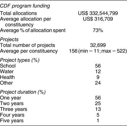
CDF transfers represent a considerable infusion of funds for local development. Total CDF allocations between 2003 and 2007 was nearly $333 million (see Table 1). This amounts to an average of $316,709 per constituency per year and represents roughly 18% of the total average development expenditure per constituency on education, roads and public works, health, and water. Footnote 8 Countrywide, CDF allocations funded a total of 32,699 projects over the five-year period we study, or an average of about 156 projects per constituency. As indicated in Table 1, an average of 73% of the funds allocated were actually spent on projects. Although this implies that some MPs “passed on pork” (Keefer and Khemani Reference Keefer and Khemani2009), this figure compares favorably with both the Kenyan central government, which utilized only 45% of its development budget in 2004–05 (Ndii Reference Ndii2014), and with decentralized fiscal transfer schemes in other settings. Footnote 9
TABLE 1. Basic Statistics on CDF Projects in Kenya, 2003–07
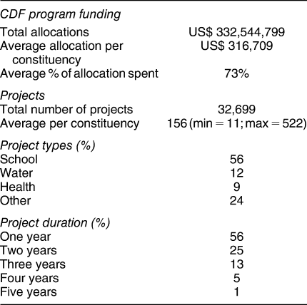
The CDF Act stipulates the CDF funds can be used for any project whose “prospective benefits are available to a widespread cross-section of the inhabitants of a particular area” (Government of Kenya 2003). This requirement means that they are spent on local public goods: the rehabilitation of school classrooms, bridge repairs, road grading, water projects, or the construction of local infrastructure such as dip tanks or public toilets. Footnote 10 The CDF Act permits a small amount of the funds to be spent on administration and education bursaries, but this is limited to less than 10% of total expenditure (and in practice is much less). Footnote 11 As Table 1 shows, more than half of the projects initiated between 2003 and 2007 were education related, with the next largest categories being water and health. CDF projects are generally completed within one year, although they occasionally stretch over two years or longer.
The CDF program thus presented each MP with a large, annually replenished, exogenously determined Footnote 12 sum of money that, subject to minimal restrictions, could be allocated within the constituency with nearly total discretion. Footnote 13 Although CDF funds constitute just one part of the local development expenditure made in each constituency, the close identification of CDF with the MP makes it an extremely valuable political resource. The CDF program thus provides researchers with a nearly ideal opportunity to observe how political actors distribute the resources they control. And since we can observe these distribution decisions in 196 separate “laboratories,” we can also draw important lessons about the conditions under which they pursue different allocation strategies.
WHAT FACTORS AFFECT WHERE CDF PROJECTS ARE PLACED?
As a local public good, the benefit of a CDF project is inversely correlated with a person’s distance from it. This means that we can infer which people an MP is targeting based on where in his constituency he chooses to locate each CDF project. Footnote 14 Although the geographic scope of the benefit from a given project may vary with its type—for example, a bridge may benefit people from a wider radius than a borehole—all projects should provide utility to people in inverse proportion to their distance from it (and projects like bridges constitute only a small share of our sample).
Our data allow us to adjudicate between two broad families of hypotheses for how MPs allocate the CDF resources they control. The first emphasizes MPs’ desire to reward their political supporters and/or favor their ethnic kin. The notion that this is what voters expect, and thus what MPs try to maximize, is a central tenet in both theoretical and empirical work on African politics (Barkan et al. Reference Barkan, Mattes, Mozaffar and Smiddy2010; Bates Reference Bates, Rothchild and Olorunsola1983; Chabal and Daloz Reference Chabal and Daloz1999; Lindberg Reference Lindberg2010; Posner Reference Posner2005; Wantchekon Reference Wantchekon2003). We test for the reward-your-supporters variant of this hypothesis by estimating the spatial association between project placement and the level of support for the MP in the previous election. We test for the favor-your-ethnic-kin variant by estimating the spatial relationship between project placement and the number of the MP’s coethnics living in the area. Footnote 15 Given the close association in Kenya between ethnicity and voting behavior (Barkan and Ng’ethe Reference Barkan and Ng’ethe1998; Gibson and Long Reference Gibson and Long2009), one might think that an MP’s ethnic relationship with voters would already be built into the distribution of his political support. However, Kenyan constituencies are often ethnically homogeneous (43% have a level of ethnic diversity less than 0.3, according to calculations based on data described by Harris Reference Harris2015), so partisanship and ethnicity frequently do not track together at the constituency level—at least not at the level we measure ethnicity in this study, which is based on census categories. This makes it meaningful to address these sub-hypotheses separately. Footnote 16
We also take a second cut at the favor-your-kin hypothesis by estimating the relationship between project placement and the distance from the MP’s home village. Especially in ethnically homogeneous constituencies, the relevant communal distinction may not be between coethnics and non-coethnics (since there are none, or very few, of the latter) but between members of the MP’s family or clan and other members of the broader community. The distance-to-the-MP’s-village measure is meant to capture these potentially relevant intra-ethnic kinship distinctions.
The second broad hypothesis we test is that MPs use their CDF funds to help the greatest number of people and/or those with the greatest needs. To test for the help-the-greatest-number variant of the mechanism, we estimate the spatial association between project placement and local population density. To test for the help-those-with-the-greatest-needs variant, we estimate the spatial association between project placement and the estimated number of people living in poverty in the area. Since both of these mechanisms require that money be spent efficiently, and since projects located closer to paved roads are cheaper to build, we also test this hypothesis by estimating the association between project placement and the distance to a paved road. Footnote 17
DATA
CDF Project Locations
MPs are required to submit annual reports to the national CDF Board detailing how they have used their CDF allocations. These reports, which are posted in pdf form on the CDF Board’s public website, provide project names (e.g., Gatina Bridge Repair; Kipruti Water Project), a description of the activity done (e.g., roofing, plastering, painting one classroom; construction of cattle dip; building of foot bridge) and information about the amount of money allocated to the project for the year in question. We code the sector in which the project is located based on its name. Our principal data, a geo-referenced set of 32,699 CDF projects in 196 constituencies for the 2003 to 2007 financial years, are extracted from this source. Footnote 18
Since project data from the website did not include any explicit geographic coordinates, we geo-referenced the project records by matching project names to the names of facilities for which point or polygon data were available (e.g., schools, market towns, health centers, water/irrigation features). Footnote 19 We were able to match 60% of projects to an exact geo-referenced point. In cases in which we were not able to match a project to a specific point, we randomly placed the project at a point within the smallest unit to which we could assign it (i.e., the convex hull of candidate points likely to fall near the project, or the project's enumeration area, sub-location, location, or constituency) with the probability of placing the project at each point in the unit proportional to the estimated population density at that point. This procedure prevented us from inadvertently locating projects in national forests, parks, reserves, bodies of water, or other unpopulated areas.
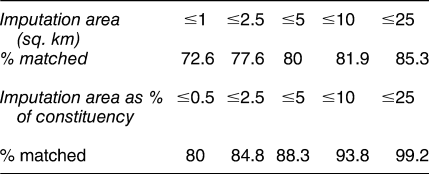
Where we were not able to match a project to a specific point, our procedures allowed us to come quite close. As indicated in the second row of Table 2, we were able to match 72.6% of projects to a specific point or to an area of 1 square kilometer or less, and 77.6% to within 2.5 kilometers—well inside the radius within which residents would benefit from most projects. As shown in the second row of the Table, 80% of projects were placed within an area smaller than 0.5% of the constituency and 88.3% within an area smaller than 5% of the constituency.
TABLE 2. Matching of CDF Projects
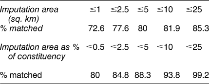
CDF projects were matched to existing points and named polygons, in order to approximate project location. projects without a specific point match were imputed within the smallest possible polygon.
To account for measurement error in our imputation of project locations, we created 21 separate data sets of imputed project locations and ran all of the analyses in which project locations are the dependent variable on each of these 21 separate data sets. The results we report below are the average coefficient estimates of these 21 separate regressions, with standard errors calculated following the procedures discussed by King et al. (Reference King, Honaker, Joseph and Scheve2001). Further details of our imputation procedures, along with robustness tests of our main results without imputation, are provided in Online Appendix C.
Explanatory Variables
We measure political support for the MP using polling station-level electoral returns from Kenya’s 2002 parliamentary elections. These elections took place a year before the launch of the CDF program and can thus be taken as exogenous to any effects that the program might have subsequently had on election outcomes. We link these results to a geo-referenced polling station dataset to create rasters that identify the estimated number of votes won by the winning candidate at each point in each constituency. We do this by assigning each 100 square meter grid cell in each constituency to its most proximate polling station using a Voronoi diagram. Then we interpolate the level of political support in each grid square by multiplying the share of votes won by the incumbent at the polling station by the grid square’s estimated population, based on the high-resolution population density rasters described by Linard et al. (Reference Linard, Gilbert, Snow, Noor and Tatem2012). Footnote 20 With approximately 14,000 polling stations countrywide and an average of roughly 67 polling stations per constituency, this procedure generates an extremely fine-grained and accurate constituency-level map of the distribution of electoral support for the incumbent MP. Footnote 21
To generate our measure of voters’ ethnic match with the MP, we employ polling station-level estimates of ethnic demographics from Harris (Reference Harris2015) to create rasters for each constituency identifying the spatial distribution of coethnics using a method identical to that described for political support. We also create rasters indicating the square of the distance from each point in each constituency to the MP’s home village. Footnote 22
We measure population density using the data from Linard et al. (Reference Linard, Gilbert, Snow, Noor and Tatem2012). Using data described by Tatem et al. (Reference Tatem, Gething, Pezzulo, Weiss and Bhatt2015), we create constituency-level rasters containing estimates of the number of people living in poverty in each one square kilometer grid cell. We utilize the World Bank/Kenya Ministry of Roads and Public Works dataset described by Government of Kenya (2006) to create a raster identifying the square of the distance from each point in each constituency to a paved road. Online Appendix B provides further details on the sources and construction of these measures.
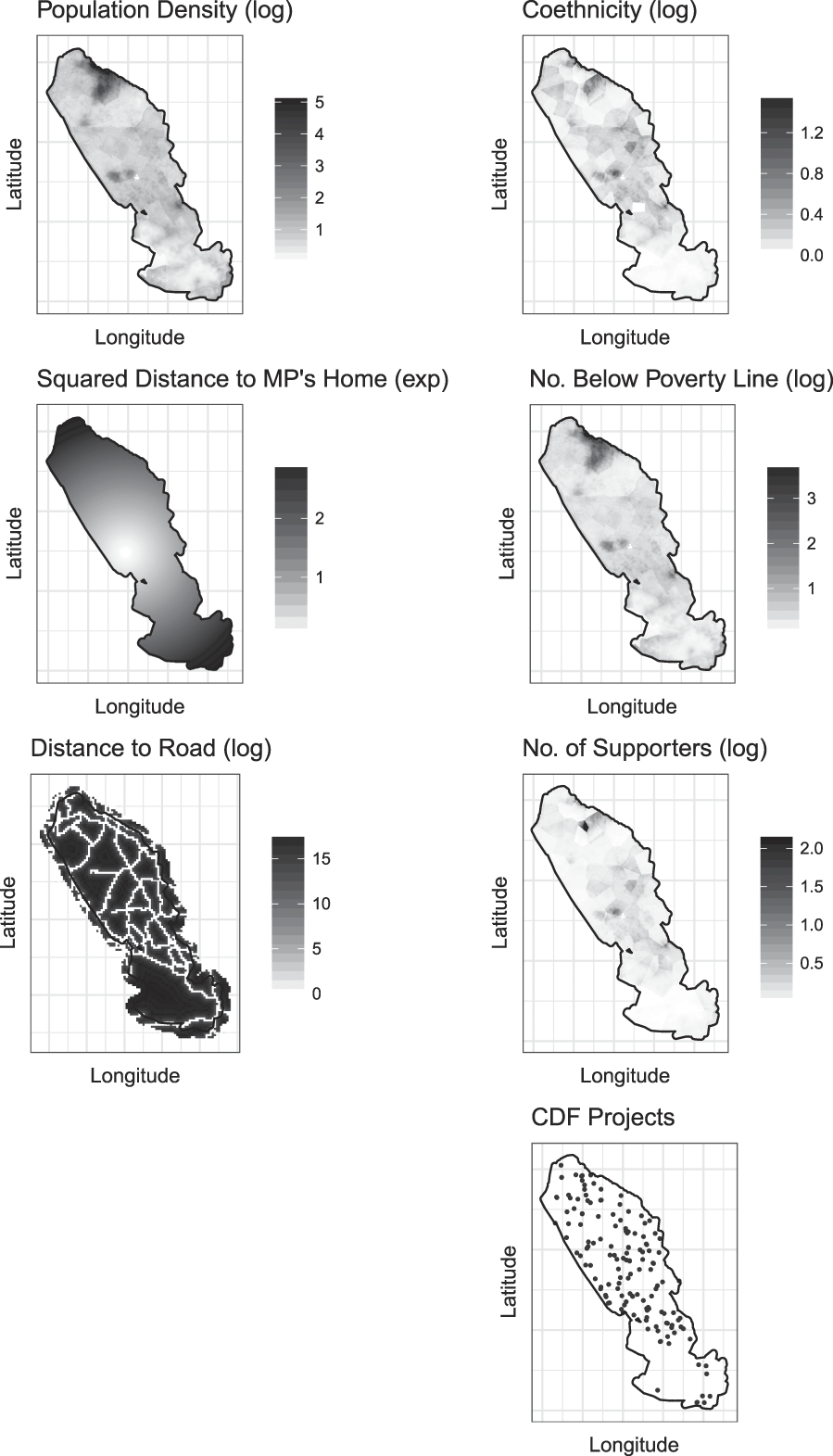
Figure 1 provides an illustration of what our data look like for an example case: the Rift Valley constituency of Eldoret South. As the figure makes clear, our estimation of the spatial association between project placement and the other covariates is based on extremely rich data.
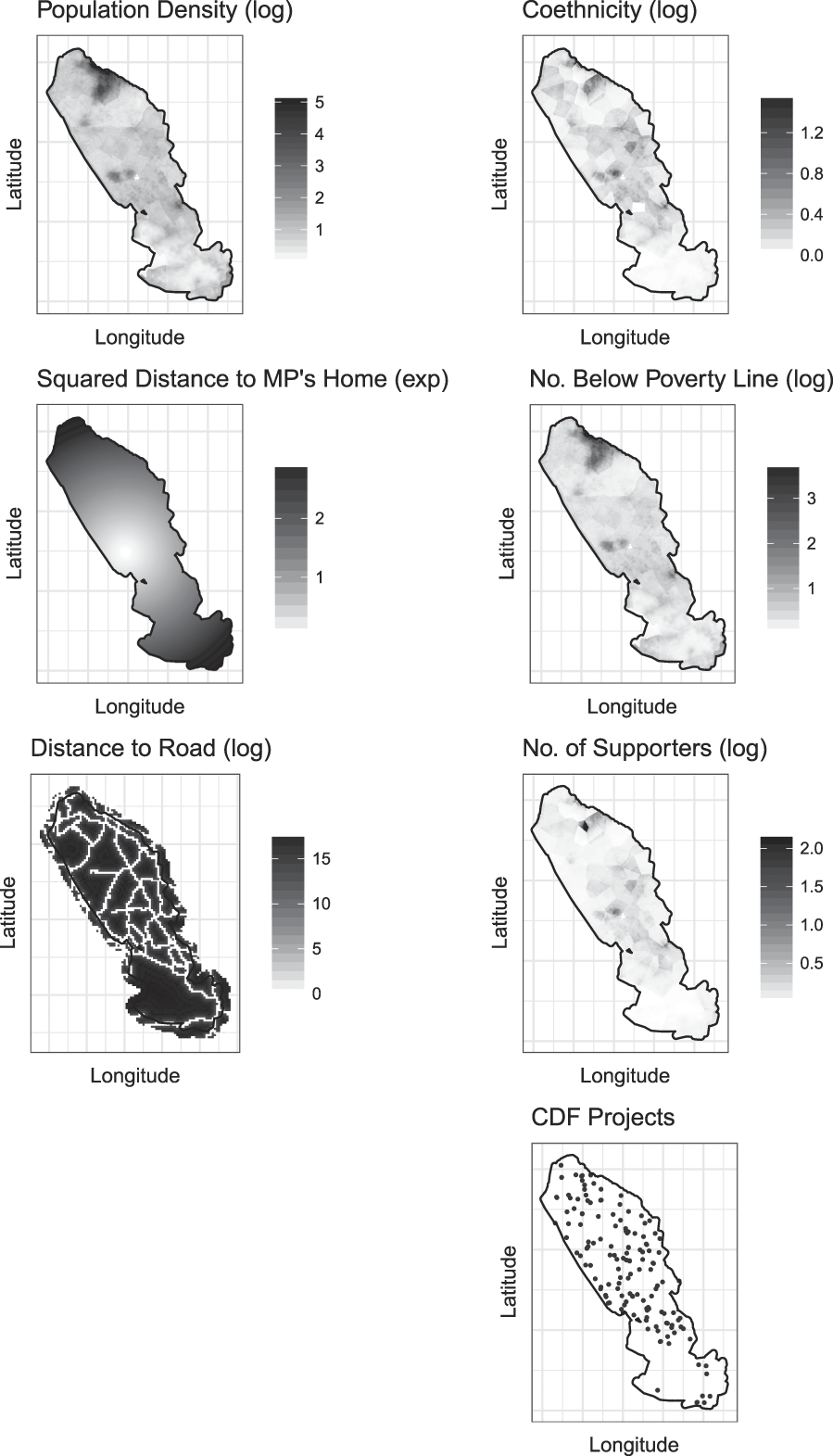
FIGURE 1. An Illustration of Our Data in Eldoret South Constituency
Note: The independent variables in the point process model are represented by raster data (top six panels), whereas the project locations are represented as points (bottom panel).
MODELING THE ASSOCIATION BETWEEN PROJECT LOCATIONS, POLITICAL SUPPORT, AND OTHER COVARIATES
To estimate the spatial relationship between where CDF projects are located and our explanatory variables of interest, we treat the distribution of CDF projects as a Poisson point process that varies across space as a function of the social, spatial, and political attributes described above (Diggle Reference Diggle2013; Gatrell et al. Reference Gatrell, Bailey, Diggle and Rowlingson1996). Poisson point process models are commonly used in fields such as epidemiology, geology, meteorology and ecology where researchers have identified occurrences of a phenomenon of interest (for example, outbreaks of a disease or locations of particular mineral deposits, weather patterns, or plant species) and seek to understand the spatial distribution of these phenomena in terms of a set of explanatory variables. However, we know of only two applications of the technique to political science problems: a study of radio and cell phone penetration and collective violence in Africa (Warren Reference Warren2015) and a study of the spatial location of air-polluting firms in the United States (Monogan, Konisky, and Woods Reference Monogan, Konisky and Woods2017).
The intuition behind how the point process model works is straightforward. Begin by projecting an interpolated gradient of some variable of interest (in our case, the number of votes won by the MP in the last election) onto a two-dimensional geographic space. Then locate the outcome data (in our case, the locations of CDF projects) in that space and complement these points with an arbitrary number of “dummy” points (representing, in our case, locations where projects are not located). Then divide the space into polygons that contain outcome information about both the dummy and outcome locations, as well as spatial independent variables of the sort described in the previous section. This “pseudolikelihood” approach allows us to estimate the relationship between the variable of interest and the number of observed points (projects), either conditional on the other covariates or without them. For additional information on point process models, see Baddeley and Turner (Reference Baddeley and Turner2005) and Renner et al. (Reference Renner, Elith, Baddeley, Fithian, Hastie, Phillips, Popovic and Warton2015). For further technical details, see Online Appendix A.
Advantages of a Point-Level Approach
The point process approach has two distinct advantages over standard techniques for studying project-level political allocation decisions. First, the approach can account for multiple projects in the neighborhood of a given point, each at different distances from it and with different interpolated levels of our covariates of interest at each point. Second, it allows us to model spatial variation in project placement directly without relying on aggregations such as districts, constituencies, villages, or other administrative units. Aggregating outcomes and explanatory variables to the administrative unit is a reasonable strategy when the outcome of interest is plausibly related the average level of some factor across an area—for example, when the impact of a radio-delivered public service campaign is hypothesized to be related to the share of households receiving a radio signal or when the share of votes for a particular political party is hypothesized to vary with the percentage of people belonging to a specific ethnic group. But the approach can be problematic when the outcome of interest affects some people in the unit more than others, as is the case with the placement of a CDF project. For example, there are more than 70,000 schools in Kenya but only about 2,100 wards. If MPs can allocate CDF projects (say, a new classroom or a girls' toilet) to only some schools, then a ward-level analysis will miss most of the within-ward variation in how these funds are allocated. For applications of this sort, operating at a finer level of geographic resolution is critical for generating meaningful estimates of the factors that are associated with the occurrence of the outcome that is being studied.
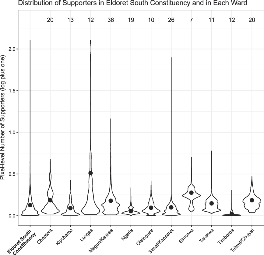
To illustrate the potential pitfalls of aggregating to the sub-constituency unit level in our setting, consider Figure 2, which shows violin plots of (log plus one of) the pixel-level distribution of supporters in Eldoret South Constituency and in each of the constituency’s 11 wards. The distribution of supporters varies widely across the constituency, and both across and within most wards. In Timboroa ward (second from the right), very few people voted for the incumbent MP (the mean level of support, given by the black dot, is near zero) and the MP’s level of support varies little across different parts of the ward (nearly all the mass of the distribution is very close to the mean). In such a context, aggregating to the level of the ward would not result in a large loss of information. However, in Langas ward (fourth from the left), as in the constituency as a whole (leftmost plot), the level of support for the incumbent varies considerably across space. In some parts of the ward, very few people supported the MP in 2002. But in other parts of the ward, they supported him strongly. In this case, aggregating to the ward level (which would involve taking the mean level of support for the incumbent, depicted by the black dot, and assigning it to every pixel in the ward) would be quite misleading. It would imply that an MP seeking to locate projects close to his supporters would be equally likely to locate projects at every point in the ward when, in fact, he would be much more likely to place projects in some places than others. In settings like Langas (and most of the wards in Eldoret South look more like Langas than like Timboroa), aggregation to the ward level obfuscates precisely the allocation problem that we are interested in examining: how MPs target projects at the local level.
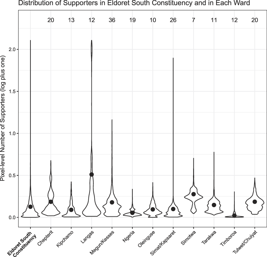
FIGURE 2. Distribution of Supporters within Each Ward, Eldoret South Constituency
Note: Ward means are indicated by the black dot. The number of CDF projects in each ward is listed at the top of the figure.
If MPs were only able to target projects to broad sections of their constituency (as they might if they were locating a major hospital that served a wide area), then analyzing patterns of favoritism at the ward level might make sense. But the CDF projects we study are much smaller in scale, and MPs are able to locate them at or very near the human communities they are targeting. Analyzing project locations at the point level is therefore appropriate for the process of project-level allocation we are studying.
Furthermore, to the extent that MPs make their decisions about where to place CDF projects in response to the locations of their supporters, this information unfolds in the continuous space of their geographic constituency, not across aggregated units that, while perhaps relevant for political actors running for offices below the level of the constituency (such as ward councilors), are irrelevant for the MP’s own electoral fortunes. Within a constituency, there are no electoral rules requiring that a candidate for a parliamentary seat must win a certain number of wards or that his votes must be distributed around the constituency in a certain way. The only requirement is that the candidate must win the most votes within the constituency as a whole. It therefore makes no sense to aggregate project locations and levels of electoral support to such units if data can be constructed at the point level. Footnote 23
Population Density
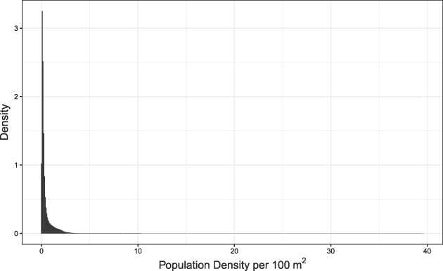
A complexity that arises from the move to a point-level analysis is that CDF projects are very unlikely to be placed where there are no people. This presents a problem because, as Figure 3 demonstrates, the vast majority of Kenya’s land area is uninhabited (or very nearly so). This highly skewed distribution of people generates a strong mechanical correlation between population density and our other explanatory variables when they are measured at the pixel level. Footnote 24 This means that any estimate of the association between supporters and project placement will be driven largely by population density. The same is true for the number of people living in poverty, the number of people belonging to the MP’s ethnic group, and the distances from roads and the MP’s home village.

FIGURE 3. The Highly Skewed Distribution of Population in Kenya
Note: Pixel-level data.
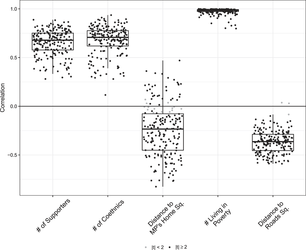
These strong correlations are clearly demonstrated in Figure 4, which plots the grid square-level correlation in each constituency between the log of population density and each of our main explanatory variables, with correlations where |t| ≥ 2 plotted as black points. Footnote 25 As is standard, the interquartile range of the distribution and the median are indicated by the box and the dark horizontal bar that bisects it, respectively. The strong positive correlations between population density and the number of supporters, number of coethnics, and number of people living in poverty stem from the fact that one cannot have supporters, coethnics or people living in poverty where there are no people (and, in the case of the number of people living in poverty, from the fact that the majority of people in Kenya are poor). The correlation with distance to roads has a slightly different source: the endogenous location of roads where people live and the tendency of people to locate themselves close to transport. Given these strong relationships, it becomes difficult to separate out the effect of each variable from the effect of population density.
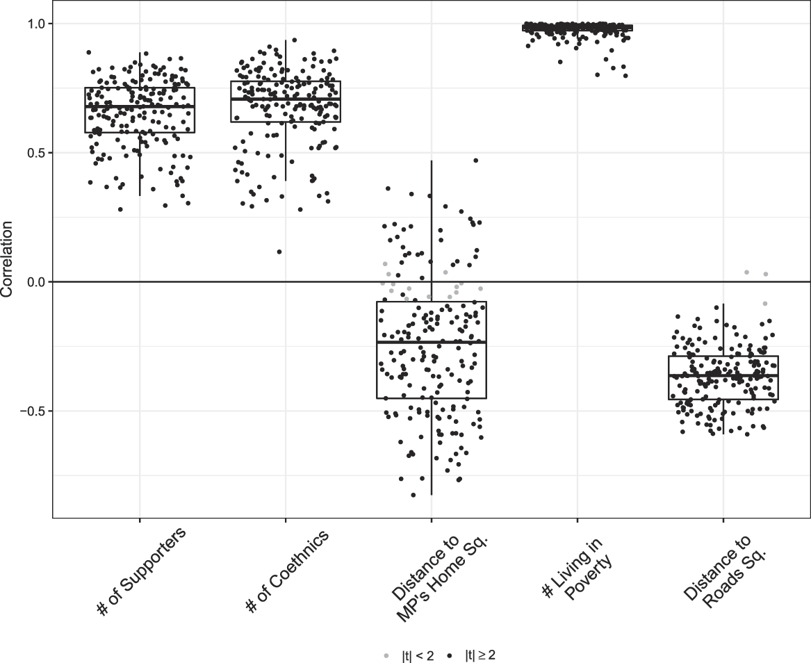
FIGURE 4. The Correlation Between Log Population Density and Other Variables
Note: Each dot represents a constituency-level correlation calculated using a simple pearson’s correlation coefficient in a random sample of locations across each constituency. Correlations that are statistically different from zero (with a t-statistic greater than two) are plotted in black; those not significantly different from zero are plotted in gray.
To deal with this problem, we regress (the log of) population density on each of our explanatory variables and use the residuals from these regressions in lieu of our direct measures of each variable. This allows us to interpret the estimated spatial association between each explanatory variable and project placement as capturing the effect of the part of each variable that is not due to population density.
CONSTITUENCY-LEVEL RESULTS
The fact that our data enable us to estimate the association between each of our explanatory variables and project placement in 196 separate constituencies presents a challenge for how to present our findings. One approach would be to estimate a pooled model across all 196 units and report the results of that single analysis. However, a pooled regression assumes that the process under investigation (project placement) happens the same way in all units and can thus be estimated appropriately in a single model. This is at odds with both the evidence we present below and our priors, which are that MPs face different local conditions and will thus pursue different strategies of project allocation in different constituencies. Footnote 26
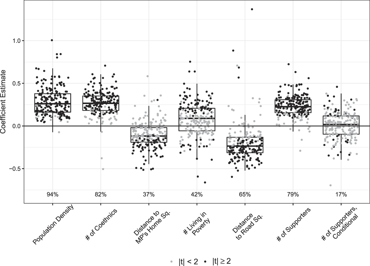
We therefore eschew a pooled analysis and instead present the distribution of constituency-level estimates for each variable of interest (with estimates standardized for cross-constituency comparability by subtracting the mean and dividing by the standard deviation). Each boxplot in Figure 5 presents the estimated association between project placement and the variable in question for each of the 196 constituencies in our analysis. Constituencies in which the estimated relationship has a |t| ≥ 2 are plotted as black points (the share of constituencies that surpass this threshold are reported below each boxplot). As noted, the constituency-level estimates are the average of 21 separate regressions, each using a slightly different set of imputed project locations, thus explicitly taking into account spatial measurement uncertainty.
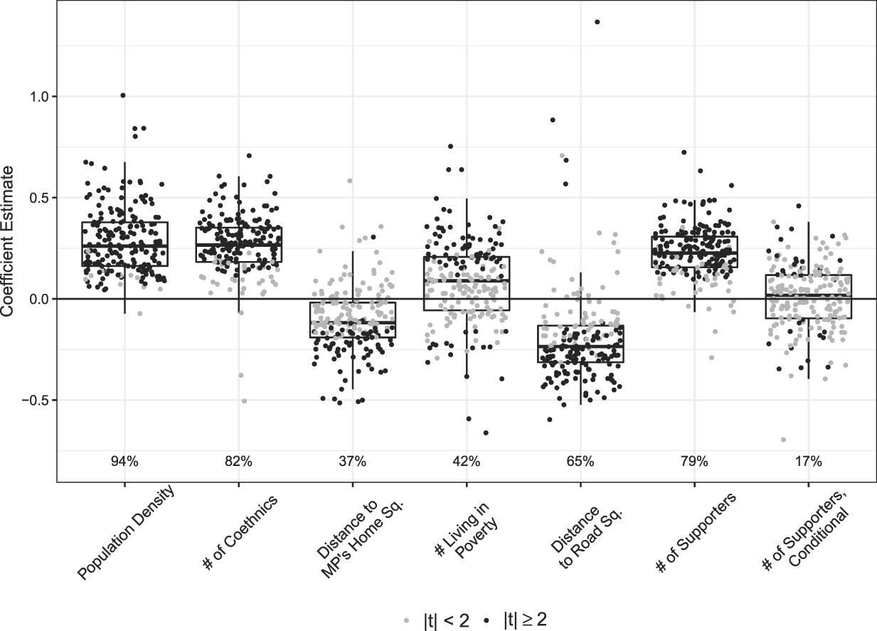
FIGURE 5. What Factors Affect Where CDF Projects Are Placed?
Note: Each dot represents a constituency-level coefficient estimate, with coefficients that are statistically different from zero (with a t-statistic greater than two) plotted in black and those not significantly different from zero plotted in gray. The left-most boxplot shows the bivariate relationship between population density and project placement. The next five present the relationships between the residualized version of the listed covariates and project placement. The right-most boxplot shows the relationship between the residualized number of supports and project placement, conditional on the covariates in columns 1–5. The percentages at the bottom of the figure report the percentage of constituency-level coefficients that are significant in each boxplot.
The first column in Figure 5 presents the bivariate constituency-level relationships between project locations and population density; the second through sixth columns present the bivariate relationships between the (residualized versions of the) listed variables; and the final column presents the estimates from the full regression where the plotted quantity is the relationship between the (residualized) number of supporters and project locations, conditional on the variables in the first five columns.
As expected, there is a statistically significant positive association in nearly all constituencies between population density and project placement (column 1). In the median constituency, a one standard deviation increase in the log of population density is associated with an additional 0.25 projects allocated to that area. This is consistent with the interpretation that MPs are more likely to allocate CDF projects to areas containing large numbers of people. However, as noted, the result is also in large part mechanical: very few projects get placed in areas that are unpopulated. Moreover, given the strong correlations between population density and the other explanatory variables shown in Figure 4, it is impossible to rule out that these results are picking up the effects of the other causal factors—a concern that justifies our strategy of using the residuals in lieu of the direct measures of the variables we turn to next.
In keeping with the received wisdom about the central role of ethnicity in Kenyan politics, the vast majority of MPs locate CDF projects in areas dominated by their coethnics (column 2). Our estimates suggest that, in the median constituency, a one standard deviation increase in the number of coethnics in an area translates to an increase of 0.27 projects (in log units). This finding is all the more striking given that many Kenyan electoral constituencies are ethnically homogeneous, which makes targeting projects along ethnic lines quite difficult. We also find evidence (in column 3) that MPs in many (but, somewhat surprisingly, not all) constituencies are more likely to locate CDF projects in proximity to (i.e., at smaller distance from) their home village.
The relationship between poverty and project placement is more mixed (column 4). Although there are some constituencies in which the association is positive (and a handful in which the relationship is statistically significant and negative), in most constituencies CDF projects are no more likely to be placed in areas with larger numbers of poor people. Contrary to the CDF program’s stated objectives, CDF funds do not appear to have been used as a tool for poverty alleviation. Footnote 27
Another interpretation of these results, however, is that poverty cuts two ways. On the one hand, it makes people more deserving of development resources. But on the other hand, it makes people less able to mobilize to demand that projects be located in their areas (recall that while CDF allocation decisions are made by the MP, community members may also, and frequently do, apply for projects). Consistent with this second interpretation, Baird, McIntosh, and Özler (Reference Baird, McIntosh and Özler2013) provide evidence from Tanzania that poverty is negatively associated with the likelihood of applying for project funding in a program similar to CDF. The lack of a statistically significant association between poverty and project placement in many constituencies may simply reflect the offsetting effects of these two processes.
The association between project placement and distance to paved roads also has the expected negative sign in most constituencies, suggesting that MPs tend to put projects closer to (that is, at a smaller distance from) paved roads. Our estimates suggest that, for the median constituency, a one standard deviation increase in the square of the distance from a road leads to a decrease of approximately 0.24 projects. This aligns with the intuition that accessible projects are more valuable to both MPs and constituents.
We turn now to the association between project placement and the number of votes won by the MP in the last election (column 6). The bivariate relationship is significant and positive in the vast majority of constituencies, suggesting that MPs are indeed more likely to put CDF projects in areas where their supporters are located. In the median constituency, a one standard deviation increase in the number of supporters translates into an increase in the number of projects in an area of average support by 0.25.
However, this relationship weakens significantly when we control for the other factors that we have just shown to be also associated with project placement. Once we have accounted for the effect of the number of the MP’s coethnics, the square of the distance to the MP’s home village, the number of people living in poverty, and the square of the distance to paved roads (and, indirectly via residualization, population density), there is no relationship in the median constituency between the level of political support the MP received in the last election in a given area and the likelihood that he places a CDF project in that area. Footnote 28 As noted, this finding runs against the conventional wisdom that politicians in Africa use the resources they control first and foremost to favor their own.
However, this null effect in the median constituency masks significant cross-constituency variation. In places like Yatta in Machakos district, Kacheliba in West Pokot district, Kieni in Nyeri district, and Butula in Busia district (to select but a few of the constituencies with large positive coefficient estimates), our results suggest that MPs strongly steered projects to their supporters. But in places like Kathiani in Machakos district, Wundanyi in Taita Taveta district, and Mbita in Suba district (to select but a few of the constituencies with zero coefficient estimates), we find no evidence that MPs were any more likely to channel CDF projects to areas in which more people voted for them in the last election. In still other constituencies (for example, Malindi in Malindi district or Ndia in Kirinyaga district), we estimate a statistically significant negative relationship between political support and project placement, suggesting that MPs were more likely to put CDF projects in places where their political support was weaker. These findings suggest that the interesting question may not be whether politicians reward their supporters but under what conditions.
UNDER WHAT CONDITIONS DO MPS FAVOR THEIR SUPPORTERS?
The factors that might lead MPs to be more or less likely to target their supporters with CDF projects can be divided into three categories. Footnote 29
Characteristics of the MP
The first set of factors relates to the personal characteristics of the incumbent MP. Evidence from India suggests that patterns of public goods provision and policy preferences may vary with a politician’s gender (Chattopadhyay and Duflo Reference Chattopadhyay and Duflo2004; Clots-Figueras Reference Clots-Figueras2011). Evidence from Brazil suggests that female politicians may be less corrupt than male politicians and engage less in overtly strategic political behavior (Brollo and Troiano Reference Brollo and Troiano2016). If male and female MPs in Kenya behave similarly, we might expect to find different associations between votes and project placement across constituencies with MPs of different genders.
Whether or not the MP is a member of the ruling coalition may also matter. While CDF funding represents a considerable source of capital for local public goods, it is not the only source. Central government ministries in Kenya also spend millions of dollars a year on roads, schools, health facilities, and other local infrastructure. To the extent that MPs with ties to the ruling coalition have greater access to (or greater control over the central government’s targeting of) such resources, they may be less dependent on CDF funds to reward their supporters and freer to locate CDF projects in less politically strategic ways. For opposition MPs, on the other hand, CDF funds constitute the lion’s share of the development resources they personally control—indeed, the CDF program itself was proposed in parliament by members of the political opposition (Ndii Reference Ndii2014). Hence we might expect to find a stronger association between votes won and project placement in constituencies where the MP is not a member of the ruling coalition. Footnote 30
Insofar as knowing how to deploy resources to maximize one’s re-election prospects requires political experience, we might expect to find the association between votes and projects to be increasing in the number of terms the MP had previously served. We proxy for this via a dummy variable that takes a value of one if the MP was an incumbent when he ran in 2002. Alternatively, incumbent MPs may have already channeled public goods to their supporters during their prior term (although not via the CDF program, which did not exist until 2003), so the need for additional projects in their areas of strongest support may be lower. This would imply a negative relationship between the number of prior terms served and the association between political support and project placement.
Characteristics of the Electoral Contest That Brought the MP to Power
The second set of factors that might affect political targeting relate to the characteristics of the electoral contest that brought the MP to power. The first of these is the closeness of the election. If the MP won by a small margin, then he is likely to feel vulnerable and to be extremely strategic in how he deploys his CDF funds. To the extent that he believes that favoring his supporters will increase his chances of re-election, this should generate a strong association between past support and project placement. If his margin of victory in the last election was comfortable, on the other hand, he may feel he can win re-election without focusing overly closely on rewarding his past supporters with CDF spending, leading to a weaker relationship between past levels of support and project placement. Indeed, as the margin of victory increases beyond a certain point, the distinction between supporters and opponents evaporates (since everyone is a supporter) and it becomes impossible to discriminate between the two in the allocation of project support. For this reason, we operationalize margin of victory as a dummy variable capturing whether the margin of victory in 2002 was above or below the median.
Another crucial factor is the degree to which the MP’s supporters and opponents are geographically segregated from one another. The segregation of supporters and opponents matters because CDF projects are public goods that benefit everyone in the vicinity of which they are located. If we define the targeting of supporters as providing more benefits to supporters than opponents, then targeting is only possible when opponents and supporters live in different places: if they live right on top of one another, it becomes impossible to locate projects that benefit one without also benefiting the other. Footnote 31
If we define targeting of supporters somewhat differently, as providing benefits to supporters irrespective of whether these benefits are also enjoyed by opponents, then the spatial relationship between supporters and opponents might seem not to matter: the MP can simply put projects where his voters are and ignore whether constituents who did not vote for him may also benefit. However, from the perspective of the voter trying to infer whether the MP is making good on his promise to reward his supporters (or the MP trying to infer whether the people he rewarded are returning the favor by voting for him in the next election), spatial proximity matters quite a lot. When supporters and opponents are living in the same place, favoritism and the absence of favoritism (as well as making good on the promise to vote for the MP, or not) become observationally equivalent, and this makes both halves of the clientelist bargain more difficult to enforce.
The implication is that, irrespective of how we define the practice, targeting is only possible (or strategically useful) when supporters and opponents are segregated. Footnote 32 Our expectation is therefore that the constituency-level relationship between votes and project placement should be positively associated with segregation, which we measure using the spatial information theory index developed by Reardon and O’Sullivan (Reference Reardon and O’Sullivan2004). Footnote 33 The measure takes a value of one when an MP’s supporters and opponents are maximally segregated from one another and a value of zero when they are as mixed as they possibly could be given the total distribution of partisanship.
Characteristics of the Constituency
The third category of factors that might affect the extent to which MPs favor their supporters relates to the characteristics of the constituency in which they were elected. One potentially salient characteristic is the constituency’s degree of ethnic heterogeneity. As noted earlier, whereas some Kenyan electoral constituencies are highly heterogeneous, many are comprised almost entirely of members of a single ethnic community. Insofar as the impetus to reward one’s supporters stems from ethnic-based norms of reciprocity, and insofar as these norms are stronger when members of one group live amongst members of another, we might expect to find a stronger association between project placement and political support in more ethnically heterogeneous settings.
Alternatively, a constituency’s ethnic heterogeneity might matter because it provides an indication of the likelihood that voters who did not support the incumbent in the last election could be convinced to do so in the future given the proper inducements. In the Kenyan context, where it is rare for voters to support candidates affiliated with parties that are perceived to represent other ethnic groups (Gibson and Long Reference Gibson and Long2009; Posner Reference Posner2007), non-coethnics are not likely to be convertible into supporters but coethnics who voted for a different candidate in the last election might be. Hence, if the MP is in a constituency where non-supporters are coethnics, it may be possible to win them over by locating projects in their areas. In such a setting, we would therefore expect to see a mixed strategy, with some projects being directed toward past supporters and some projects being directed toward past opponents. The implication is, again, that the association between votes in the last election and project placement should be weaker in homogeneous than in heterogeneous constituencies.
Another potentially salient characteristic is the degree to which the constituency’s population is geographically clustered. As we saw in Figure 3, the vast majority of areas in Kenya are unpopulated. But the ways in which people are spread over space varies considerably from constituency to constituency, and this matters a lot for an MP’s ability to target his supporters, largely because of its mechanical effect on segregation. When a constituency’s population is spread broadly over space, it is possible for supporters to be located in one area and opponents in another. However, when a constituency’s population is highly clustered in one area, supporters and opponents are necessarily close together, so segregation will be low. Footnote 34 Hence, we expect the association between votes and project placement to be negatively related to population clustering. We measure population clustering in terms of relative entropy, which we operationalize by comparing the grid square-level populations we observe in each constituency with the hypothetical situation in which the population was evenly distributed across all grid squares. High values of our measure imply tight clustering of people across space, whereas low values imply a more even distribution.
Cross-Constituency Results
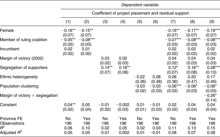
We test these various expectations in Table 3 in specifications both with and without province-level fixed effects. The dependent variable is the constituency-level conditional association between project placement and the number of supporters in the last election, as depicted in the last column of Figure 5. We address each category of explanation separately in columns 1–6 and then combine them together in a pooled model in columns 7–9. Footnote 35 In these regressions, all continuous covariates are divided by two standard deviations in order to facilitate direct comparison with dichotomous covariates (Gelman Reference Gelman2008).
TABLE 3. Explaining the Relationship Between Project Placement and Residual Support

Notes: * p < 0.1; ** p < 0.05; *** p < 0.01. Models are estimated using OLS, with province fixed effects as noted. The dependent variable is the constituency-level conditional association between project placement and the number of supporters in the last election, as depicted in the last column of Figure 5.
Turning first to the candidate’s own characteristics (rows 1–3), we find that the association between votes and project placement is weaker in constituencies with female MPs. Although this result is consistent with the claim in the literature that female politicians are less clientelistic than male politicians, we caution that the result is driven by a very small number of female MPs in our sample—just six. Moreover, all of these female MPs are politicians with national-level reputations for whom the regular rules of political behavior may not apply. Hence we hesitate to draw general conclusions about the systematic impact of gender on political favoritism from these results.
Membership in the ruling party is associated in all of our specifications with lower levels of targeting of supporters, likely because members of the ruling party have access to other sources of funding to distribute, which weakens their need to rely on the strategic allocation of CDF resources. MPs who had previously served in office, however, are no more likely to channel resources to their supporters. This is perhaps due to the offsetting effects of greater experience and lesser need to reward one’s supporters due to distributions made during prior terms.
Looking next at the characteristics of the race that brought the MP to power (rows 4 and 5), we find, somewhat surprisingly, that MPs elected in closer races are no more likely to reward their supporters than those elected in more lopsided contests (although, as we discuss below, the MP’s margin of victory has important conditional effects). Targeting of supporters is, however, strongly associated with whether or not supporters are spatially segregated from non-supporters. In keeping with the expectations outlined earlier, we find that the constituency-level association between votes and project placement is higher where segregation is higher. This is an important finding (and one that we emphasize is only possible to estimate given our fine-grained measures of both the distribution of political supporters and the locations of CDF projects).
Turning next to the characteristics of the constituency (rows 6 and 7), we find no evidence that ethnic heterogeneity is related to the degree of partisan targeting. But we do find (at least in the pooled model) that targeting is more likely where people are less spatially clustered. As explained above, this is likely because population clustering is mechanically correlated with segregation: only if people are not all living in the same place is it possible for supporters and opponents to be spatially segregated from one another.
In column 9, we investigate the interactive effects of segregation and margin of victory. Although analytically distinct, there is reason to believe that these two variables may interact in important ways. As we have argued, segregation is a necessary condition for targeting one’s supporters. But if the margin of victory is large, the MP may not have incentives to target. This explains the negative sign on the interaction between segregation and margin of victory. The interpretation of the results is that the general effect of segregation doubles in constituencies where the margin of victory is very small but goes to zero in constituencies where the incumbent won in a landslide. MPs target their supporters in constituencies where they have both the strongest incentives and the greatest ability to do so.
CONCLUSION
In this paper, we use a new dataset on the locations of CDF projects in Kenya to explore whether MPs reward their supporters. Using spatial modeling techniques and fine-grained geo-referenced data on election results, population density, poverty rates, ethnic demographics, and the locations of roads, we find only weak evidence that MPs channel projects disproportionately to areas inhabited by their political supporters, once we have controlled for other factors that affect where projects are placed. This finding presents a challenge to the conventional wisdom about the centrality of clientelistic transfers in Kenya, and of the use of the CDF program in particular as a vehicle for MPs to direct resources to their supporters (Cheeseman Reference Cheeseman, Mustapha and Whitfield2009). It suggests that some of the partisan patterns we think we see in the distribution of public resources in Kenya—and likely in other settings—may in fact be driven by underlying correlations between partisanship and other factors.
However, notwithstanding this general result, we find evidence for significant cross-constituency variation within Kenya. A major contribution of the paper is to explain this variation—and, in so doing, to underscore that different local conditions generate different incentives and opportunities for the strategic allocation of political goods. Our most important finding in this respect is the critical role played by electoral geography, which we show provides a key structural constraint on the ability of political actors to play the game of distributive politics. We demonstrate that the spatial segregation of supporters and opponents conditions an MP’s ability to reward the people who voted for him in the last election via the distribution of CDF projects. This finding suggests that future theory development on distributive politics—both in Africa and in the discipline more broadly—must consider how politicians select strategies based on such fundamental geographic constraints, rather than assuming that distributive strategies involving local public goods are available to all.
Our analysis also highlights both the payoffs and the challenges to studying distributive politics with fine-grained spatial data. On the one hand, high resolution data allows for an investigation of processes (such as project-level targeting and the role of segregation in facilitating such targeting) that research using aggregated measures is unable to address. On the other hand, high resolution data confronts researchers with inferential challenges stemming from the fact that, in most settings, the vast majority of units are likely to be uninhabited, and the resulting collinearity in any measures that depend on the presence of human populations. As higher resolution spatial data become increasingly common in the social sciences, tests of theory will encounter the fundamental indeterminacies driven by this collinearity. These are not problems easily overcome with statistical fixes. Rather, careful contextual analyses that define the conditions under which targeting can take place should be considered as central to such theory testing.
SUPPLEMENTARY MATERIAL
To view supplementary material for this article, please visit https://doi.org/10.1017/S0003055418000709.
Replication materials can be found on Dataverse at: https://doi.org/10.7910/DVN/CFTMK2.


Comments
No Comments have been published for this article.