


Historical background
Located in the Lower Silesian wilderness, the sub-camps at Czyżówek (Arbeitslager (labour camp) AL Halbau) and Karczmarka (AL Kittlitztreben) were integral to the Gross-Rosen concentration camp network, which consisted of more than 100 camps spread across what are now the border regions of Poland, Germany and Czechia (Figure 1). These camps were designed to exploit forced labour; they subjected prisoners to inhumane conditions and deprivation of basic human rights, broadly characterised as enslavement.

Figure 1. Locations of the main concentration camp KL Gross-Rosen and the subcamps AL Kittlitztreben and AL Halbau with current national borders marked in black and 1938 Third Reich borders shown by a dashed red line (figure by authors).
The Czyżówek camp, established in mid-1944, imprisoned at least 1000 individuals, mainly Poles and Russians. The Karczmarka camp, created in early 1944, detained around 1800 Jewish prisoners from various countries (Sawicka Reference Sawicka2008; Sula Reference Sula2020). Despite the differences in the prisoners’ origins, the brutal conditions did not differentiate between them and led to high mortality rates across both camps (Sawicka Reference Sawicka2008: 38, 39, 43, 44).
In February 1945, as the Soviet Army advanced, these camps were evacuated, leading to Death Marches that resulted in the deaths of about 500 men from Karczmarka and 300 from Czyżówek (Sawicka Reference Sawicka2008). After the war, the Czyżówek camp was dismantled by the early 1950s, and the site returned to forest. The Karczmarka camp was occupied by Soviet rocket troops, and the area housed numerous ammunition depots until 1993 when it was abandoned (Sula Reference Sula2020).
Research objectives and methods
These camps were chosen for their exceptional preservation, attributed to forest cover shielding them from post-war interference, although limited historical documentation meant that the camps’ locations could only be approximated. A primary goal was therefore to pinpoint their exact positions using a combination of methods (see Cox et al. Reference Cox, Flavel, Hanson, Laver and Wessling2008: 39–101; Sturdy Colls Reference Sturdy Colls2015: 143–96). Archival aerial photographs from 1948 (Czyżówek) and 1944 (Karczmarka) were analysed to map the spatial organisation of the camps. Lidar technology provided high-resolution topographic maps, revealing subtle landscape features. No geophysical surveys were undertaken at Czyżówek camp due to dense vegetation, but electrical resistivity tomography, magnetometry and ground-penetrating radar (GPR) were used in two areas at Karczmarka: around the rumoured ‘comrades’ grave’ (a brick-concrete platform) and in a large forest clearing east of the old Reichsarbeitsdienst (RAD) camp.
Excavations at both camps were limited to narrow trenches that were 1–3m in width and 1–15m in length. At Czyżówek, investigations focused on the construction methods of a southern barrack, verifying the alignment of the fence, exploring potential burial sites and examining reservoirs to the north and the elevated central area. At Karczmarka, investigations targeted anomalies identified through geophysical surveys, uncovering the remains of two barracks and the entrance to the bath-house.
Spatial organisation of the Czyżówek camp
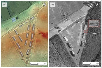
The Czyżówek camp was established on a 3.1ha irregular triangular area, bordered by dirt roads and largely surrounded by forest, except on the northern side (Figure 2). The layout, as seen in aerial photography, included watchtowers at each corner and two additional towers between them. Fourteen large barracks and one smaller building were aligned along the triangular perimeter. The barracks on the northern side were likely constructed from wood; excavations revealed preserved concrete foundations and floors, with very few bricks. Only one brick barrack, likely used by guards, has partly survived (Figure 3a).

Figure 2. Research results in Czyżówek: A) camp layout based on lidar data; B) an archival aerial photograph from 1948 with the shadow of the watchtower visible (inset) (figure by authors; photograph B reproduced with permission from the Wojskowe Biuro Historyczne in Warsaw).

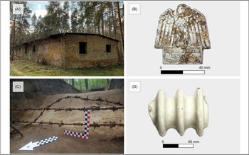
Figure 3. Discovered heritage of the Czyżówek camp: A) the only surviving barrack; B) aluminium badge commemorating the Gau Kurmark Day celebrations in Guben in 1935, found near the suspected guards’ barrack; C) a fragment of barbed wire fencing in situ, discovered in the survey trench near the western corner of the camp; D) porcelain insulator fragment found near the fencing (figure by authors).
The camp’s inner courtyard was divided into two squares, with the southern square elevated and accessible by stone stairs, possibly reflecting a hierarchical organisation or serving specific functions such as an area for roll calls. The camp was enclosed by a double-layered, electrified barbed wire fence, buried deep to prevent tunnelling. Fragments of this fence, along with insulators, were found in situ in two trenches (Figure 3c & d). To enhance security, concrete guard posts were strategically placed beyond the main perimeter.
On the eastern side, an underground structure was identified, but its function remains unclear. Close to the northern boundary was a basic sanitary facility with a concrete septic tank and larger absorption pits. Two sinkholes near the camp, identified via a 1948 aerial photograph and remote sensing data, were investigated as potential burial sites, based on testimonies provided by the residents of Czyżówek, but excavations did not reveal any burials, artefacts or anthropogenic stratigraphy.
The situation of the Karczmarka camp
The AL Kittlitztreben camp in Karczmarka evolved from a 1941 Prisoner of War camp. Prisoners were forced to work on a 400ha Luftwaffe warehouse base hidden within the forest (Sula Reference Sula2020). The camp included barracks, a sickbay, baths and workshops.
Investigations identified a RAD camp near the Kretschamberg railway station in the now-vanished village of Karczmarka, with barracks arranged around a central fountain. Aerial photographs from 1944 confirm the camp’s location west of the RAD site, showing a double barbed-wire fence, watchtowers, eight parallel barracks and additional structures (Figure 4). Two excavated barracks display similar construction to those in Czyżówek, with concrete foundations supporting floors and walls (Figure 5C). Soviets troops later repurposed existing buildings, reducing some of them in size.

Figure 4. The Karczmarka complex: A) camp layout based on lidar data; B) archival aerial photograph from 1944 (figure by authors, photograph B reproduced with permission from the U.S. National Archives and Records Administration).

Figure 5. Dark heritage of the Karczmarka camp: A) remains of a fountain in the former RAD camp; B) remains of baths; C) remains of a residential barrack; D) 3D isometric model of barrack remains found during archaeological excavations (figure by authors).
The aerial photographs also show routes, tracks, engine houses and sidings. These led to a substantial munitions area to the west, including the original Munitionslager and a V-weapon production/assembly centre, investigations of which are ongoing.
Dense vegetation limited the selection of sites for geophysical surveys. In the north-eastern section, a 20 × 40m area revealed low-resistivity zones matching a building outline, later confirmed by excavations. Neither geophysical surveys nor excavations yielded results at the ‘comrades’ grave’. About 200m south-east, sinkholes suggested sub-surface features, but resistivity results were inconsistent, likely due to dry soil. Interference on GPR and magnetometer surveys indicated subsurface metal objects and subsequent excavations revealed that the area contained post-war rubbish pits, likely associated with the Soviet troops.
Concluding remarks
This project highlights the role of archaeology in uncovering the physical realities of historical sites, even in periods for which substantial historical documentation exists. An interdisciplinary approach, encompassing various remote sensing methods, surface surveys and excavations, allowed for the identification of key elements such as barracks, latrines and fencing systems, as well as the reconstruction of spatial organisation. For the first time, the exact location of the concentration camp within the Karczmarka complex has been determined, resolving long-standing historiographical uncertainties.
Geophysical methods facilitated the identification of underground features, although their application was limited due to the terrain. Similarly, lidar data, while invaluable for landscape analyses, required ground verification. Burial sites for prisoners have not yet been identified, possibly due to landscape transformations, vegetation succession or methodological limitations. While the deliberate concealment of graves remains a possibility, this absence underscores the challenges inherent in such investigations.
This research significantly advances the archaeology of twentieth-century totalitarian regimes, highlighting both the potential and the limitations of the applied methods. Future research will extend to other sub-camps of the Gross-Rosen complex, both in Poland and Czechia.
Funding statement
The research was funded by the National Science Centre Poland as part of the OPUS scheme in the Weave program; Project Number 2021/43/I/HS3/02072.


 Open access