


Introduction
Monumental architecture exerts influence, conveying power, signalling territory, spreading social codes, invoking collective memories and generally transmitting information (Renfrew Reference Renfrew and de Laet1976; Trigger Reference Trigger1990; Dillehay Reference Dillehay and Dillehay1995; Criado-Boado Reference Criado-Boado2012; Rosenswig & Burger Reference Rosenswig, Burger, Rosenswig and Burger2012). Archaeologists have traditionally understood monumental architecture as massive construction projects whose scale and complexity exceed the bounds of practical function and have thus typically used monumental architecture as a sign of centralised, political-authority-controlled labour (Carneiro Reference Carneiro1970; Service Reference Service1975; Haas Reference Haas1982; Trigger Reference Trigger1990). Research in the Central Andes of South America has generally followed this classical model, linking monumental architecture to inequality and ranked societies (Moseley Reference Moseley1974; Moore Reference Moore1996; Shady et al. Reference Shady, Haas and Creamer2001; Stanish Reference Stanish2003; Haas et al. Reference Haas, Creamer and Ruiz2004; Rosenswig & Burger Reference Rosenswig, Burger, Rosenswig and Burger2012). Ceremonial architecture may or may not be monumental in the sense that it need not be continuously visible and thus does not necessarily evoke experiences or reactions in day-to-day life. A growing body of archaeological and ethnographic evidence from around the world indicates that hunter-gatherer groups occasionally constructed monumental architecture in the absence of residential sedentism and institutionalised inequality (Sassaman Reference Sassaman2005; Schmidt Reference Schmidt2010; Milheira & Gianotti Reference Milheira and Gianotti2018), forcing a re-evaluation of the association between monumental architecture and community power relations (Arnold Reference Arnold1993; Roscoe Reference Roscoe, Kienlin and Zimmerman2012). In the Andes, non-domestic structures identified as ceremonial or ritual, but not monumental architecture are found among hunter-gatherer groups c. 5000–3500 BP (Aldenderfer Reference Aldenderfer1990; Dillehay Reference Dillehay2011; Núñez & Perlès Reference Núñez and Perlès2018), suggesting that Andean archaeology has more to contribute to the ongoing debate.
The site of Kaillachuro (3930m above sea level), on the highest terrace in the middle Ilave drainage of the Lake Titicaca Basin in southern Peru (Figure 1), was discovered during a pedestrian archaeological survey in 1995. Nine low mounds were recorded (Aldenderfer Reference Aldenderfer2004; Craig Reference Craig2005). Mounds 4 and 6 (hereafter M4 & M6) were test excavated in 1996, 1997 and 2002 (Figure 2), and at least six human burials were found between the ash and stone layers in M4. In one, a small stone box contained the skeleton of a subadult covered in fine ochre dust and obsidian flakes. Charcoal from M4 was radiocarbon dated to 4533–4147 cal BP. Two more burials were uncovered in M6; one of a probable female with an associated stone hoe is presumed to date from the Early Formative Period (3500‒3000 cal BP) (Craig Reference Craig2005: 676–77). Dating of the burials is consistent with the diagnostic projectile points, 69 per cent of which date to the Terminal Archaic (5300–3500 cal BP) and Formative (3500–1500 cal BP) periods, also recovered from across the site. The mounds are therefore identified as funerary features of surprising antiquity. However, with dating dependent on a single radiocarbon date on charcoal and on projectile points with a wide temporal range, a more accurate chronometric determination of the features is needed to explore the age and features of this site in the Titicaca Basin.

Figure 1. The locations of Late Archaic/Terminal and Early Formative sites mentioned in the text with detail (right) of the middle Ilave Basin: 1) Kaillachuro, Jiskairumoko, Pirco, Soro Mik'aya Patjxa (SMP); 2) Ch'uxuqullu; 3) Muruqullu; 4) Chiripa; 5) Quelqatani; 6) Viscachani; 7) Kasapata; 8) Asana; 9) Hakenasa; 10) Tulán-54; 11) Tulán-52; 12) Qaluyu, Huatacoa; 13) San Bartolomé-Wiskachuni (figure by authors).

Figure 2. a) Initial excavation of Mound 4 in the late 1990s; b) the view, looking south-east, of Mound 6 prior to any archaeological intervention (figure by authors).
Provisionally, Kaillachuro suggests that monumental burial practices commenced in the Titicaca Basin during the Terminal Archaic Period, when egalitarian hunter-gatherers began to show the first signs of sedentism, population aggregation, low-level food production, expanding exchange networks and bow-and-arrow technology (Aldenderfer Reference Aldenderfer2004; Craig Reference Craig2005; Rumold & Aldenderfer Reference Rumold and Aldenderfer2016; Kitchel et al. Reference Kitchel, Aldenderfer and Haas2022; Flores-Blanco et al. Reference Flores-Blanco, Cuellar, Aldenderfer, Stanish and Haas2024). This is 1500 years earlier than the Early Formative Period monumental architecture and funerary structures found at Chiripa, Qaluyu, Huatacoa and San Bartolomé-Wiskachuni (Hastorf Reference Hastorf2003, Reference Hastorf, Silverman and Isbell2008; Herhahn Reference Herhahn2004; Cohen Reference Cohen2010). Determining the chronology and functionality of Kaillachuro is thus crucial to our understanding of emergent complexity in the Titicaca Basin. By challenging the assumption that the ability to generate resource surpluses was a prerequisite for the construction of monumental architecture, Kaillachuro offers the opportunity to explore other forms of monumentalism.
Materials and methods
Kaillachuro was surveyed and excavated during six field seasons (Figures 3 & 4). This study includes both unpublished material and new data from Kaillachuro. Test excavations were conducted in a 4m2 unit on M4 in 1996 and 1997, a 7 × 1m trench at M6 in 2002 and the original names of the levels, identified using Roman numerals, are preserved here. A pedestrian systematic survey in 2019 and excavations totalling 96m2 in 2021, 2022 and 2024 targeted mounds, artefact scatters between mounds and surface areas without artefacts. Archaeological stratigraphic principles were followed to record each stratigraphic unit (SU) and for subsequent periodification into phases and events (Harris Reference Harris1989). Each excavated block had its own SU numbering. All excavated material was sifted for artefacts using a 1mm mesh screen. Radiocarbon dating, mostly on bone, was conducted on materials from earlier and more recent seasons. Dates were calibrated using OxCal v4.4 (Bronk Ramsey Reference Bronk Ramsey2021) (see online supplementary material (OSM) Table S1).

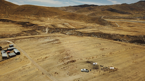
Figure 3. A south-east/north-west aerial perspective of the Kaillachuro site, located on an alluvial terrace in the highland Ilave Basin. The image shows archaeological excavations in mounds 4 and 6 (figure by authors).
Results
Site structure and artefact assemblage
The survey revealed spatial relationships between mound features and artefact concentrations over a 3ha site (Figure 4). Projectile points are primarily associated with burial mounds M4 and M6, while ground stone tools are found in mounds and in non-mound areas. Mounds form a north-south alignment, and M2–M6 partially surround an open central area. More than 76 600 artefacts were recovered, mostly from subsurface contexts; 97 per cent of these were debitage from lithic reduction. Bone, plant remains, ceramic sherds, ochre and ground stone tools were also recovered. Ongoing zooarchaeological and archaeobotanical analyses have so far identified camelid bones and burnt seeds (Chenopodiaceae). Most of the diagnostic projectile points date from the Terminal Archaic and Formative periods (Klink & Aldenderfer Reference Klink and Aldenderfer2005). Ceramic sherds were predominantly found in the upper layers, which is the plough zone, and 42 per cent are of late ceramic styles, representing minimal later activity at the site corroborated by two radiocarbon dates from intrusive Inca Period burials in M1 and M6 (D-AMS 047367, 448–355 cal BP and D-AMS 052911, 520–462 cal BP, respectively; see Tables S1 & S2). Only 6.6 per cent of the pottery recovered is from the Formative Period. These typological dating results indicate that the site was used between the Terminal Archaic and the Early Formative periods (5300–3000 cal BP), with a minor Inca intrusion in M1, M6 and M10 (Figure 4).

Figure 4. Topographic map of Kaillachuro. A 3ha scatter of Archaic and Formative materials is shown by the red polygon. Hotspot analysis highlights surface-collected artefact density. As Mound 10 is mostly an Inca-Period occupation, it is plotted outside the polygon (figure by authors).
Stratigraphic sequence
Excavation units were placed in four mounds (M1, M4, M5 & M6) and three extra-mound contexts (see Figure 4). M4 was the most intensely excavated mound, exposing a complex stratigraphic sequence involving multiple episodes of construction, use, accumulation and renewal (Figures 5 & 6), and the remains of at least 25 individuals—from old and new excavations—were encountered throughout the sequence. Most of these burials are secondary and fragmented, although there are at least two primary burials (the stone box burial and burial 5), one found during excavations in the 1990s and another in 2022. Many burials are single interments, although there are also instances of multiple burials (e.g. burials 3 & 4). Based on these excavations, five phases of use can be identified at Kaillachuro (Table S2).

Figure 5. Plan of the excavation units and stratigraphic sections of Kaillachuro. Section 1 shows the south-east/north-west stratigraphic section of Trench 1 excavated during the 1990s. We maintain the original labelling of the strata (e.g. Level IV), while the burials are prefixed with the letter B (e.g. B5). Section 2 shows the south–north stratigraphic section of the central part of Mound 4. The stratigraphic units (SU) and main archaeological features are indicated. In both sections, radiocarbon dates are shown in calibrated BP age ranges (figure by authors).

Figure 6. Burial features and finds from M4: a) the earliest unexcavated burial pit (1, a projectile point; 2, a green bead); b) Burial 2 in the initial mound (3, a golden stone bead; 4, an obsidian point found below the tomb); c) a stone-box with a child burial; d & e) a cist containing the skeleton of a child covered in red ochre (5, a stone bead; 6, a chert projectile point). Also shown, the stone platform on M6 is enclosed by thick stone walls (f) (figure by authors).
Phase 1 (5300–5000 cal BP)
Several burial pits were cut into in SU-7 of M4. The best-preserved was burial 2 (in pit SU-19, measuring 0.6 × 0.4m across and 0.3m deep), containing only a single femur from an adult, directly dated to 5294–4963 cal BP. This pit was filled with clay (SU-20), from which lithic debitage, a green chert bead and a round-shouldered, brown-chert foliate projectile point were recovered. Small stones were placed around the circumference of the pit (Figure 6a). An upper, horizontal clay surface is associated with this burial feature, containing a shallow hearth (SU-9), which consisted of a greyish deposit of ashy soil, charcoal and fine gravel.
Atop these interments, sand and clay fills (SU-4, 6 & 18) formed a mound 0.8m tall. The fill contained several artefacts, including stone tools and numerous fragments of human bones. A secondary burial in the centre of the SU-4 deposit (burial 4; Figure 6b) was directly dated to 5294–4977 cal BP, suggesting near contemporaneity with the underlying burial event.
Phase 2 (4800–4100 cal BP)
A 0.3 × 0.3m stone box with a prepared floor of purplish-brown soil and a double wall of vertically placed, angular grey and white rocks intrudes into the earlier levels of M4 (Figure 5: Section 1 & Figure 6c). The soil at the base of the box contained fragments of a small human skull, maxilla and deciduous teeth, suggesting the burial of a subadult. Obsidian flakes and charcoal fragments covered the floor. A radiocarbon sample from the fill is dated 4533–4147 cal BP. Stone slabs and red soil covered this box.
At M6, charcoal from a hearth provides a date of 4824–4570 cal BP. This phase also includes three dates from extra-mound contexts. At the northern end of the Kaillachuro site, within our South-Central unit in Block 4, an ashy layer (0.3m below the surface) with burned stones and ground stones is dated at 4654–4519 cal BP. A 2 × 2m unit in the open area north-east of M7 revealed three oval-shaped pits with sparse charcoal remains, dating to 4649–4512 cal BP. Ash deposits in a trench between M4 and M6 also contained a large volume of debitage and a camelid bone, which returned a date of 4827–4576 cal BP.
Phase 3 (3800–3500 cal BP)
A second, 1.2m-tall mound was formed at M4 as the result of at least two clearly discernible events of activity and fill deposition. At the deepest level of the eastern side of the mound (Figure 5: Section 1), a burial pit (B7) cuts through the Phase 1 levels. The 0.9m-diameter circular burial pit was filled with highly compact clay soil, medium-sized stones, at least one large, long stone slab and fragments of human bone (level VII). Some ceramic sherds, four obsidian and chert projectile points (Types 5A, 5B and 5D), one stone bead and several lithic flakes were also recovered from the fill. A human tooth, unearthed in 1997 on the external horizontal clay interface, provides evidence of the removal of earlier strata to construct B7. This tooth produced a date of 5294–4966 cal BP, placing it within Phase 1. A copper disc was discovered adjacent to this tooth, but the archaeological context is not secure, and it seems probable that this material is either from one of the disrupted burial contexts below or from the upper stratum. At least two levels of 20mm-thick reddish-yellow clay (levels V & VI) were deposited on top of the burial pit. These contain numerous chipped stone tools (points and scrapers) and fragments of human bones, one of which dates to 3719–3571 cal BP. The accumulation of deposits continued, with levels III and IV (each approximately 0.1m thick) subsequently added, perhaps as activities around the burial mounds persisted.
At the centre of M4, we found four levels of semi-compact, very dark grey organic soil (SU-3) (Figure 5: Section 2). In the deepest of these levels, we uncovered two curved stone alignments that seem to form poorly defined structures. Above, three arbitrary levels follow one another (SU-3b, c, d) containing charcoal, ochre, an abundance of debitage, flakes, cores, projectile points, bone fragments and, for the first time, pottery sherds. A human bone recovered from SU-3 dates to 3588–3482 cal BP.
M6 was also being used during this phase; we recovered several small fragments of human bone from SU-9, with one of them dating to 3831–3681 cal BP.
Phase 4 (3500–3000 cal BP)
In this phase, we see three modifications to M4. First, on the south-east side of the mound, previous deposits were dug out to a depth of 1.5m from the modern surface to build a semi-subterranean cist measuring 0.8 × 0.4m across and 0.15m deep, within which a child was buried (burial 5) (see Figure 5: Section 2). The cist walls were built with local volcanic rock and two bright white limestone rocks, using grey mortar as bonding and plastering agents (Figure 6d). The floor of the chamber was covered in compact, yellowish-red clay (SU-15). On this floor, the partial skeleton of a subadult was found flexed on the right side and covered in red ochre. Two direct dates on bones place the interment between 3466 and 3132 cal BP. A compact, clayey, ochre-mixed and reddish-brown layer of sediment covered the body (SU-13). This infill contained lithic flakes and two Terminal Archaic–Formative Period (5B & 5D) silex and obsidian projectile points (Figure 6 no. 6). A 20mm-deep layer of dark brown ash, charcoal, fine gravel, silex lithic debris and human bone fragments was later placed on top of the cist as part of a separate burning event (SU-11). Excavation in the 1990s on the east side of the mound revealed secondary burial B5, which cut into level III and contained only a few human bones, a greenstone bead and a ceramic sherd. The burial was lined with rocks and filled with a silty clay deposit, incorporating a small amount of ash (Figure 5: Section 1).
Second, four long granodiorite slabs and a clay fill (SU-10), containing the remains of at least three incomplete individuals (burial 3), sealed the previous burial 5 cist (Figure 6e). Direct dating of two human bones from this fill yielded age estimates of 5195–5050 and 3267–3137 cal BP, respectively.
Third, several levels of ash and debris (SU-2) covered all these features to renew the mound. These levels contained thermofractured rocks, ground stones and a few pottery sherds (Figure 5: Section 2). Identified as level Ia during test excavations on the east side of the mound in the 1990s, secondary burial (B4) cuts into this fill (Figure 5: Section 1).
During this phase in M6, a rectangular stone platform surrounded by thick stone walls (0.4m in width) was constructed, forming a large enclosure whose limits have yet to be defined (Figures 6f & 7). The walls are made of granodiorite rock and grey mortar. We estimate the platform at 0.2m high and about 2m long. A surface hearth, containing bird bones, on the floor associated with the platform wall dates to 3385–3172 cal BP. In 2002, a trench excavated into this mound revealed at least two secondary burials (Craig Reference Craig2005), which were in the upper fill. At least one of these burials is intrusive (see Table S1).

Figure 7. The stone platform at the top of Mound 6 is surrounded by thick stone walls and a compact surface. These are indirectly dated to the Early Formative Period (c. 3300 cal BP). Two burials have been found in the final fills covering this area, at least one of which is invasive (Craig Reference Craig2005; 493 cal BP). Decimal numbers placed on the map indicate reference elevations in metres above sea level (e.g. 3930.58) (figure by authors).
At c. 3000 BP, both mounds were abandoned. In total, M4 reached a height of at least 1.5m, and M6 at least 1.7m.
Phase 5 (520–400 BP)
After their abandonment, the mounds were still occasionally used as burial places. In M1 and M6, we discovered intrusive Inca burials (see Tables S1 & S2).
Sequence summary
Kaillachuro was inhabited between 5300 and 3000 BP (Figure 8 & Table S2). Early activity at the site included the placement of burials and associated deposits, which formed a low mound about 1m high (M4). During a second phase of activity, between 4800 and 4100 cal BP, a section of the mound fill was removed and at least one stone box was constructed within it to contain the burial of a child. The role of M4 as a tumulus was reprised alongside the use of M6 300 years later, in Phase 3, when M4 reached a height of 1.2m (3800–3500 cal BP). During Phase 4, beginning at 3500 cal BP, substantial transformations were made at Kaillachuro. A burial cist was built at the base of the M4, cutting into it, and a low platform was built within an enclosure at the top of M6. The site was abandoned after 3000 cal BP but was occasionally used for burials in the Inca Period (500–418 BP).

Figure 8. Radiocarbon dates from Kaillachuro (n = 19). Calibrations employ OxCal v4.4 (Bronk Ramsey Reference Bronk Ramsey2021), r:5 SHCal20 atmospheric curve (Hogg et al. Reference Hogg, Heaton, Hua, Palmer, Turney, Southon and Wacker2020). Dates from the Archaic and Formative periods are included. For the complete list see Table S1 (figure by authors).
Discussion
Mound formation
The stratigraphic sequence and radiocarbon dates presented in this article reveal that the mounds at Kaillachuro were formed over a period of more than 2000 years, beginning more than 5000 years ago. This formation process is consistent with slow and gradual mound growth on the Andean coast (Vega-Centeno Reference Vega-Centeno2007), the Titicaca Basin (Hastorf Reference Hastorf2003; Cohen Reference Cohen2010) and Araucanian ethnohistorical data from Chile, where mounds resulted from multi-year postmortem ceremonies (Dillehay Reference Dillehay and Dillehay1995).
Kaillachuro mounds formation involved both depositional and renovation events. M4 consists of at least three overlapping mounds of ash sediment, burned stones, secondary human burials and animal bone fragments from domestic refuse, funerary activities and possibly feasting. In the years after the placement of the first burial, postmortem actions may have created the first mound. This would explain why radiocarbon evidence cannot distinguish between the burials in the layers of this first mound and the burial pits below it. Alternatively, some mound fill may be formed from prior features that were removed for the construction of subsequent structures, such as the stone box and cist. This renovation activity would explain the early date of the SU-10 fill (5195–5050 cal BP), which is older than the directly dated burial it covers and contradicts the otherwise robust Early Formative association. Such processes did not affect the entirety of M4, however. Figure 5 shows that on the north side of the mound, horizontal deposition in SU-3 and SU-4 includes several levels that may have resulted from repeated activity at the mound, including an in situ burial in SU-4. On the south side of M4, bones found in pit SU-19 are highly fragmented, suggesting that the fill had been disturbed perhaps due to a mortuary ritual of removal of the dead.
Details of the construction of M6 remain uncertain, but recent excavations suggest that the mound is the result of a series of midden deposits during the Terminal Archaic Period, culminating in ceremonial masonry architecture during the Early Formative Period. This architecture includes a quadrangular platform within an enclosure with thick, stone walls.
Thus, (re)interpretation of stratigraphy and radiocarbon dates from excavations at Kaillachuro indicates that the first two M4 mounds date to the Terminal Archaic Period, while the third dates to the Early Formative Period, when M6 was also restructured with formal architecture.
Why the mounds were built is difficult to determine, though they share some similarities with other South-Central Andean hunter-gatherer ceremonial features (Table 1). The burials and their associated mortuary features provide evidence for the existence of funerary rituals from the inception of M4. The earliest interment is a simple pit burial from 5300 cal BP, though a projectile point (Type 2A) in the pit fill initially suggested an Early/Middle Archaic Period (9000–7000 cal BP) association. It is possible that this inclusion was deliberate, intended to emphasise traditional hunting during a time of innovation, but it is also possible that the artefact entered the pit incidentally during infilling. These burial pits are similar to those found near the houses at the nearby site of Jiskairumoco (Aldenderfer Reference Aldenderfer2004; Craig Reference Craig2005) and at other Early and Middle Archaic period sites, such as Soro Mik'aya Patjxa and Wilamaya Patjxa, up to 9000 cal BP (Haas & Viviano Reference Haas and Viviano2015; Haas et al. Reference Haas2020).
Table 1. Ceremonial features at the Kaillachuro site throughout its sequence, and at contemporaneous sites.

At Kaillachuro, the early burial pits represent the beginning of a long and distinct funerary tradition, and the repetition of ceremonial practices resulted in the formation of mounds. One such recurring practice is a burning event, identified in at least three instances at M4. A shallow hearth filled with burned plant matter (SU-8 & SU-9) appears to have been part of a ceremonial act surrounding burial 2, while a burning event in the ochre matrix of the stone box floor produced its distinct violet colour. After the burial cist was sealed in Phase 4, plant material was burned on top of it. Such burning rituals are common in other Andean Altiplano societies during the Formative Period (Hastorf Reference Hastorf2003; Cohen Reference Cohen2010; Goodman-Elgar et al. Reference Goodman-Elgar, Langlie, Davenport, Moore and Hastorf2023).
Excavations in M6 suggest a somewhat different narrative. The near complete absence of funerary deposits in Archaic Period contexts strongly suggests that this was not a burial mound, but rather the outcome of the successive deposition of discarded material from food consumption and ceremonial activities.
The construction of a masonry cist tomb in M4 and a thick-walled enclosure and platform on M6 are distinctive features of funerary and ceremonial practice at Kaillachuro. Cist construction is also documented at San Bartolome-Wiskachuni during the same period; similarities are seen in the choice to reconfigure an ancient site, the cist form, the preference for individual burials, the positioning of the deceased in a flexed posture on their right side, the paucity of inorganic offerings and the use of ochre and stone-slabs coverings (Herhahn Reference Herhahn2004). It is possible that the platform at M6 served as a ceremonial focus due to its proximity to burning areas, such as a burn pit with bird bones; it is also the only above-ground masonry structure at the site. Moreover, this platform was used as a funerary place many centuries after its abandonment. An intrusive burial dates to the Inca Period, which is in line with the Andean tradition of reusing early sites for later burials (Flores-Blanco et al. Reference Flores-Blanco2022). Although this result does not rule out the possibility of early burials, as has been documented on a platform in Huatacoa (Cohen Reference Cohen2010), or its utilisation as a kind of shrine, further research is essential to determine the precise function of this architectural feature.
The mounds may have slowly grown in height as waste from funeral and post-funeral ceremonies was left behind. Day of the Dead celebrations in the Andean tradition include food preparation and the ritual sacrifice of camelids. Leftovers from the meal are also buried with the deceased (Aranguren Paz Reference Aranguren Paz1975; Allen Reference Allen2012). At Kaillachuro, heat-fractured black stones, ashy soils, and camelid and bird bones in pits are found in the last two phases of mound accumulation in both M4 and M6. These may be remnants of ceremonies performed around the mounds. Similar deposits are found at other sites in the South-Central Andes, indicating such mounds served as community gathering places (Bauer Reference Bauer2007; Cohen Reference Cohen2010; Núñez et al. Reference Núñez2017; Núñez & Perlès Reference Núñez and Perlès2018; Power et al. Reference Power2022).
Thousands of pieces of debitage, hundreds of ground stones and ash fills further provide indirect evidence for domestic and productive activities at Kaillachuro. Most are found both in the spaces between the mounds and in the later fills that formed M4 and M6, suggesting that undiscovered dwelling and workshop areas may exist nearby. The coexistence of religious and economic activities in the Andes is widely recognised (e.g. Dean & Kojan Reference Dean and Kojan2001; Allen Reference Allen2012); at Kaillachuro, available evidence suggests that this coexistence arose during Phase 3, followed by more prevalent activity in Phase 4.
At nearby Jiskairumoko, houses and burial pits coexist in the same area (Craig Reference Craig2005). No houses have yet been found at Kaillachuro, but extensive modern agricultural activity and site reuse/destruction complicate this search. The pit-houses at Jiskairumoko are found at a depth of less than 0.3m; similar structures at Kaillachuro have probably been lost owing to mechanised ploughing. A large ashy layer dating to 4654–4519 cal BP in the northernmost excavated unit may be the remains of a domestic context. Domestic features might be preserved below burial mounds—some stone alignments in SU-3 of M4 may have been residential walls. Additional explorations in Kaillachuro may yield preserved houses, and a complete lithic analysis could clarify the role of associated lithic tools.
Ritual and the South-Central Andean Neolithic
Our research challenges the view that early societies needed to meet at least one of the conditions traditionally associated with the Andean Neolithic—sedentism, agriculture and social inequality—before constructing monumental architecture (Shady et al. Reference Shady, Haas and Creamer2001; Haas et al. Reference Haas, Creamer and Ruiz2004). Instead, we show an alternative pathway to mounded architecture, emphasising the significance of community memory, which pre-dates other classical domains of socioeconomic complexity. In the South-Central Andes, hunter-gatherers engaged in complex socioeconomic activities without an agricultural economy, residential sedentism and institutionalised inequality (Aldenderfer Reference Aldenderfer2004; Aldenderfer et al. Reference Aldenderfer, Craig, Speakman and Popelka-Filcoff2008; Flores-Blanco Reference Flores-Blanco2014, Reference Flores-Blanco2024; Núñez et al. Reference Núñez2017; Núñez & Perlès Reference Núñez and Perlès2018; Kitchel et al. Reference Kitchel, Aldenderfer and Haas2022; Power et al. Reference Power2022). Thus, it is crucial to investigate what triggered these social and economic developments.
Kaillachuro illustrates, for the first time, a similar pattern in the Titicaca Basin where the construction of monumental architecture emerged part-and-parcel to a corpus of complex socioeconomic behaviours—especially early agropastoralism, reduced mobility and long-distance exchange—rather than as a product of them. These findings reveal that relationships between the living and dead began to change during the Terminal Archaic Period.
As in previous archaeological periods, the deceased were buried with ceremony but, for the first time, their presence was rendered visible in the landscape. The burial mounds were monuments that, whether intentional or not, conveyed signals to the living. This practice was more prevalent during the Formative Period, when rites involving human remains were crucial to community development (Hastorf Reference Hastorf2003). Kaillachuro shows that this communal behaviour began 5000 years ago in the Titicaca Basin, which is 1500 years earlier than previously thought. Our findings thus add to the growing consensus that early monumental structures either precede or coincide with emergent complexity, suggesting that ritual was essential for such socioeconomic transformation, perhaps acting as a catalyst for population cohesion (Bonnier Reference Bonnier1988; Aldenderfer Reference Aldenderfer1990; Dillehay Reference Dillehay2011; Núñez et al. Reference Núñez2017; Stanish Reference Stanish2017; Núñez & Perlès Reference Núñez and Perlès2018).
Conclusion
Excavations at Kaillachuro reveal that activities relating to the burial or commemoration of the dead inspired the construction of monumental architecture that did not necessarily reach massive dimensions nor imply the materialisation of power. Far from resource surpluses or centralised labour, it was the memory of their ancestors that drove mound construction at Kaillachuro. Hunter-gatherer burial practices in the South-Central Andes may thus have contributed to socioeconomic transformations associated with the Neolithic, but the precise mechanism(s) through which these practices facilitated this development remains unclear.
Acknowledgements
We appreciate the Jachaccachi Aymara community's and Incacoña (especially Mateo) family's fieldwork participation. Additionally, thanks to all the colleagues and friends (L. Cuellar, M. Romero, K. Toledo, G. Irureta, E. Champi, C. Chavez, M. Hall, L. Hinostroza, L. Zela, A. Concha & R. Carazas) who helped us with this research. Peruvian Ministry of Culture authorisation enabled the research. Many thanks to Randall Haas and Jelmer Eerkens for their comments.
Funding statement
The initial phases of excavation were funded by the H. John Heinz III Charitable Trust and the National Science Foundation (SBR-9816313). The Rust Family Foundation (RFF-2021-146 & RFF-2023-212), American Philosophical Society (Lewis and Clark Fund 2021), Instituto Francés de Estudios Andinos - Carlos Brignardello Grant, National Geographic Society (EC-97351R-23) and UC Davis also sponsored new research at Kaillachuro, which was part of the PhD research of the first author of this article.
Online supplementary material (OSM)
To view supplementary material for this article, please visit https://doi.org/10.15184/aqy.2025.40 and select the supplementary materials tab.


 Open access