


Introduction
Numerous alignments of standing stones occupy areas of Brittany, particularly in the Morbihan, where a large megalithic complex stretches from Carnac/La Trinité-sur-Mer to Erdeven, featuring multiple alignments and thousands of standing stones in a coastal area more than 10km wide (Cassen et al. Reference Cassen, Boujot and Grimaud2021). While large parts of this complex are still visible today and attract thousands of visitors every year, others were removed in (pre)history and often reused, for example, as building materials. As a whole, this area forms a unique and complex early megalithic landscape consisting of standing stones, megalithic standing-stone ‘enclosures’, tombs and tumuli, and hoards, together containing the highest reported density of European greenstone artefacts, including Alpine greenstone and variscites from different regions of Iberia (Pétrequin et al. Reference Pétrequin, Cassen, Errera, Klassen, Sheridan and Pétrequin2012; Querré et al. Reference G., Cassen and Vigier2019).
Since the nineteenth century, a lively debate has centred on the origins of the megaliths in Western Europe. Recent studies tend to confirm the emergence of megalithic traditions in the first half of the fifth millennium BC in the bay of Quiberon and the Gulf of Morbihan (Schulz Paulsson Reference Schulz Paulsson2019). However, the origins and precise chronology of construction remain ambiguous for several reasons. The early nineteenth-century excavations in this area, although conducted using relatively modern standards, nevertheless suffered from patchy documentation, particularly regarding the context of cultural material. In addition, organic material, and particularly bone, does not survive in the acidic soils of the Morbihan, limiting opportunities for radiocarbon dating.
At Le Plasker, recent rescue excavations have revealed a previously unknown section of this large megalithic complex (Figure 1): well-preserved alignments of standing stone pits and cooking pits surrounding a monumental tomb. Forty-nine new radiocarbon dates were obtained, providing one of the largest radiocarbon sequences for western France—spanning the Late Mesolithic (5600–4900 cal BC) to the Middle Neolithic (Figure 2)—and thus making a substantial contribution to the debate surrounding the emergence of megaliths in both the Carnac region and Europe more generally. Together, the excavations and the radiocarbon sequence also shed light on the sociocultural landscape of early megalithic societies in Brittany.

Figure 1. Above) distribution of standing stones in the Carnac area; below) distribution of stelae and cists under mounds between the Etel and Crac’h rivers, with the main alignments highlighted (after Cassen 2021: 34, 126) (figure by authors).

Figure 2. Graphic of Le Plasker’s chronology (figure by A. Blanchard & J.N. Guyodo).
Le Plasker
Rescue excavations were conducted by Archeodunum, under the leadership of Audrey Blanchard, in the town centre of Plouharnel over a three-month period in autumn 2020 in advance of the development of a new 7000m2 business park (Blanchard et al. Reference Blanchard2023). It is highly likely, however, that the original site extended beyond the excavated area. Situated in a relatively flat area, the site is located in a palaeovalley, on the edge of a granitic plateau bordered by the Bay of Quiberon to the south and the Atlantic Ocean to the west, with the ridge line running north-northwest to south-southeast. The site is 2km west of the Le Ménec alignments in Carnac and 1.4km south-east of the Sainte-Barbe alignment in Plouharnel. The nearest alignment is Le Vieux Moulin, 800m to the north-west.
The structures discovered at Le Plasker are situated on a south-west-facing slope, overlooking the sea. A pre-megalithic but already monumental tomb (with stone cist covered by a mound) is located to the south-east, beneath the ridge line upon which the lines of standing stones were erected (Figure 3). The present seashore lies approximately 1km from the site, but the sea level during the fifth millennium cal BC would have been approximately 5m lower and the shoreline perhaps several hundred metres further away. The relatively flat local topography means that the sea, even at a reduced level, was visible from the highest point of the site, allowing the lines of stones to be, in turn, visible from the sea.

Figure 3. Plan of Le Plasker site, detailing features and associated calibrated radiocarbon dates (figure by A. Blanchard & F. Montassier).
The in-depth excavation at Le Plasker provides a valuable opportunity to explore unresolved research questions (e.g. dates of construction and function) surrounding megalithic complexes using modern excavation methods and analytical techniques. The complex consists of a pre-megalithic monumental tomb, substantial cooking pits and aligned foundation pits for standing stones that originally formed one part of the well-known complex alignments of Carnac.
Material and methods
Detailed excavation was supplemented by a wide range of analyses, including geological, geomorphological, micromorphological and anthracological (see online supplementary material (OSM)). Few artefacts were recovered during excavation, principally lithics and ceramic sherds, including a grooved arch motif attributed to the Late Castellic period (4400/4300–4000/3850 cal BC; Figure 2; cf. Bailloud Reference Bailloud1975; Cassen Reference Cassen2000, Reference Cassen2009).
Radiocarbon dates are based on charcoal samples from various archaeological features, including a circular ditch, the cist and associated monumental mound, standing-stone foundation pits and cooking pits. The samples were systematically selected from the lower levels of fills, most often from stratigraphic units sealed by a stone-block level. Analysis of the charcoal identified short-lived species (e.g. hazel or the sapwood of oaks) that were selected preferentially for radiocarbon dating. From a total of 33 features, 49 radiocarbon dates were produced (see Table S1). Discordant (recent) radiocarbon dates were obtained for 10 of the 33 structures. These results could be discounted for five structures, as we were subsequently able to obtain new Neolithic dates from different samples more consistent with the type of structure.
A high precision chronology is established for the horizontal stratigraphy through the application of Bayesian modelling for at least 30 radiocarbon dates, using formal outlier analysis. Dates are modelled using OxCal v.4.4.2 (Bronk Ramsey Reference Bronk Ramsey2020) and calibrated with the IntCal20 calibration curve (Reimer et al. Reference Reimer2020). This sampling strategy and analysis revealed six main phases and seven subphases for the megalithic occupation of Le Plasker (Figure 4, Table S3).

Figure 4. Bayesian model showing posterior density distributions of radiocarbon dates for the horizontal stratigraphy. Model agreement: Amodel = 105, Aoverall = 98.7 (see OSM) (figure by B. Schulz Paulsson).
The Le Plasker phases
Phases 1 and 2: Late Mesolithic 5699–5621/5563–5075 cal BC
The earliest occupation of the site dates to the end of the Mesolithic period (phase 1 Mesolithic occupation, 5699–5621 cal BC, 95.4% probability; Figures 3, 4 & 5). At this time, an oval feature was dug out (5.70 × 5.10m) with a peripheral ditch containing several granite blocks maybe intended to stabilise wooden poles. Three monoliths or small potential standing stones were discovered in the immediate vicinity of the ditch—but not inside it. The monoliths differ in volume, size and position from the other blocks present in the ditch, which leads us to associate them with this first occupation. Discovered in an oblique to subvertical position, they all rest on a sedimentary horizon underlying the nearby cairn, indicating that they were positioned prior to its construction. One of the monoliths is potentially anthropomorphic in form, featuring a triangular shape and a wide flat base with two tenons. The only other find from the Mesolithic period is a flint arrowhead (triangle scalene) in the northern part of the site. The most plausible interpretation is that the ditch defines a Mesolithic hut.

Figure 5. Plan of Mesolithic remains and stratigraphic sections of the Mesolithic ditch; a) monolith with a triangular shape and wide, flat base with two tenons (figure by A. Blanchard & J.N. Guyodo).
Five dates indicate a time interval of 5681–5621 cal BC (95.4% probability); suggesting a brief occupation. Three samples indicate a subsequent phase of activity at the end of the Mesolithic (phase 2 Mesolithic occupation, 5563–5075 cal BC, 95.4% probability; Figure 3).
Phase 3: pre-megalithic monumental tomb 4790–4640 cal BC
After a hiatus of about 300 years, the site was reoccupied at the onset of the Middle Neolithic. A grave monument was erected directly on top of the remains of the Mesolithic structure, consisting of a small, circular mound (3.3m diameter) that covered a central, quadrangular dry-stone cist oriented north-west to south-east and built above ground (phase 3 mound with cist, standing stones and first activities in the sector, 4791–4640 cal BC, 95.4% probability; Figures 3, 4, 5 & 6). The dimensions of the cist (0.7 × 0.9m) suggest that it was originally intended for a single individual buried with the lower limbs strongly flexed, but no bones or grave deposits are preserved inside. Micromorphological analyses indicate that the dry-wall cist was originally covered with organic material; whether this covering was intentional or not is difficult to determine as the material deteriorated rapidly after deposition. Charcoals from ash or oak sapwood found inside the cist (feature 70) are radiocarbon dated to 4791–4686 cal BC (combined; 95.4% probability), directly linking it to the initial construction of the monument and/or burial rites. The remains of the mound, consisting of locally quarried granite, stand at a height of 0.15m, covering an area of 16m2. The geomorphological analysis confirms a level of trampling at the top of the construction (Figure 7).

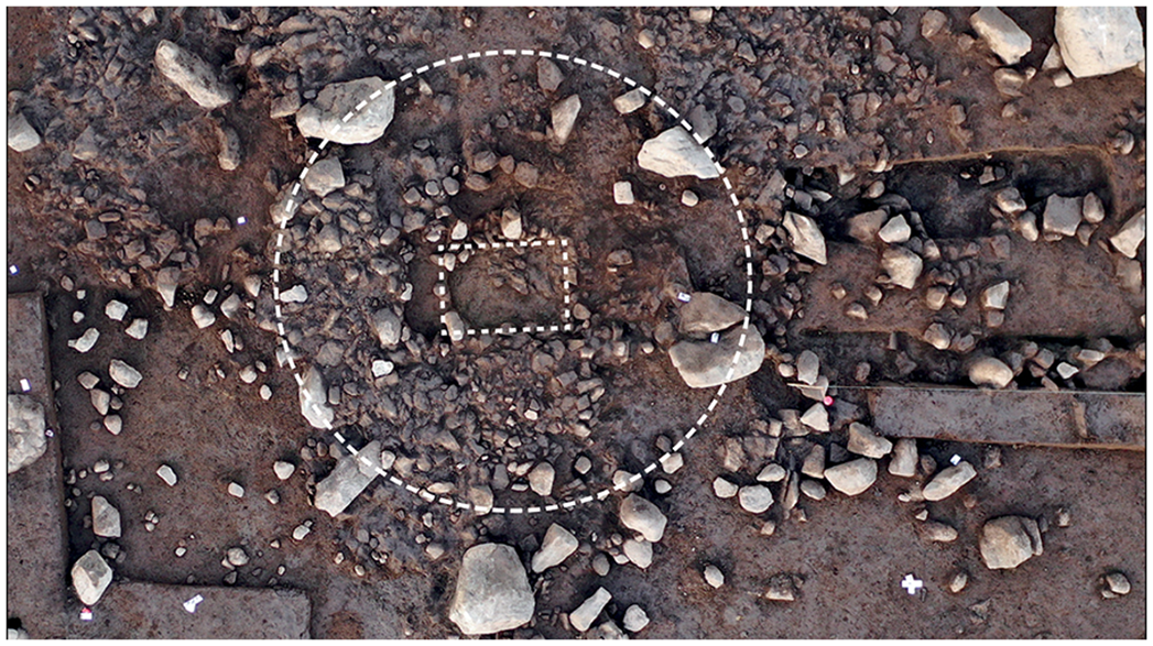
Figure 6. Aerial view of the funerary monument (figure by A. Blanchard).

Figure 7. Plan and stratigraphic section of the funerary monument (figure by A. Blanchard & F. Montassier).
Traces of 46 monoliths are noted within a 20m radius around the southern part of the funerary architecture (Figure 8), to the south of a west–east axis that passes through the middle of the cist. All monoliths were found with their natural surfaces facing upwards in the original position of the outcrop (Guyodo & Mens Reference Guyodo and Mens2013). This arrangement, possibly chosen for symbolic or aesthetic reasons, suggests a contemporaneity with the tomb. Six large oval-shaped pavements (1–2m in diameter) were also positioned around the mound, one of which yielded a radiocarbon date contemporaneous to the cist. Four of these pavements seem to have been the foundations of standing stones with flat bases, while two are more likely to be spoil from the construction or the partial demolition of the mound. Two cooking pits containing charred stones (F52 & F81), situated at a distance to the north and east of the burial monument, provide evidence of contemporaneous on-site activities (Figure 3).

Figure 8. Above) Aerial view of monoliths around the funerary architecture; below) a plan showing the distribution of blocks and structures near the monument (figure by A. Blanchard & J.N. Guyodo).
Phase 4–5: alignments 4670–4250 cal BC
Shortly after, or possibly at a similar time to, the construction of the tomb, standing stones were erected to the west of the site forming several north–south-oriented alignments (phase 4 alignments, 4668–4368 cal BC, 95.4% probability; Figure 3). These alignments were created during several construction subphases. Although the standing stones are no longer present on site, foundation pits containing large wedging stones remain. These pits differ from the oval-shaped pavements surrounding the mound; they resemble standing stone pits found at the Table des Marchands in Locmariaquer (Cassen Reference Cassen2009).
The foundation pits at Le Plasker, with an average diameter of 1.8m, suggest the presence of large standing stones (Figure 9 ; Table S2). These pits contained a substantial quantity of granite blocks (averaging 60 blocks or more than 100kg of material). The asymmetrical profiles of these blocks would have facilitated the placement and the lifting of the standing stones. Additionally, the arrangement of the blocks reveals a central empty space, while the included vertical blocks used as a stop for the straightening process and rubble would have served to prevent any lateral movement of the standing stones. Charcoal samples from short-lived trees such as broom, maloid, hazelnut and oak sapwood were collected from the fill of nine foundation pits, providing radiocarbon dates that largely indicate activity between 4668 and 4368 cal BC (95.4% probability).

Figure 9. Characterisation of the pavement, foundation pits and cooking pits (figure by A. Blanchard & F. Montassier).
Cooking pits containing charred stones were created in the immediate vicinity of the standing stone alignments and at approximately the same time, although two may be slightly earlier in date. The cooking pits are smaller than the foundation pits (averaging 1.47m in diameter) and contain ruby granite blocks that are either standalone but contiguous or arranged in a ring on top of layers of charcoal (Table S2). Some of the cooking pits are arranged in lines with the standing stones.
Interrogation of the radiocarbon sequence shows that the standing stones were erected at different, but partly overlapping, times (Figures 4, 5, 6, 7, 8, 9 & 10, Table S3).

Figure 10. Layout of phases of Neolithic structures (figure by A. Blanchard & B. Schulz Paulsson).
The potentially earliest foundation pit (F14, 4663–4493 cal BC, 95.4% probability) is located to the north of the excavated area, and two cooking pits (F29, F51) reveal contemporaneous dates. An alignment of three standing-stone pits containing large wedging stones (F31, F38, F63), oriented south-southwest to north-northeast, was erected somewhat later in the centre of the excavated area, though early dates are available only for F31 and F63 (4597–4382 cal BC, 95.4% probability; Figure 3). Two nearby cooking pits (F28, F33) were in use at the same time. An isolated standing stone (F19), with a cooking pit (F03, F20) located on either side of it, was added to the east (4602–4451 cal BC, 95.4% probability), as well as a north–south alignment of three standing-stone pits (F25, F34, F45) and one cooking pit (F46, 4611–4368 cal BC, 95.4% probability). A final standing stone was erected to the east, during phase 5 (F27, 4372–4249 cal BC, 95.4% probability).
Final phase 6: 4250–4050 cal BC
The final traces of activity occurred at the end of the fifth millennium (the Recent Castellic/Middle Neolithic 2). No new standing stones were erected during this period, but two cooking pits with charred stone hearths were in use to the east of the excavated area (phase 6 last hearths, F06 & F11, 4251–4040 cal BC, 95.4% probability). These are found 15m from the phase 5 foundation pit but much closer to foundation pits from phase 4, and it is possible that some stones remained upright or were lying on their sides during this final phase of activity.
Discussion: a long-term frequented megalithic complex
Our analysis reveals repeated but non-continuous occupation at the Le Plasker site over several centuries. The following six main phases are identified: two periods of activity in the Mesolithic, between 5700 and 5100 cal BC; the construction of a pre-megalithic monumental tomb surrounded by a dozen outcrops of extracted rock, around 4700 cal BC; and three phases of the erection of standing stones and the construction of hearths between 4600 and 4300 cal BC.
The long-term use of the site confirms its importance in the cultural landscape. Many of the architectural features would have remained visible in the environment for generations. The earliest occupation of the site begins at the end of the Mesolithic, with one possible hut dated to around 5700 cal BC. Comparisons are difficult as similar sites are rare in western France; the Late Mesolithic housing structure at Beg er Vil in Quiberon is perhaps the closest analogue but dissimilar in form (Marchand & Dupont Reference Marchand, Dupont, Borić, Antonović and Mihailović2021). Numerous parallels exist elsewhere in northern Europe, for example, where similar round or oval features have been interpreted as Mesolithic or Early Neolithic huts or dwellings (e.g. Grøn Reference Grøn2003; Andersson et al. Reference Andersson, Artursson and Brink2016).
Although subsequently abandoned, traces of this housing structure would still have been visible at the beginning of the Middle Neolithic, particularly the surrounding ditch but possibly also the associated smaller standing stones (Figure 5), and may have influenced the decision to later reuse the site. This persistent reuse of sites is common across Europe, especially in western France (Cassen Reference Cassen2009; Marchand Reference Marchand2014). For example, Late Mesolithic pits are found under the Lannec er Gadouer mound (Cassen Reference Cassen2000: 316), and at Le Douët on Hoëdic a row of stelae erected at the beginning of the fifth millennium BC sits just a few hundred metres north-west of the Late Mesolithic necropolis of Port Neuf (Large et al. Reference Large2014).
At Le Plasker, a funerary structure was subsequently built directly on the ditch of the Mesolithic structure around 4700 cal BC, embedding it in this rich cultural landscape. The radiocarbon dates from this pre-megalithic monumental grave confirm that it is one of the earliest known examples in both the region and in Europe; it marks the transition from pre-megalithic pit burials to fully developed megalithic graves. The circular mound containing the dry-wall cist is unique for the region and the stone setting surrounding the monument is previously unknown. Despite the lack of human remains and grave goods, the monument itself is well preserved. Immediately after the construction of the grave, around 4650 cal BC, foundation pits for standing stones, forming at least two alignments, and large cooking pits were dug out just a few metres away.
The tomb in its regional context
The funerary architecture of Le Plasker presents some unusual features. The tomb consists of a small mound of rubble and earth covering a central quadrangular dry-stone cist built above ground. At other sites of a similar date, such as Le Manio 5 in Carnac (Le Rouzic Reference Le Rouzic1920; Boujot & Cassen Reference Boujot, Cassen and Le Roux1992) or Le Mané Lud in Locmariaquer (Galles & Mauricet Reference Galles and Mauricet1864; Boujot & Cassen Reference Boujot, Cassen and Le Roux1992), the cist was covered by a vault. Micromorphological analysis shows that no such vault or massive slab was present at Le Plasker. The sedimentation evidence points to the quick infiltration of sediments from the mound into the cist during the decomposition process. It is possible, however, that an organic cover such as a wooden roof might have been used.
The absence of a peripheral ditch also distinguishes this grave from those observed at other mounds, such as Lannec er Gadouer in Erdeven, whose various architectural phases are dated between 4706–4400 cal BC and 4323–3821 cal BC (Cassen Reference Cassen2000). Further, the flat blocks laid around the mound a few metres to the south were not erected to mark the contours of the architecture, as seen at Kerlescan or Le Manio 2 in Carnac. This mass of blocks seems to demonstrate an intention to build something monumental, though the resulting architecture cannot quite be classified as a megalithic tomb.
The dates obtained for the cist (4791–4686 cal BC) are early for the Carnac region. The Le Plasker tomb therefore lies at the very beginning of the construction sequence proposed by Boujot and Cassen (Reference Boujot, Cassen and Le Roux1992), slightly preceding or contemporaneous with the first stages of the Tumuli Carnacéen, which represent a distinctive and, in their later stages, colossal regional development. The only dates available for these monuments come from charcoal and unidentified bone fragments from the cists of St-Michel (4832–4608 cal BC and 4780–4500 to 4606–4336 cal BC; Cassen Reference Cassen2009) and from oak charcoal from Tumiac (4489–4266 to 4533–4342 cal BC; Querré et al. Reference G., Cassen and Vigier2019). Comparable small mounds are rare; the Kevinio mound at La Trinité-sur-Mer (plan surveyed by W.C. Lukis in 1866; Cassen Reference Cassen2000), the west tomb of La Croix Saint-Pierre at Saint-Just (Briard et al. Reference Briard, Gautier and Leroux1995) and the Latz (or Castellic) mound at Carnac (Boujot & Cassen Reference Boujot, Cassen and Le Roux1992) have not been radiocarbon dated, and are only attributed to an early phase of the Middle Neolithic based on the presence of Cerny-style ceramics.
A sequence of stone alignments and cooking pits
The large radiocarbon dataset generated from the excavations at Le Plasker provides the first opportunity to fine-tune the chronology of some of the alignments in the Carnac region. The foundation pits were dug close together in order to have contiguous standing stones. The different phases of activity may correspond to several periods of transformation and modification in an architectural project that continued over several centuries. In this sector of the Carnac complex, the identification of features is patchy and much has been destroyed by recent urban development. It is not, therefore, possible to determine whether the Le Plasker lines were attached to other megalithic sites, as proposed for other places (Scarre Reference Scarre2011), but it seems highly probable that they originally formed one part of the larger complex of alignments around Carnac.
The earliest phase of activity at Le Plasker following the construction of the tomb saw the digging of two cooking pits and an isolated foundation pit to the east of the excavated area. Three alignments of standing stones and hearths were then successively built on the ridge line (4670–4250 cal BC). The first alignment consists of three foundation pits oriented west-southwest to east-northeast. The second, a few metres to the east, consists of two cooking pits framing a foundation pit oriented east-southeast to west-northwest. An isolated cooking pit to the south precedes the third alignment of standing stones and cooking pits, which is oriented south-southwest to north-northeast and lies to the west of the excavated area. The last traces of occupation correspond to a final standing stone followed by a final cooking pit.
Unlike the large alignments of the Carnac/Erdeven complex, the standing stones here have been removed. They were likely dug up and reused, perhaps as early as during the Neolithic period, when the reuse of standing stones as capstones in megalithic tombs was common (e.g. Le Roux Reference Le Roux1985). The wedge blocks remain, revealing how the standing stones were embedded and indicating a deliberate and controlled dismantling and removal of the standing stones; any disordered destruction would have affected the distribution of the blocks.
The original alignments at Le Plasker can be reconstructed based only on the surviving foundation pits containing wedging stones. At other sites, the standing stones were either found lying close to their foundations or fragments remained in the middle of the wedging. At Kerdruellan in Belz, the uprights were found lying down close to their foundations (Hinguant et al. Reference Hinguant, Boujot, Hénaff and Labaune-Jean2008), and at Le Grand Menhir alignment in Locmariaquer, the base of a stelae was found in situ (Cassen Reference Cassen2009). In such cases, it is difficult to estimate the size of the stones that once stood there, yet the diameter and depth of the pits at Le Plasker, and the arrangement of the wedging stones, suggest that the uprights might have stood over 3m tall.
The association of standing stones and mounds exists in some other parts of the Carnac megalithic complex (Cassen Reference Cassen2000). Hearths have also been discovered near or on the surface of mounds, for example on the surface and near to the vaulted-cists of the Le Manio 5 mound in Carnac (Le Rouzic Reference Le Rouzic1920). At Le Plasker, the hearths or cooking pits are found in close proximity to the foundations of the standing stones, and some even align with the standing stones, suggesting that these were an integral architectural feature of the complex. At Le Vieux Moulin, a part of the large megalithic complex of Saint-Just, large cooking pits (1.5–2m wide on average) have also been discovered near a row of some twenty standing stones (Le Roux et al. Reference Le Roux, Lecerf and Gautier1989). Radiocarbon dating of the Le Vieux Moulin hearths suggests they are contemporaneous with Le Plasker (hearth 2: 4685–4059 cal BC; hearth 3: 4788–4265 cal BC; hearth 4: 4715–4362 cal BC; all charcoal samples).
Although it is difficult to determine the function of these fire pits, charcoal analysis excludes the possibility of activities such as roasting grains or smoking food. It is highly possible that the pits were used for cooking food; the way the stones are arranged is similar to that of cooking pits where food is wrapped and cooked among the hot stones and there are parallels in Montauban at Carnac where this function for fire pits in association to standing stones is confirmed (Hinguant Reference Hinguant, Boujot, Hénaff and Labaune-Jean2000). Analyses of lipid residues, phytoliths and environmental DNA are underway and will hopefully provide some insights. There is, however, another possible function for the pits. The arrangement of some of the pits on either side of foundation pits would have allowed the standing stones to be illuminated. In the case of decorated stelae, as in Locmariaquer, the staging would have been different.
The use of some or all of the pits as cooking pits could suggest feasting activities at the site; for example when a large number of people were involved in erecting the standing stones and building the megaliths. Feasting is recognised as an important activity in prehistoric societies, possibly serving to promote and preserve social cohesion (Hayden Reference Hayden2014): there is evidence of this from contemporaneous megalithic societies around the world (e.g. compare the different case studies in Laporte et al. Reference Laporte, Large, Nespoulous, Scarre and Steimer-Herbet2022), but it is difficult to determine whether feasting featured in the Plouharnel area on the basis of currently available archaeological evidence.
Recreating a natural rocky landscape and manipulating the environment
Once, it is assumed, a pre-megalithic monumental tomb was built upon the footprint of an earlier dwelling in an open coastal landscape. Several monoliths were placed on the ground to surround and perhaps cover the tomb. This narrative bears repeating as it finds no comparison in western France during this period. The exact time of the placement of the monoliths cannot be radiocarbon dated, but it was carried out in such a way as to be in keeping with the layout.
No pits, stops, lifting devices or wedges are identified near or under the monoliths, echoing findings elsewhere. Several blocks of standing stones in the wider megalithic complex of the Carnac region—of which Le Plasker forms a part—were brought into an upright position without using wedges or devices and were held in place only by gravity. An example of this can be found at Le Menec in Carnac, 2km to the south-east of Le Plasker.
The monoliths of Le Plasker were all laid to the south of an east–west axis drawn through the centre of the burial mound. This separation of two distinct spaces is a feature observed at many Middle Neolithic sites, and differentiation may be noted through the choice of materials used, including their colour and final shape. A prominent example may be found at the La Croix Saint Pierre mound in Saint-Just, which is lined with facing blocks of different materials (quartz/schist) and colours (white/blue; Briard et al. Reference Briard, Gautier and Leroux1995).
Geological and geomorphological analyses indicate that the monoliths at Le Plasker were brought to the site from elsewhere (granite facies are found more than 2km away) and were left largely unworked. The only adjustments made to the blocks were a few minor modifications at the sides, flanks and base to remove protruding edges to make their handling and transportation easier. No engravings or surface treatments are observed.
Granite outcrops were quarried a few kilometres away and brought to be placed around the mound, the overall effect resembling the original rocky landscape from which they had been sourced. The intention was perhaps to recreate the pre-megalithic landscape of granite features characteristic of the hillside to the north-east, a landscape that did not exist at the spot where the megaliths were built (Scarre Reference Scarre2011; Guyodo & Mens Reference Guyodo and Mens2013). There are some similarities here with the large alignments at Carnac. For example, at the alignments of Kerlescan the size of the boulders increases from the bottom to the top of the slope, as if to accentuate the topography of the natural landscape (Sellier Reference Sellier2023).
At Plouharnel, the geomorphological analysis of the rocks has revealed a manipulation of the landscape whereby not only were standing stones erected and aligned with hearths or cooking pits, but a natural landscape was also recreated using intentionally placed boulders.
The small mound of the tomb was visible in the landscape when the first standing stones were erected on top of the ridge line. At this point in time, the architecture of the mound and monoliths is horizontal. The addition of the vertical standing stones created an opposing geometry that dramatically altered the physical and social landscape.
Conclusion: a dynamic megalithic landscape
The excavations in Plouharnel mark the discovery of a new part of the large alignments of Carnac/Erdeven. This uncovered section completes the almost continuous alignment of standing stones from La Trinité-sur-Mer to Erdeven and is an integral part of Carnac’s architectural project (Cassen et al. Reference Cassen, Boujot and Grimaud2021). Built on the ridge line at the interface between Quiberon Bay and the Atlantic Ocean during the Middle Neolithic, and visible from the sea, the site of Le Plasker originally included an early pre-megalithic monumental tomb (4720 cal BC) and several rows of standing stones aligned with cooking pits (4680–4250 cal BC).
The pre-megalithic tomb signifies the emergence of monumental funerary structures in the Morbihan region around 4720 cal BC, reflecting a redefined understanding of space and place in these societies. It is accentuated by the monoliths placed around it, arguably creating an artificial yet realistic pre-megalithic granitic landscape. The pre-megalithic tomb may pre-date—or be contemporary with—the dry-wall chambers and earliest phases of mounds such as St-Michel, for which dating remains limited and subject to debate. Such graves represent precursors to the megalithic grave tradition, which is today considered to have originated in north-western France and subsequently diffused across Europe.
Radiocarbon dating of multiple features and the application of Bayesian modelling to the resultant dates has provided one of the first refined chronology for the alignments of standing stones in north-west France. The phase of activity that includes the erection of the standing stone alignments at the Le Plasker starts a few decades after the construction of the tomb, initiating a 300-year project that saw the gradual addition, and subsequent increasing density, of standing stone architecture. New standing stones and alignments were placed along the same axis north-northwest to south-southeast as the previous ones, respecting and perpetuating the original model and demonstrating a persistence in societal traditions and symbolism. The partial alignment of cooking pits with standing stones in some areas also appears intentional, though the use of these pits remains to be defined.
The chronology, with construction periods both short and long, proves that the creation of a cultural landscape such as Carnac did not happen all at once, but more likely in several stages over a protracted period. This opens up new perspectives for understanding of the significance of the alignments and their construction. While uncovering the purpose of the alignments lies beyond the scope of this article, the discovery of Le Plasker contributes to our widening awareness of the communal effort in which these early megalithic societies engaged as they added, and made changes, to such vast architecture over three centuries or more in a living dynamic megalithic landscape.
Acknowledgements
We would like to thank Christine Boujot (Ministère de la Culture) and Serge Cassen (Centre National de la Recherche Scientifique) for their discussions; Nancy Marcoux and Gwendoline Rupin (anthracologists, Rennes Université), Lisa Guichard-Kobal (aerial view, Archeodunum), Geoffrey Leblé (micromorphology analysis, Archeodunum), the field research team and Marion Cutting for useful comments.
Funding statement
This analysis received funding from Archeodunum, Auray Quiberon Terre Atlantique and the European Research Council under the European Union’s Horizon 2020 research and innovation program (NEOSEA 94924).
Online supplementary material (OSM)
To view supplementary material for this article, please visit and https://doi.org/10.15184/aqy.2025.10123 select the supplementary materials tab.


 Open access